
|   |
|
|---|
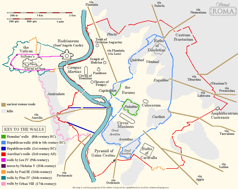
The remains of the Servian walls, also known as republican walls, dating back to the 4th century BC, are so scanty that it would not be worthwhile dedicating a real tour to their visit. Many of them appear as simple fragments, incorporated in structures built later in time, or partly hidden by the weeds, often rather small, and scattered over several districts.
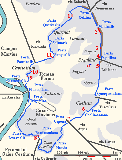 |
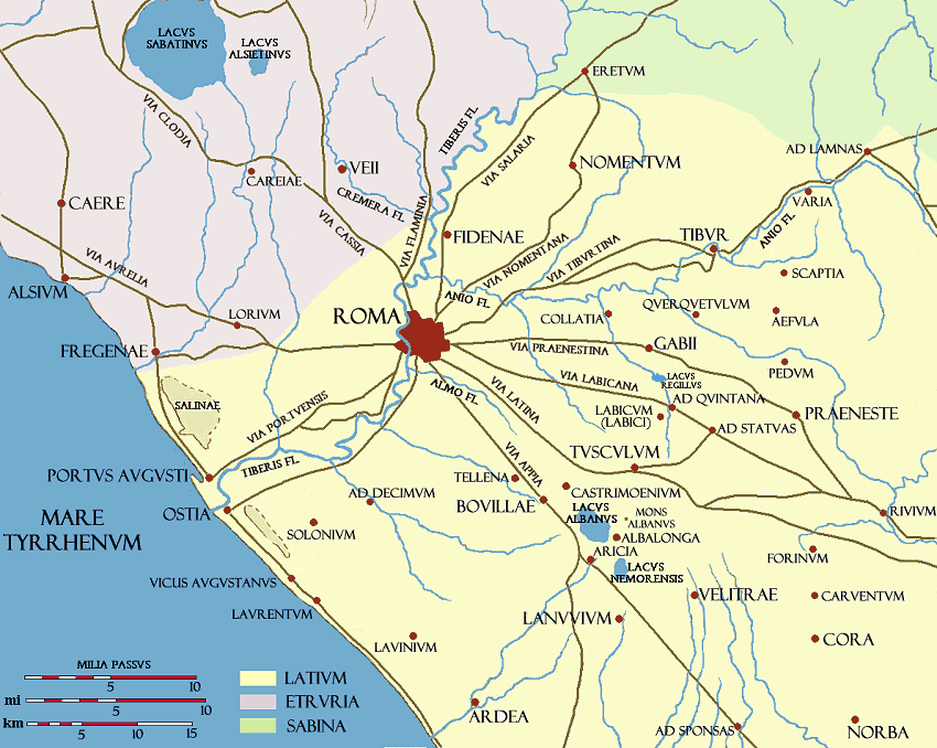
The schematic map shown on the left features the perimeter of the set of walls during the Republican Age, retrieved thanks to literary sources and archaeological excavations; the very few parts still standing are marked on the map, as well. All in all, these remains, yet modest in their scanty appearance, represent an important relic of the city's first real boundary; it is also interesting to compare the several structural differences between this wall and the one that emperor Aurelian had built no less than five hundred years later. The rest of the page describes the fragments still extant in locations accessible to the public; the progressive numbers are consistent with the ones in the map. Fragments of the wall known to exist in private buildings are not shown (with the exception of the remain mentioned at no.10). ← Servian walls during the Republican Age 
|
|---|
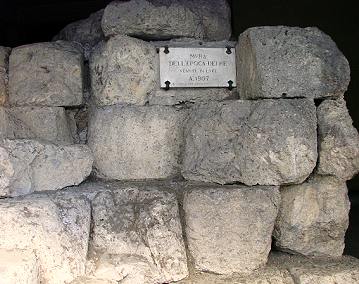
| 1. via Antonio Salandra At the end of this street, a few metres before joining via Piemonte, there is a 20-metre long surviving stretch of wall. By the end of the 19th century, the remain was enough unlucky to find itself standing on the site of a modern crossing, so had to be cut into three parts for traffic reasons. The segment on the western side of the street, closed by an iron gate, provides an excellent cross section of the structure, which enables to see how these large blocks were assembled together in a very simple way.  |
 The segment on the opposite side, now covered by a porch, is the longest of the three, while the last part, on the northern side of via Carducci, ends in the wall of a building. Just a few metres further from this spot, the brownish Aurelian's walls can be seen in the distance, closing via Piemonte at its very end. |
2. piazza dei Cinquecento
The longest surviving stretch of these walls is the one on the left side of Rome's central train station, Stazione Termini. It stands in a long garden, now protected by an iron railing. Immediately to the north stood the Porta Viminalis gate, no longer extant.
This part of the wall represented the north-eastern part of the boundary, where for almost 1 km (slightly over � mile) an agger, i.e. a mound made of earth and filling material, was piled along its inner side, to strengthen it; the filling material came from a large trench dug on the outer side, which acted as further protection.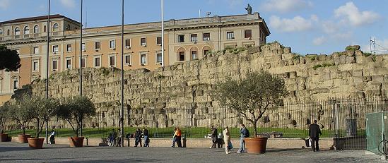 |
 |
 |
Other large fragments belonging to the same wall can be seen in the shopping alley below the station (in roman times, the original ground level was much lower than the present one); they have been identified as a part of the counterscarp that prevented the agger from sliding down. Not far from here stood the northernmost gate, Porta Collina: two important roads leading to the north-east, via Salaria and via Nomentana, started from this spot (further details about these roads can be found in the section about Aurelian's Walls, northern side, page 2 and page 3. |
|---|
| 3. piazza Manfredo Fanti In the middle of this square, in the garden in front of the Roman Aquarium (a large white building with a dome) are a few blocks belonging to the republican wall. Along its external side traces of a brick house are left, easily told by their reddish colour. When the city expanded beyond the early boundary, it became a custom to build houses with one side against the old wall, in order to make them more steady. During the late empire (4th - 5th centuries) the same happened on the outer side of Aurelian's wall (see part II page 2). |
 |
|---|
4. via di San Vito
This short and narrow road, which runs from via Merulana to via Carlo Alberto, is crossed by an arch of white travertine, named after Gallienus (emperor from AD 253 to 268), whose name, together with his wife Salonina's own, appears in the dedication above the archway:
WHOSE UNSWERVING VIRTUE IS ONLY EXCELLED BY HIS MERCY, AND TO THE VERY WHOLY SALONINA... (the last words are missing)  |
 |
|---|
| The site corresponds to the ancient Porta Esquilina, that was turned into a triumphal arch for Gallienus, likely after the gate had fell into obsolescence; the emperor ruled from AD 253 to 268, very few years before the making of the new set of walls by Aurelian (c.275). Originally, the triumphal munoment had three archways, but the two side ones, smaller in size, are no longer extant. An important road crossed the arch, via Labicana, leading toards Labici, and then further south (see map of ROME'S ANCIENT SURROUNDINGS). The monument is also popularly known as the arch of St.Vitus, after the name of the church that now flanks it. On the right side of the church, along via Carlo Alberto, another small fragment of the Servian wall is easily identifiable, where its large blocks now bulge from a building, supported by bricks. |
 |
|---|
 |
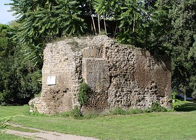
5. largo Giacomo Leopardi A scarce trace of the wall can be found by the so-called Auditorium of Maecenas, the underground remains of a nymphaeum that belonged to the villa of the famous diplomat, who lived in the 1st century BC, now protected by a brick structure that covers the site. Originally, the wall ran across this spot, but when the villa was built the defensive structure had likely already fallen into disuse. Some of its surviving blocks now bulge from one side of the nymphaeum's modern cover. |
|---|
✱ via Equizia (Servian-like wall)
A 20 meter-long stretch of wall built with tufa blocks in opus quadratum style, very similar to others described in this page but completed with bricks, can be seen not far from spots 4 and 5 in the map.
| It represents an interesting example of recycling of the useless remains of the republican wall during the imperial age. Above this structure stands the ancient church of St.Martin in Monti, founded in the 4th century and built on one of the steepest spots in Rome, the top of the Fagutal Hill (one of the three pikes of the Esquiline Hill), at the point that the making of a flat ground where to rest the building was required. The blocks it is made of undoubltly come from the Servian wall, but unlike the original opus quadratum, which followed the dry stone technique, these ones are kept together with a rough mortar, proving that they were arranged sometime later. | 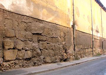 |
|---|
 The beauty and the magical atmosphere of this site remained almost unchanged through the centuries. The narrow street beyond the archway leads to the ancient church of St.Paul and St.John, whose buttresses form a picturesque series of arches. |
6. via di San Paolo della Croce On a charming spot on the top of the Coelian hill stands a small ancient archway, whose inscription bears the names of two consuls, Dolabella and Silanus (AD 10): this is the site of one of the gates of the republican walls, Porta Caelimontana. Following the expansion of Rome's urban territory, the gate lost its original purpose, and was altered by the consuls into a simple archway. When around the late 1st century AD a branch of a city aqueduct, named Arcus Caelimontani was built to provide the Coelian Hill with water (see Aqueducts, part III page 1), the tall duct crossed this spot, resting over the steady archway, where its remains are still seen today.  |
7. piazza di Porta Capena
At the southern end of the area where the Circus Maximus stood is a wide avenue, viale delle Terme di Caracalla, leading to Rome's most famous ancient Baths.
 |
At the beginning of the avenue, a stout square ruin lies in the grass on the eastern side of the road, opposite the site of the Axum obelisk: it is believed to be the remains of Porta Capena, the gate from which via Appia, also called regina viarum ("queen of the roads") originally started. In fact, the present wide avenue corresponds to the first stretch of the ancient road; via Appia, though, now maintains its old name only beyond Porta San Sebastiano (see Aurelian's Walls), that stands about 1.2 km (¾ mile) further south. Since the ruin is not made of the usual large tufus blocks, but mainly of bricks, this may have been a fragment of a house, (or another structure), built against the old wall once the latter had turned obsolete, rather than a part of the gate itself. |
|---|
8. piazzale Albania - via di Sant'Anselmo
Piazzale Albania is a long square that lies in the valley between the Great Aventine and the Small Aventine, from where via di Sant'Anselmo climbs towards the top of the major hill.
 |
 |
A relatively long stretch of Servian wall, protected by a tall iron railing, stands on the spot where the aforesaid street meets the square, while a similar part of the wall is still standing on one side of the same street, only a few metres further uphill. |
|---|
| 9. Capitolium Hill A small fragment of wall, halfway between the no longer extant Carmentalis and Fontinalis Gates, lies along the side of via del Teatro Marcello that follows the northern side of the Capitolium Hill; the tufa blocks are partly hidden by the thick vegetation. |
 |
|---|
 |
10. Capitoline Museums A small part of the wall is visible inside the Capitoline Museums, in the underground passage that connects Palazzo dei Conservatori to Palazzo Nuovo. It is inserted below the ceiling, by the base of the flight of steps that leads to Palazzo Nuovo, and it shows that the height of the original ground level was much lower than the present one. |
|---|
| 10. largo Magnanapoli At the end of the valley between the Quirinal hill and the Viminal hill (corresponding to the present via Nazionale), just opposite to Trajan's Markets, in the middle of a traffic roundabout decorated with exotic trees is a small fragment of the wall, labelled as "remains of walls from the Age of Kings" (i.e. the Servian wall) discovered in 1875", during the works for the refurbishment of the aforesaid street.  |
 One of the most interesting features is housed in the hall of the historical building facing the roundabout, Palazzo Antonelli, at no.157, now a branch office of the Bank of Italy. Ask the porter to let you see "the roman arch": he will show you the way to a semicircular archway that has been encased in the building's structure, probably on the same spot where it originally stood, a very unusual architectural combination. It was believed to be the Porta Sanqualis, but in recent years this interpretation has been rejected, on the grounds that the base of the Servian wall was at a much lower level. So this is very likely one of the windows through which ballistae (weapons similar to catapults) could launch stones and other large projectiles. |
Other small ancient Roman fragments are on display in the same hall, and in the adjacent courtyard.
 |
|