 |
 ~ D.I.Y. Rome ~ an online guide, with maps and suggested routes |
 |
|---|
 |
|---|
INTRODUCTION
Rome is the city in the world with the longest set of ancient walls still partly standing. This unique relic of Roman history, though, is somewhat neglected by the thousands of tourist who visit the city every day: very few of them pay attention to these massive structures, as their interest is mainly caught by famous buildings and sites such as the Roman Forum, the Pantheon, or the Colosseum.
Certainly less beautiful than these gems, the walls proved more useful to the city than any other well-known monument or building. And still today they stand as an important memory of the city's ancient boundaries.
| The several restoration works carried out through the ages, in order to keep them strong and steady, give reason for the good state of preservation of the set of walls built in the 3rd century AD: unlike other ancient buildings, they mantained their original function until the end of the 1800s. Many of the original gates are still in place, as well, and some of them have witnessed important historical facts. Besides their importance during wartime, the city walls enabled the local authorities to keep under control the many people who every day entered or left Rome, as the only way in or out was through the gates: the doors were usually kept under sentry during daylight, and closed after dusk. And since a tax was usually imposed on people and on goods entering the city, the gates yielded also a considerable income for the municipality. |
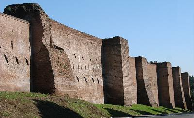
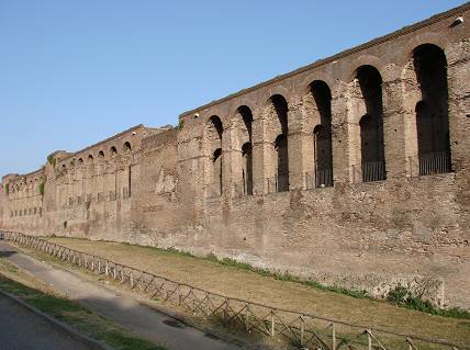 stretch of Aurelian's Wall by St.John's Gate |
|---|
Much more than weapons, the worst enemies of Rome's ancient walls are invisible: water infiltration, weed roots, and in modern times air pollution too, represent a constant menace that seriously jeopardizes the steadiness of these massive giants, causing them to crumble. The collapse of a whole stretch of Aurelian's wall on the southern side (now fully restored), occurred only a few years ago, acted as a serious alert.
The city's authorities are presently keeping under control the structural stability of a sample stretch of wall, with the aid of teams of experts, in order to tune up new diagnostic techniques which in the future should allow a permanent monitoring of the whole set of walls.
Regretfully, Rome's walls are not walkable, like the medieval ones found in many other European cities, except along a very short stretch on the southern side. This is partly due to the structure of the same walls, and especially to security reasons. Nevertheless, it is possible to follow the main set of walls all round its original perimeter: this long, interesting and rather unusual tour of the city takes the visitor through many districts, some of which away from the commonly visited areas. A few remains, located not far from the walls and gates, can also be reached by making short diversions from the main route; for those who do not fear adding a little extra effort to the already long walk, these sites can represent an interesting addition to the main tour.
The main aim of the following pages is an invitation to visit these walls, either virtually or actually.
I have tried to keep in mind both the many visitors who will take the more comfortable tour, sitting in front of their PC monitors, but also those who are planning to visit Rome (or will hopefully do so, after browsing these pages). The guide has plenty of pictures, a full description of what can be seen and detailed maps with a suggested route: those who would like to take the tour of the wall, either on foot or by bike, can print the pages and use them as a reference.
To access the different parts of this section scroll down the page up to the historical notes about the relevant set of walls, or follow these direct links:
|
|
|
|---|
In the parts dealing with Aurelian's walls and the walls of the popes, the header of each page carries the following options:
|
 |
 |
|
|||||
|---|---|---|---|---|---|---|---|---|

| 
|
|
HISTORICAL NOTES |
|---|
| Since the earliest stages of its foundation, Rome has always adopted defensive means to prevent hostile people from invading the city. They are not one single structure, but separate sets of walls that date back to various historical periods, built with different techniques, according to the weapons that were in use in those days, from stones hurled by the earliest enemies, catapults, bows and crossbows, up to more powerful cannons and guns. Each of them is dealt with individually. They are all conventionally named after the ruler (king, emperor or pope) who had them built. A map of their winding directions and of the ancient roads that ran through the gates, click on the image above. |
click on the picture for an enlargement
|
|---|
|
THE WALLS OF ROMULUS
(THE SQUARE ROME) |
|---|
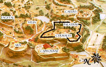
| Little is known about the very first defensive structures that eclosed Rome's earliest nucleus, over 2700 years ago.
According to several historical sources (Plutarch, Tacitus, Appianus) a four-sided set of walls, the so-called square Rome, may have stood all around the Palatine, the hill where by tradition Romulus marked with a plough the first boundary of the city, including its two peaks (Cermalus and Palatium), whose direction basically followed that of the aforesaid furrow (on this topic see also further, the Pomerium).
hypothetical reconstruction of → the square Rome on the Palatine Hill |
 |
|---|
") |
However, other hypotheses mention the existence of a defensive wall only along the most unprotected parts of the hill. So far, very few traces of such structure have been found. Therefore, these walls are not dealt with by the following pages. ← a model of the walls of Romulus (Museum of Roman Civilization) |
|---|
|
THE SERVIAN WALLS
(REPUBLICAN WALLS) |
|---|
| They are named after Rome's sixth king Servius Tullius: by tradition, he was the first ruler to order the construction of an early defensive structure around the city. Also in this case it is impossible to state a precise date. According to reliable sources, by the 6th century BC Rome's boundary could indeed rely on some kind of protection; nevertheless, there is enough evidence that a real wall was not built until the late 4th century BC, during the republican age, whence their alternative name. In particular, Livy (i.e. Titus Livius) mentions that shortly after Rome's devastation by the Gauls, in 390 BC, new taxes were levied for the making of a wall of stone blocks (Ab Urbe Condita, book VI). A further extension that stretched beyond the left bank of the river Tiber up to the top of the Janiculum Hill, was then built two centuries later. Therefore, this set of walls developed in a rather complicated way. |
 |
However, in the archaic age other cities in Rome's surroundings were protected by walls, and some claim that Rome too might have had them.
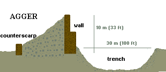 |
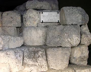
After the sack of Rome by the Gauls led by Brennus (390 BC), a set of walls took the place of the earlier and weaker boundary. Along the north-eastern part of its course, a deep trench could still be found outside the wall, as a part of a structure called agger (from the Latin ad gerere, "to bring, move towards"): the earth and stones dug from the trench were piled on the inner side of the boundary, between the wall itself and a counterscarp (i.e. a lower wall that prevented its downslide). |
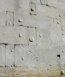
| Either belonging to the agger or standing alone, the wall was built according to the dry stone technique, i.e. large square blocks (opus quadratum) were piled one on top of the other, in multiple rows, without using any mortar to keep them together. The blocks are made of tufa, a porous rock consisting of consolidated volcanic ashes, commonly used as building material since ancient times (in Rome tufa was used for the making of buildings up to the early 1930s!), of different qualities according to the stretch of wall. Unfortunately, no more than a few fragments of these walls are now left standing, scattered in various parts of the city, sometimes in strange places where it would be difficult even to figure that once by that spot ran a defensive wall. The full perimeter of the Servian Walls could be defined, more or less precisely, thanks to data based on historical sources and archaeological excavations; it measured almost 11 km (6.5 miles). |
 fragment of frieze from the Basilica Aemilia (179 BC) that features two workmen building the wall |
|---|
 detail of the variety of tufa known as cappellaccio; its several whitish inclusions are of volcanic origin |
By the end of the 4th century BC the city boundaries enclosed the famous seven hills, or Septimontium, over which the city was originally built: the Capitolium and the Palatine (i.e. the early nucleus), the Aventine, the Esquiline, the Quirinal, the Viminal and the Coelian. Very soon, though, the city began to expand rapidly, especially from the late 1st century BC, during the imperial age. THE SERVIAN WALLS 
|
|---|
|
AURELIAN'S WALLS |
|---|
| By the 3rd century AD Rome had expanded so much beyond its old boundaries that the Servian walls had become useless.
Therefore emperor Aurelian, who had reunited the crumbling empire and quelled internal
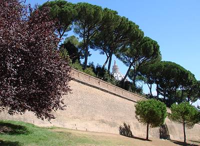
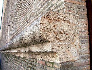
revolts, decided that time had come to build a further set of walls, and to do so as soon as possible: in only five years (from 271 to 275) Rome's new boundaries enclosed a much wider area, especially on the western side of the city. Nevertheless, Aurelian did not live long enough to see the work finished, as he died a few months before it was completed. The new defensive system was built with bricks. Unlike the previous set of walls, these ones had square towers at regular distances, and a walkable passage on the inner side that the soldiers used for moving along its length, remaining fully protected (see the opening picture and the one below). |
 |
|---|
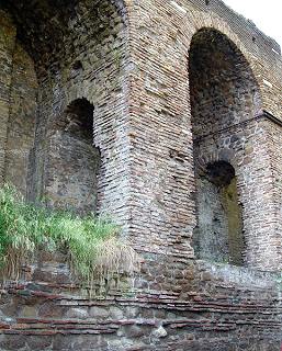 detail of the walkable passage on the inner side |
These are the walls still standing for most of their length, with the only exception of the western stretch built over the Janiculum Hill, replaced by the popes' walls during the first alf of the 1600s. During the centuries, restoration works were carried out many times, what can be told by the different brick and stone textures, by some inscribed plaques and by several different coats of arms of the popes who had the works carried out. Also most of the gates, albeit standing on their original sites, have gone through changes; some of them has been walled up, some others have been refurbished according to new functional needs. But they all maintain their fascinating allure. The works for the making of Aurelian's wall carried on so hastily that when their scheduled direction ran across large buildings or monuments steady enough, no change was made to the project, nor anything was taken down, but the structure was either incorporated and became itself a part of of the set of walls, ot it was simply run across. |
|---|
| Despite their hasty making, these walls proved far more steady than any ancient architect would have ever imagined: after seventeen troubled centuries, catapults, battering rams, cannons, bombs and even earthquakes were not strong enough to make them crumble. Nevertheless, from time to time the wall was subject to damages caused by enemies, or simply due to ageing: on such occasions restoration works were required. In ancient Roman times, both the walls and the gates were built according to criteria essentially inspired by practical purposes: defensive systems showed no trace of decorations nor embellishments. The gates were simple archways, not very tall, while the walls, which lacked a crenellation, were marked by towers with a square section, set at regular distances. |
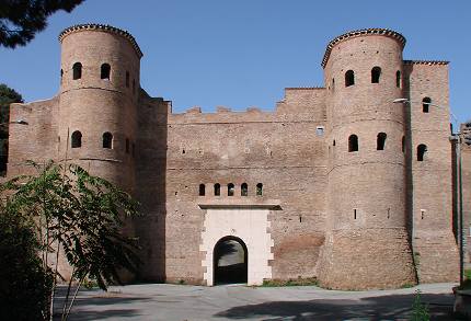 Porta Asinaria features the typical alterations by Honorius |
|---|
By the turn of the 5th century, the young emperor Honorius, fearing an impending attack by the barbarian populations, had the extant gates altered by facing them, either partly or in full, with a thick white stone layer that covered the brick texture, making it more resistant to enemy assaults.
|
 detail of the stone layer: note the portcullis rail and the small Latin cross on the keystone of the arch |
|---|
But such measures were not enough to prevent Rome's fall to Alaric I, king of the Visigoths, only about a decade later, in 410.
Also in 537-538 the walls witnessed another siege of the city, which in the meantime had been taken by the Bizantynes, this time by the Ostrogoths led by general Vitiges; this gave historian Procopius of Caesarea the opportunity of leaving a detailed description of the clash, which also contains some interesting information concerning the wall's structure in those days; a few excerpts are quoted in the following pages that deal with the relevant stretch of wall.
During the Middle Ages, the walls and the gates remained the original ones, except for a few rough restoration and reinforcement works.
No sooner than during the second half of the 1500 two new gates were built (namely, Porta Pia and Porta San Giovanni), designed in a Renaissance fashion, while a third one of similar shape (Porta del Popolo) replaced the original Roman one. And about fifty years later also Porta Portuensis and Porta San Pancrazio were replaced with new gates during the making of the walls sponsored by pope Urban VIII.
Interestingly, Aurelian's walls kept acting as a boundary of the urban area, besides being also its main means of defense, up to 1870, when Rome was set under siege for the last time by the Italian army of king Victor Emmanuel II, who got the better of the Papal State.
After the turn of the 1900s, when the city began to stretch well beyond the ancient walls, several modern archways were opened, in order to let the growing traffic cross smoothly the old city boundary.
AURELIAN'S WALLS

|
THE POMERIUM
|
|---|
| As far as now, the actual walls have been described, i.e. the ones made of tufa blocks or bricks, that physically kept the enemies away from the city. Besides this material boundary, Rome also had a formal boundary, called pomerium (a contraction of post = "beyond" and moerium = archaic term for "wall"). It marked an inner territory, which was considered sacred: this caused some important religious and legal implications (see further). Its perimeter was marked by marble cippi such as the one in the pictures, set at a regular distance. Only eight of the original cippi have been retrieved so far, whence today's difficulty in tracing such boundary. Furthermore, the pomerium was not perfectly parallel to the walls, so that the strip of land between the latter and the sacred boundary had an irregular extension. This was partly due to the fact that when new walls were built, the pomerium was left as it was, only to be enlarged on different occasions. As a matter of fact, the pomerium was considered the true boundary of the city: whatever fell within its line was the actual Rome, whereas the land between the cippi and the walls was simply 'Rome's property'. |
 |
|---|
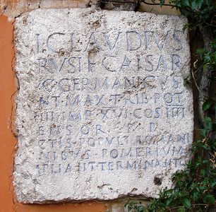 |
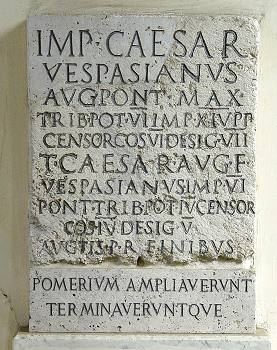
The Romans inherited the use of a religious boundary from the Etruscans, so very likely a pomerium existed since the very foundation of the city: this was the mythical line traced by Romulus, the first king and founder of Rome. The furrow left by his plough symbolized a moat. Servius Tullius, the sixth king, lengthened its course, likely by the time when a first defensive structure was built around the city. Instead it was not modified when an actual set of walls was built (4th century BC). Under the dictatorship of Sulla (82-80 BC) the pomerium was lengthened again, and then other times during the imperial period, by a number of emperors, among which Octavianus Augustus, Claudius (right), Vespasian (above), Trajan, Aurelian. The most important spots, such as the temple of Jupiter, the Fora, the Curia where the senators met, and others were inside the boundary; the Campus Martius, where the soldiers trained, the temple of Isis, the Theatre of Marcellus, and other and was outside. Also the whole Aventine Hill was left outside the original pomerium, and so did a part of the Esquiline Hill. |
|---|
|
THE WALLS OF THE POPES |
|---|
Defensive structures began to rise around the Vatican no sooner than in the 6th century. Until then, this area was rather vulnerable, as it was not surrounded by walls, nor the hight of the Vatican Hill could represent a real natural boundary against invaders.
Following the edict of Milan (AD 313) by means of which emperor Costantine I let the Christians free to follow their religion, pilgrims from many lands started to come to Rome and visit St.Peter's tomb; especially during the Middle Ages their number grew into a real multitude. The basilica, its ornaments, its treasury, gradually became a more sensible target during enemy raids.
 |
The first defensive structure that ever stood in this part of town dates back to the time when Rome fell to the Ostrogoth king Totila (546-550). He had a wall built from nearby St.Peter's basilica to the Hadrianaeum, i.e. emperor Hadrian's tomb by the river bank, which in those years was being turned into a fortress. In the 9th century Totila's wall had already collapsed several times. Saracen pirates started raiding the Roman countryside, and in 846 they reached the city walls, plundering the rich treasuries of the basilicas of St.Peter and St.Paul (both of which stood outside the city); in order to prevent further attacks, a few years later pope Leo IV had a full set of walls built around Peter's shrine, which protected the whole area where the holy building stood. The importance of this wall was that it turned the suburban district into a citadel, known as Leo's City, though not considered officially a part of Rome, until it was annexed to the urban territory as one of its districts by pope Sixtus V, in 1586. |
|---|
A few years after the savage sack of Rome by the German mercenaries sent by emperor Charles V (1527), pope Paul III (1534-49) strengthened the citadel's defense by having big bastions strategically built at the northernmost and southernmost corners of Leo's City, which by that time had already expanded beyond its old boundaries.
These bastions, though, were not yet connected by a wall. This happened only a few years later, when pope Pius IV (1559-65) decided to mark the citadel's new boundary with a further wall, which ran from Sant'Angelo Castle (former Hadrian's tomb) all the way round the Vatican, just outside the ancient wall built by Leo IV, to the bank of the Tiber.
| Also this new set of walls was made of bricks but, unlike the previous one, its outer side was shaped as a steep slope, with a white kerbstone or rim made of travertine (picture on the right) that follows the whole length of the perimeter. Arrow-shaped bastions, in place of old towers and embattlements, housed placements from which modern weapons such as cannons could be used. Curiously, today what is left of this wall still maintains its original purpose, as it marks the official boundary between the Vatican State and the Italian Republic. A further extension was then built about half a century later by Urban VIII (1623-44), along the top of the Janiculum Hill. Since the old wall by Aurelian was no longer in good condition, the pope decided to enclose the upper part of the hill within Rome's territory, thus expanding the city towards the west, yet slightly shortening the ancient Roman boundary at the southernmost end of this stretch of wall. |
 |
|---|
 |
Thanks to this last addition, as of the 17h century the city was surrounded once again by a full set of walls, from Porta Flaminia (now Porta del Popolo) to Sant'Angelo Castle; between these two ends a small area remained unprotected, but still within the fire range of the castle's artillery. Clicking on the button on the left brings out a map that shows the extension of the ancient walls compared to the modern city. |
|---|
THE WALLS OF THE POPES
