 |
 ~ Roman Monographs ~ Aqueducts · part I · |
|
|---|
ROME'S MANY 'WATERS'
 the famous view of the Aqua Claudia, in the Aqueducts Park, between via Appia Nuova and via Tuscolana |
|---|
Water has always been one of the most important resources for a city, and ancient Rome was famous for its great wealth of public fountains, baths, artificial pools and reservoirs, naval arenas (naumachiae), irrigation channels, and other similar facilities. During a time length of over 500 years, eleven main aqueducts, plus a considerable number of branches, were built for Rome's urban needs. It has been assessed that, all together, the total output of these aqueducts was considerably more than the daily amount of water the modern city can rely upon today.
| This plenty, which no other place in the world ever had, was worth Rome the name
of regina aquarum, i.e. "queen of the waters". Interestingly, the Romans did not give a name to the aqueducts themselves, but to the water they carried, so that most of them were referred to as aqua (Aqua Appia, Aqua Marcia, Aqua Iulia, etc.), often named after the ruler or government officer who sponsored or presided over their making. Since the time Rome was founded, the inhabitants could rely on the water of the Tiber, which ran along the western urban boundary (today it cuts the modern city into two halves), and on its main tributary, the Aniene, which meets the larger river about 4 km (2 ½ mi.) north of the earliest city walls, on a spot now surrounded by modern districts. |
 the course of the Tiber and of the Aniene (blue lines), compared to Rome's extension in different ages: 4th century BC (cyan line), 3rd century AD (red line), 20th century |
|---|
During the age of kings, and for some time of the republican age, the population satisfied its needs by drawing water directly from these rivers, from minor channels, and from a number of smaller sources such as wells and cisterns for rain water.
In the 4th century BC the size of the city and the growth of the population, including the many immigrants, the foreign merchants and the slaves, required a larger supply.
 |
In fact, in 312 BC censor Appius Claudius had the first aqueduct built; it drew
water from a spring located between 7 and 8 miles east of the city, although the total length of its course measured no less than 11 miles (the reasons of such crooked direction will be explained in part II). The making of the following aqueducts came at an average rate of one every 60 years or so, but in AD 52 two of them were built almost at the same time. |
|---|
| The last one, built in AD 226, was the Aqua Alexandrina, named after emperor Alexander Severus. Also this one drew water from springs located not far from the via Praenestina, east of Rome, and also this one, as it approached the city, ran through an undeground tunnel; but so far, the latter part has never been identified. | 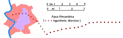 |
|---|
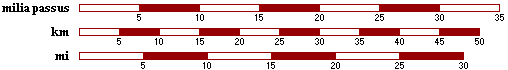
The length of the aqueducts was expressed in passus ("steps"), a measure corresponding to 1.482 m or 4 ft 10¼ in). More approximately, they were measured in milia passus, i.e. Roman miles, actually meaning "thousands of steps", equals to 1.482 Km, or 0.92 miles.
In ancient Rome the aqueducts were managed by a curator aquae ("water curator"), i.e. a high officer in charge for anything concerning the city's water resources. In particular, by the end of the 1st century AD, one of these officers, named Sextus Iulius Frontinus, wrote a very detailed essay entitled De aquae ductu urbis Romae ("about the acqueducts of the city of Rome"), which represents the main source of information about the local waterworks in ancient Rome.
The following is a list of the ancient aqueducts, according to a chronological ordering; it also shows which parts of the city they served. The location of their springs refers to the distance and position from the city center (i.e. the Capitolium Hill), expressed in Roman miles.
| AQUEDUCT |
NAME REFERENCE |
YEAR OF CONSTRUCTION |
LOCATION OF THE SPRINGS |
LENGTH OF THE DUCT |
LOCATION OF THE MAIN OUTLET |
|---|---|---|---|---|---|
| AQUA APPIA | censor Appius Claudius Caecus | 312 BC | 7-8 miles east | 11.2 miles | Circus Maximus (south west) branches for most districts |
| ANIO VETUS [1] | "old Aniene" | 269 BC | 29 miles east | 43 miles | Porta Esquilina (south-east) |
| AQUA MARCIA | praetor Quintus Marcius Rex | 144 BC | 36 miles east | 61.7 miles | Quirinal Hill (north-east) |
| AQUA TEPULA | "warm water", due to its temperature | 125 BC | 10 miles south-east | 12 miles | Porta Collina (north-east) |
| AQUA IULIA | emperor Octavianus' family name | 33 BC | 12 miles south-east | 15.4 miles | Porta Viminalis (north-east) branches for many districts |
| AQUA VIRGO | "maiden water", from a legend | 19 BC | 8 miles east | 14.1 miles | Campus Martius (north-west) |
| AQUA ALSIETINA | Alsietinus Lake (now Martignano Lake) |
2 BC | 14 miles north-west | 22.2 miles | Trans Tiberim (west) |
| AQUA CLAUDIA | emperor Claudius | AD 52 | 38 miles east | 46.4 miles | Porta Praenestina (south-east) branches for most districts |
| ANIO NOVUS | "new Aniene" | AD 52 | 38 miles east | 58.7 miles | it shared the same outlet of the Aqua Claudia |
| AQUA TRAIANA | emperor Trajan | AD 109 | 13 miles north-west | 38 miles [2] | Janiculum Hill (west) |
| AQUA ALEXANDRINA | emperor Alexander Severus | AD 226 | 14 miles east | 15 miles [2,3] | Pantheon, Campus Martius (north-west) |
[1] - The original name was Anio; the adjective Vetus ("old") was added over 200 years later, when the Anio Novus was built.
[2] - The length is approximate, as the aqueduct was built after the death of Sextus Iulius Frontinus and [3] part of its course is still unknown.
The rate of flow of each aqueduct was expressed in quinariae. It has been calculated that 1 quinaria was equals to 0.48 litres/second. The most powerful of the eleven aqueducts, the Anio Novus, drew 4,738 quinariae, which meant a supply of almost 200 million litres per day!
The earliest graphic record of the aqueducts appears in the Forma Urbis Romae, an ancient and very detailed city plan dating to the early 3rd century AD, carved in stone in scale 1:240, some fragments of which still exist. One of them in particular features an outlet at the end of a duct, with the word AQVEDVCTIVM.

 (above ↑) a 1590 map, showing a no longer existing part of the Aqua Virgo (highlighted in yellow), on the the Pincio hill; (right →) a map dated 1472 features an aqueducy branch called Arcus Caelemontani (see part III), located behind the Colosseum |
Several maps of Rome from the Renaissance and Baroque ages, instead, show three-dimensional aerial views of the many parts of the aqueducts still standing by the 15th-17th centuries. Thanks to these sources and to archaeological excavations, it has been possible to trace the course of most ancient Roman aqueducts, although due the city's development in time very little of these majestic structures has survived.  |
|---|
|
 part II |
 part III |
 part IV |
 |
|---|