 |
 ~ Roman Monographs ~ Aqueducts À part III À PAGE 1 |
|
|---|
WHAT CAN BE SEEN TODAY
| For centuries the remains of the ancient aqueducts have been one of the favourite subjects of painters and engravers, although the best preserved parts obviously stand far away from the city's central districts. The purpose of part III is to point out the remains of Roman aqueducts, mainly located in the suburbs. These districts today are inhabited, rather densely too. But up to the first half of the 1900s they were countryside, where the tall aqueducts did not cause any hindrance to vehicles, nor occupied any precious building land. Therefore, the farther one moves from the 'official Rome' that most turists visit, the more the standing remains are well preseved, and some stretches still boast their original might, as these pictures clearly show. |
 well-preserved series of arches of the Aqua Claudia |
|---|
 series of arches of the Aqua Alexandrina |
After having been damaged during a siege in the early 6th century (a historical account can be read in part IV), the aqueducts simply turned into useless and bulky structures, which mainly acted as a source of spare building material, such as bricks and stones. Also earthquakes and further wars took part in damaging what was left; this gives reason for the very few traces now left within the ancient urban boundaries, i.e. today's central Rome. Some interesting parts are still standing in the southern and eastern outskirts of the city. For practical purposes, what can be seen is grouped and described in three pages, according to the location of the remains. |
|---|
By running the mouse cursor over the pictures in this page, the specific location of the relevant subjects is shown.
| page 1 (this one) AQUEDUCTS BY THE CITY GATES |
page 2 AQUA CLAUDIA AQUA MARCIA ACQUA FELICE |
page 3 AQUA VIRGO AQUA TRAIANA AQUA ALEXANDRINA |
|---|
Before becoming the main south-eastern city gate of Aurelian's wall (c.AD 275), Porta Praenestina, now called Porta Maggiore, was a double arch of the local aqueduct.
| The same can be said of the next eastern gate, Porta Tiburtina (see also Aurelian's Walls, part II, page 1 and page 2 for details and further pictures). In fact, on the spot where aqueducts crossed important roads, such as the aforesaid ones did by via Praenestina and via Tiburtina, respectively, arches featuring special decorations were often built, to celebrate the emperor who had sponsored the making of the aqueduct (more often, an emperor). When the set of walls by emperor Aurelian was drawn, these two arches were incorporated within the new defensive structure. But despite being turned into gates, they continued acting as ducts, carrying water in the upper part: the Aqua Marcia, Aqua Tepula and Aqua Iulia ran above Porta Tiburtina, while the Aqua Claudia and Anio Novus ran above Porta Praenestina. |
 Porta Praenestina (now Porta Maggiore): two ducts ran above its arches |
|---|
The area just before Porta Praenestina was called ad Spem Veterem (see part II); here five different 'waters' converged (actually six, including the underground course of the Aqua Alexandrina, although its duct has never been found). They conveyed over 70% of Rome's total water supply: the following diagram shows the direction of these aqueducts according to archaeologist Rodolfo Lanciani (late 19th century), although the graphic 3-dimensional elements have been taken and adapted from Étienne Du Perac's map of ancient Rome (1576).
It also features the parts that Sixtus V recycled for his Acqua Felice. What is still standing is coloured in tan, and what has gone lost is in light grey.
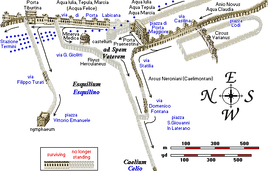 the net of aqueducts in south-eastern corner of Rome: the ancient place names are shown in black, the modern ones are in blue, and the dots indicate the present railway line |
The Aqua Marcia, Tepula and Iulia followed Aurelian's wall, pointing towards Porta Tiburtina. Before reaching the gate, the Aqua Marcia gave off an important branch called the Rivus Herculaneus, which might have likely served the nearby nymphaeum of the Licinii family, more commonly known as Temple of Minerva Medica (see Aurelian's Walls, part 2 page 3). The Rivus Herculaneus carried water to the Coelian Hill, in the southern half of republican Rome, and then ran underground, parallel to the earlier Aqua Appia, reaching the Aventine Hill (south-west). Nothing of this branch has survived, except stretches of the underground duct. |
|---|
Only vintage photographs (19th century) feature on the Aventine Hill a few surviving arches belonging to a branch of the Rivus Herculaneus that provided water to the Suran Baths, a facility that once stood between the present Rose Garden and the church of St. Prisca, and was named after Lucius Licinius Sura, a general and friend to emperor Trajan.
By Porta Tiburtina the triple aqueduct diverged from Aurelian's wall, pointing straight towards the Quirinal Hill, i.e. northbound. Here the Aqua Marcia gave off another major branch, built by the end of the 3rd century, called Aqua Iovia, which carried water to the enormous complex of the Baths of Diocletian.
In 1587 this part of the Aqua Marcia was turned into the newborn Acqua Felice aqueduct. In the late 1800s, though, due to the making of the nearby Termini Station, every part of the viaduct from Porta Tiburtina towards the city was taken down. Only its first 100 metres/yards approximately were left standing; they end with an arch celebrating Sixtus V, which runs straight away at right angles into the railway station's wall, in piazzale Sisto V, as described further in this page.
Instead the Aqua Claudia and the even richer Anio Novus shared the same main outlet, located very close to Porta Praenestina, although the last remains of their castellum disappeared in the late 1800s.
 |
 |
|---|
ARCUS NERONIANI, OR ARCUS CAELIMONTANI
| Before reaching its main outlet, also the Aqua Claudia gave off a large branch that emperor Nero had originally built for his Golden House, whence its old name Arcus Neroniani, "arches of the Neros" (Nero was a family name of the gens Claudia). When the Golden House was dismantled, the branch was altered to reach the Coelian and Aventine hills, and renamed Arcus Caelimontani, i.e. "arches of the Caelimontium", ancient Rome's second district, which included the Coelium and its minor reliefs (see also The 22 Rioni). This caused the aforesaid Rivus Herculaneus to become obsolete. |
 |
|---|
 |
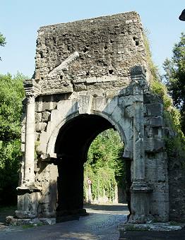
A further extension of this branch that reached the Palatine hill, in the centre of imperial Rome, was built by emperor Domitian by the late 1st century. The first part of the Arcus Caelimontani can be followed more or less up to the Lateran grounds, while only few fragments of the further part are left along the Coelian Hill, especially by the church of Santo Stefano Rotondo. Just past the church, a few tall arches of the aqueduct touch the site where once stood Porta Caelimontana, one of the gates belonging to the set of Servian Walls (4th century BC). In AD 10 two consuls, Dolabella and Silanus, mentioned by an inscription above the passage, refurbished it into its present shape. The arch was renamed after them.  (↑) detail of the names of Dolabella and Silanus from the inscription over the archway; (← left) the complex including the arch and the remains of the aqueduct |
|---|
Curiously, inside one of the aqueduct's pillars are two rooms, in which St.John de Matha (1160-1213), founder of the Order of the Trinitaries, or New Crusaders, dwelt for two years.
 |
 |
|---|
of Rome of the 17th century by Giovanni Maggi, where they are still today (right)
| The last few fragments of the Arcus Caelimontani can be seen some 200 metres or yards further west, integrated by a modern brick texture, as they cross the valley formed by the Coelian and Palatine Hills (now corresponding
to via di San Gregorio, that runs downhill from the Colosseum towards the southern end of the Circus Maximus). Beyond this spot, the aqueduct reached its final destination: the complex of imperial buildings on the Palatine.
the last stretch of the Arcus Caelimontani reaches the Palatine Hill →
Since in ancient Rome this was a rather busy district, secondary branches of the Arcus Caelimontani very likely carried water to the fountains of the Circus Maximus, to the establishments that stood along the banks of the Tiber (very close to the opposite end of the circus), and so on. |
 |
|---|
What today can be seen of this branch is partly the result of a restoration and consolidation carried out under emperors Septimius Severus and Caracalla (early years of the 3rd century).
The short stretch of aqueduct that now crosses via Turati belonged to another minor branch; its direction points towards the nearby remains of a huge fountain.
 the aqueduct in via Turati |
 the remains called Marius' Trophies |
|---|
It is traditionally believed to be a branch of the Aqua Iulia; but due to the height of its specus, some suggest that it might have been connected either to the Aqua Claudia or to the Anio Novus.
 |
The aforesaid remains now stand in the gardens of piazza Vittorio Emanuele. The fountain they once belonged to has been identified as the nymphaeum built by emperor Alexander Severus, whose popular name is Marius' Trophies, after two groups that once decorated its sides, featuring weapons, shields and armour, taken from barbaric tribes as trophies of war. More details can be found in the Fountains monograph. | ") the nymphaeum in an etching by Étienne Du Perac (mid 16th century): the Trophies were still standing below the no longer extant side arches; (← left) presently they decorate the top of the Capitolium's staircase |
|---|
In the 1500s the 'trophies' were still in place; Renaissance illustrations, the earliest available since the classic age, feature them standing on the monument, already turned into a ruin (above right); by the end of the century they were moved to the Capitolium Hill (see I Rioni section, and Capitolium Square for details).
Just off Porta Tiburtina, the direction of the aqueduct with three water tunnels (i.e. Aqua Marcia, Tepula and Iulia) made a westward bend, diverging from the straight line followed by the city wall; actually, to say that the wall diverged from the aqueducts would be more correct, as the latter were built earlier in time. From this spot the three aqueducts ran towards their water castles, located somewhere in the northern part of Rome; one of them probably stood by the Baths of Diocletian. What we see today, though, is the aqueduct built in 1587 under pope Sixtus V, who took advantage of the ancient roman structures, still partly standing, and literally recycled them for the making of his project, the Acqua Felice, whose main outlet, or 'display' fountain, known as the Fountain of Moses, was built about 350-400 metres or yards north of this spot (see part III page 2 and Fountains part III page 6 for further details).
| But by the time the Termini railway station was built, around 1870, also the Acqua Felice aqueduct had meanwhile turned into a bulky relic. Therefore, since it ran across the site of the newborn station, it was taken down for most of its length. From the spot where the Acqua Felice (built out of the ancient Aqua Marcia) branches off the set of city walls, only a few metres of the aqueduct were left standing, as the picture shows. Fortunately, the surviving stretch includes the 'special' double-sided arch that Sixtus V had built on the spot where the Acqua Felice crossed via Tiburtina, the main road that approached Rome from the east. |
 the archway of Sixtus V, adjoining the station (left) |
|---|
The Arch of Sixtus V is similar in shape to another one called Porta Furba (described in page 2): also this one features in its top part two large inscriptions that read:
 the archway's inscription on the northern side |
BUILT AT HIS EXPENSES THE DUCT OF THE ACQUA FELICE BY UNDERGROUND FLOW FOR 13 MILES, BY ARCHWAY VIADUCT FOR 7 and on the other side: SIXTUS V POPE PAVED AT HIS EXPENSES THE LONG AND BROAD ROADS ON BOTH SIDES (of the arch) LEADING TO ST.MARY THE MAJOR AND TO ST.MARY OF THE ANGELS FOR THE PEOPLE'S BENEFIT AND DEVOTION |
and the small pears that decorate the side archways |
|---|


Interestingly, the boundary of the vast estate that belonged to the pope's family, Villa Peretti-Montalto, ran very close to this spot: in building the aqueduct and in paving the roads, Sixtus V had obviously kept in mind not only the people, as the inscription reads, but in first place his very own benefit.
On the main archway's keystone hangs a lion's head, from the pope's coat of arms; on its sides are the other heraldic devices of Sixtus V: the eight-pointed star (on the side of the gate facing the north, see picture above) and the three hills (on the opposite side). The two smaller archways, instead, are decorated with a bunch of pears, referring to the pope's family name (Peretti, literally "small pears"), which is though not a device belonging to his coat of arms. This is the reason for the other name which this structure is also known with: 'Pears Arch'.
Nothing is left of the fountain that once stood nearby, a welcome for thirsty travellers who entered Rome coming from the east.
 the Arch of Drusus (↑), the fragments in piazza Galeria (→) and the few arches by the Baths of Caracalla (↓) |
Immediately at the back of Porta San Sebastiano, Rome's southernmost gate (originally called Porta Appia, as it was crossed by the Appian Way), stand the remains of what is commonly referred to as the Arch of Drusus, after tribune Marcus Livius Drusus (late 2nd century BC). This fragment once belonged to the Aqua Antoniniana, a branch of the Aqua Marcia built by emperor Caracalla around AD 212-213 for his great baths, located in the south-western part of ancient Rome. It sprang from the main aqueduct by the 3rd mile of the ancient via Latina, more or less where Porta Furba stands today (see page 2), and it followed the city's southern boundary.
|
|---|

 |
Another trace is located at the very back of the Baths of Caracalla, just before the spot where the branch reached its final destination. In via Guido Baccelli, by the crossing with via Antoniniana, along a grassy patch on one side of the street stands a series of low arches, now blind and partly covered by vegetation: these too once belonged to the Aqua Antoniniana, which by the nearby Porta Ardeatina made a sharp bend in order to reach the baths. |
|---|
| ~~ page 2 ~~ AQUA CLAUDIA AQUA MARCIA ACQUA FELICE |
~~ page 3 ~~ AQUA VIRGO AQUA TRAIANA ACQUA ALEXANDRINA |
|---|
|
 part I |
 part II |
 part IV |
 |
|---|