 |
 ~ Roman Monographs ~ Aqueducts · part II · |
|
|---|
HOW ROMAN AQUEDUCTS WORKED
The aqueducts collected water from several natural springs, located far away from the city (the farthest source were those of the Aqua Marcia and Anio Novus, about 60 Roman miles east of Rome.
A 'water" was chosen according to many factors: the position of its springs, the purity of its water, its taste, its temperature, and sometimes even its alleged medical properties due to the mineral salts it contained.

secondary branch given off by the Aqua Claudia, heading towards a private property: the villa of the Seven Bassi (also known as Old Rome)
No source of energy moved the water towards the city but gravity, i.e. the aqueduct acted as a continuous slope, all the way from the springs to the final outlet. To obtain this result, the viaducts that supported the water tunnel were drawn so that every point of their long course was slightly lower than the previous segment, and slightly higher than the following one.
For this reason water had to be drawn from springs located in hilly areas, located above Rome's altitude; most of them were found in the city's eastern surroundings, and every single spot of the aqueduct's direction had to be carefully planned, according to the ground features encountered.
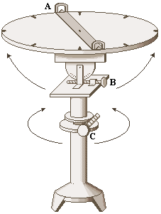
diagram of a dioptra:
|
The Roman architects in charge for this duty (the libratores) were very skillful in this kind of work, for which they used sophisticated tools: besides the ordinary level, similar to the one used today by carpenters, they used devices such as the chorobates and the dioptra. The former was a sort of bench with weighted strings on its sides for measuring the ground's angle on a system of notches, and a short channel in the center, likely for testing the direction of the water flow. The dioptra instead was a different kind of level: rested on the ground, and finely adjusted by tilting and rotating the top part by means of precision screws, it could assess the angle of a stretch of aqueduct by looking through pivoting sights. diagram of a chorobates:
|
|---|
Before being collected into the duct, the water passed through one or more pools, called piscinae limariae, where the speed of the flow would slow down, so that mud (limus) and other particles could settle.
 aqueduct
Similar pools or basins were also set along the course of most aqueducts, to remove any further impurity.
 |
Off the urban area most of the aqueduct's length ran underground: the adequate
level to mantain a sloping course was reached by digging vertical pits, and then the tunnel, or specus, was opened through the rock. In most cases the walls of the tunnel were lined with a waterproof facing, made of mortar mixed with tiny fragments of broken tiles and amphors, called opus signinum, 5 to 10 cm (2 to 4 in) thick. |
|---|
The average size of its section was about 1 m wide by 2 m in height (3 ft. by 6 ft.) , but these dimensions could considerably vary according to the expected water delivery of each single stretch. For instance, the one shown on the right (Aqua Marcia) measures 0.60 m by 1.35 m (2 ft by 4 ft 5 in).
|
 ↑ stretch of unbroken tunnel of the Aqua Marcia |
|---|


| Along the outer course of the aqueduct, every 240 feet (70 metres) a large stone marked the presence of the underground channel, and a safety distance of 5 feet (1.45 metres) from the course had to be kept free, to avoid damages or pollution. In fact, all aqueducts were public properties, owned by the government for the benefit of the citizens. The picture on the right shows one of these stones found by Porta Maggiore, near the site called ad Spem Veterem (see further in the page); its first words read HAC RIVI AQ(VARVM) TRIVM EVNT..., "here are the courses of three waters...", referring to the three aqueducts Aqua Marcia, Tepula and Iulia that reached this spot. Damaging the aqueducts or polluting the water was severely sanctioned, as well as drawing water for private mansions or grounds by illegally connecting a pipe to a public duct. Private branches did exist (see opening picture), but they were only allowed to use the water surplus, and a fee had to be payed for this facility. |
↓ stone indicating the presence of a nearby aqueduct |
|---|
Due to the ground's natural features, some parts of the duct had to follow the surface, along a trench whose sides were timbered (see below on the right).
 roof-shaped tunnel |
Stone slates covered the tunnel from being exposed to the direct sunlight, and from dirt, leaves, etc.; they were either flat, or rounded (dome-shaped), or formed an angle (roof-shaped).
|
 |
|---|

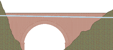
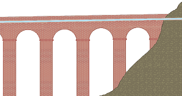
| When the duct reached a steep slope or a canyon, one solution was to build a bridge, or a viaduct, to cross the gap and reach the other side at a slightly lower level: here the duct's course would return underground. Another way by which such natural features could be crossed was the 'inverted siphon', a technique based on a simple physical principle. |
 |
|---|
 |
Just before the slope, the water was collected into a cistern, from which a pipe carried it to the bottom of the hollow by gravity, and then up again into a second cistern, thanks to the pressure generated along the first slope. A small viaduct was often built at the bottom of the hollow to reduce its maximum height, thus to minimize the water pressure needed to climb the opposite side. |
|---|
 earthenware pipes: each element fits into the following one (National Roman Museum Crypta Balbi section) |
The siphon was not often used for Roman aqueducts, because the pipes available by those times, either made of earthenware, with a sleeve and a groove at the opposite ends that enabled them to fit one into the other, or made of lead, kept together by a soldering, often rather roughly made, were not able to hold well the rather strong pressure generated by the slope, causing a substantial loss of water and requiring frequent repairs.
|
|---|


The architects, instead, more often preferred to lengthen the course of the aqueduct, sometimes quite considerably, so to follow the ground's natural features and constantly meet a regular slope.
 leaden water pipe, dating back to the 5th century (National Roman Museum - Crypta Balbi section) This explains why most aqueducts were much longer than the direct distance between their source and their urban outlet. An example is the case of the Aqua Virgo, shown in the map below, whose springs were located 10.5 Km (7 Roman miles) east of Rome, but whose aqueduct was 20.5 Km (14 Roman miles) long. |
 detail of the rough soldering on a leaden water pipe (on display in the subway station Manzoni) |
|---|
 remains of the Aqua Claudia off Torre Fiscale (in the background); here the aqueduct reaches 27 m (88.5 ft) in height |
 Where the ground turned flat, approaching the city, the water was kept flowing by building the famous series of archways, some of which reached almost 30 m (98 ft) in height. In fact, it was along these impressive structures that most aqueducts entered Rome. |
|---|
The higher the water travelled, the greater was the number of districts it could run to. They crossed the countryside for miles, keeping the water level high enough to reach the urban area.
| The core of the tall pillars was made of concrete (opus caementicium), i.e. a mixture of stones and mortar, and then faced in several ways for aesthetic purposes: either with ashlars made of tufa (opus quadratum, used for most aqueducts, up to the early imperial age), or with small square blocks of tufa arranged diagonally with alternate rows of brickwork (opus mixtum, used for the Aqua Traiana), or with bricks alone (opus latericium or opus testaceum, used for the Aqua Alexandrina). The upper part of the attic, corresponding to the roof of the tunnel, had a number of doors that allowed the same maintainance work needed by the underground tunnels. |
 |
|---|
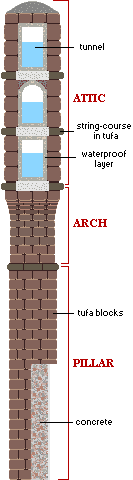 cross section of an average aqueduct |
|
|---|


Once an aqueduct reached the urban area, its main outlet was located somewhere by the city's highest spots. In particular, most of them approached Rome from the south-east, in a place known as ad Spes Veterem ("by the Old Hope"), after an ancient Temple of Hope that once stood there. The water then entered Rome from the nearby Esquiline Hill, from where most other parts of the city could be served.
 |
In some cases, 'richer' aqueducts helped others to mantain a sufficient water volume for the districts they supplied: for instance, the Aqua Claudia poured about 1/8 of its total flow into the Aqua Iulia and Aqua Tepula.
|
|---|


Not all aqueducts entered Rome above an aqueduct: the earliest one, Aqua Appia, ran almost completely underground, as well as the ones coming from the north-west, Aqua Alsietina and Aqua Traiana, which supplied the 8th regio, Transtiberim (i.e. Trastevere district), from the top of the Janiculum Hill.
| In such cases, within the urban area the lapides perterebrati were used: special blocks of tufa crossed by a clay pipe; their shape was specially designed with a sleeve on one end, so to fit one into the other. They could either carry a leaden water pipe, or directly water (in which case their inner surface was lined with a waterproof layer). Many of these blocks have been found in archaeological excavations, allowing the identification of several underground ducts mentioned by literary sources. |
 diagram of the lapides perterebrati |
|---|
The Aqua Alsietina, the earliest of the two western aqueducts (2 BC), drew water from a small lake north of Rome called Lacus Alsietinus (now Lago di Martignano). This water was not suitable for drinking: emperor Octavianus Augustus used it only to fill his naumachia in Trastevere, where he and the public enjoyed naval battles, and for the irrigation of Caesar's Horti (gardens), in the same district.
 |
The one built by Augustus was not the only naumachia in Rome: a number of them was known to exist, although all of them have disappeared in time, and only fictional reconstructions of their shape can be found in old etchings and paintings, such as the ones shown on either side. Nevertheless, this gives an idea of the enormous amount of water available in ancient Rome. |  |
|---|
The main outlet of an aqueduct came in the shape of a castellum ("castle"), a structure of variable size with one or more chambers similar to the piscinae limariae, where the water flow slowed down and the last impurities settled.
| The water was then poured outside through a number of chalice-like nozzles. Most castelli looked like simple prysms, but a few of them were shaped as fountains, sometimes decorated with statues, reliefs or mosaics (nymphaeums). Wardens patrolled them, to avoid any tampering of the ducts or pollution of the water. These ones too sometimes had further branches, and ended with smaller 'castles', or directly served public baths, fountains, etc.: ancient Rome was actually crossed by a complicated network of water ducts. From the main castellum, other parts of the city were reached by means of smaller branches of the aqueduct, either along an elevated viaduct or an underground channel, always following a sloping route, as the main one. |
 a 'castle', highlighted in yellow, pouring the A.Iulia or A.Tepula next to Diocletian's Baths (from E.Du Perac's map of ancient Rome, 1574) |
|---|


diagram of a standard outlet:
A - main duct B - 'castle' C - secondary branch D - nozzle
|
 part I |
 part III |
 part IV |
 |
|---|