 |
  |
  |
|---|
~~~ part 1 ~~~
 Moses (from the tomb of Julius II) |
BOUNDARY piazza del Colosseo; via dei Fori Imperiali; piazza Madonna di Loreto; vicolo San Bernardo; via Magnanapoli; via XXIV Maggio; via del Quirinale; via delle Quattro Fontane; via Agostino Depretis; piazza Esquilino; via Esquilino; piazza Santa Maria Maggiore; via Merulana; piazza di San Giovanni in Laterano; the Lateran complex (within Aurelian's Wall) *; via della Ferratella; piazza di Porta Metronia; via della Navicella; via Santo Stefano Rotondo; via Oliviero Plunkett; via di San Giovanni in Laterano. * today the Lateran complex is cut off; it can be bypassed along via dell'Amba Aradan and via dei Laterani, or alternatively along piazzale Appio, via Sannio, via Farsalo, and piazzale Ipponio |
|---|

 |
MAIN FEATURES (the black numbers in square brackets refer to the map on the left) Monti is Rome's largest district, which up to the late 1800s included also a large part of the present Esquilino (XV) and Celio (XIX) districts. Most of its streets have been planned again and rebuilt in the late 19th century, yet preserving many interesting relics, that range from remains of the imperial age to medieval and Renaissance churches and basilicas. From a physical point of view, Monti is a particularly hilly district, as claimed by its own name: it stretches from the southern side of the Quirinal to the Viminal, and then to the Esquiline, including also a small part of the Coelian Hill. The Esquiline is a larger hill than the others, with three different peaks, called Cispius, Fagutal and Oppius (see small map below), on each of which features of interest can be found. |
|---|
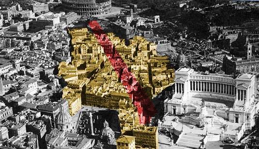
 |
Its odd shape, with a projection towards the south-east surrounding St.John in the Lateran [11], is due to the fact that when Esquilino district (1874), and then Celio district (1921) were established, Monti's original area was nibbled on both sides, leaving a central strip that joins the remaining part of the Rione I. The enormous historical and artistic background of this rione makes Monti almost a small city of its own in the heart of the larger urban area. This is testified by the particular privilege that in the past centuries was granted to the local district master (see general notes), who was admitted among the city's administrators. Monti's inhabitants, very proud of their status, traditionally claim to be 'more genuinely roman' than those of any other district; in the old days they even used to speak a particular variety of Rome's dialect, called monticiano, which today is no longer heard. |
|---|
There is no specific route for visiting Monti: the sequence of spots described in this page is based on several themes that can be found in this district, but it should not be considered as a fixed direction. For instance, the tour can start from its western end, occupied by a large complex [1] built under emperor Trajan (c.AD 110): the forum (which included a wide plaza, a basilica, two libraries and a temple, whose scanty remains today are a few columns and some fragments of its marble paving), and the market at the back. The latter, instead, is still rather well preserved, and it brings an amazing flashback of everyday's life in ancient Rome: its many shops, arranged on different levels, make this place, already active almost 2.000 years ago, a forerunner of modern shopping alleys. It was crossed throughoutly by a paved street called via Biberatica, which is still extant. |
 the ancient via Biberatica crossing Trajan's Markets |
|---|
 |
The market stands next to the Imperial Fora, i.e. the series of fora named after dictator Julius Caesar and emperors Trajan, Augustus, Nerva and Vespasian; all together they stretched for about 400 metres (¼ mile) towards the Colosseum [4]. They were all built within the time length of 150 years, from 46 BC to AD 113, along the free space left along the north-eastern side of the Roman Forum. The complex sponsored by Trajan was the last one to be built, and also the largest of them all; for its making, architect Apollodorus of Damascus partly cut the nearby Quirinal Hill and levelled the ground at its base; the multi-storey market located at the back was, in fact, stategically placed there, so to act as a buttress and prop the aforesaid hill, preventing it from collapsing. ← the extension of the Imperial Fora (in blue) compared to the modern city: A) Forum of Trajan, B) Forum of Caesar, C) Forum of Augustus, D) Forum of Nerva, E) Forum of Vespasian (Temple of Peace); the open area below is the Roman Forum |
|---|
 |
 |
|---|
The only relic in these fora that is still almost perfectly preserved is the famous column of emperor Trajan [2] covered with spiral reliefs. It consists of eighteen huge hollow cylindres of white marble resting one on top of the other, with an inner staircase that reaches the top, given light by tiny windows along the shaft. The height of the monument, including its huge pedestal, is 40 m (135 ft), but the column alone is slightly less than 30 m, corresponding exactly to 100 Roman feet.
 Trajan's Column |
The reliefs, that wind along the shaft, from the base to the top, tell the story of Trajan's campaign against the Dacians (i.e. the inhabitants of today's Romania).
|
|---|


By the late 1500s, when the Fora were in ruins and mostly buried, the area became the property of a cardinal, Michele Bonelli (a nephew of pope Pius V), better known as cardinale alessandrino, as he came from Alessandria (in Piedmont region, north-western Italy). Over the Roman remains, he built a whole neighbourhood that became known as the Quartiere Alessandrino, after him.
 the no longer extant Quartiere Alessandrino, highlighted in yellow, around 1920: via dell'Impero (later via dei Fori imperiali) was opened along the red line |
The Quartiere Alessandrino stood up to the early 20th century. Then, between 1924 and 1932, it was razed to the ground for the opening of the wide via dei Fori Imperiali, whose first name was via dell'Impero. At the same time, an excavation campaign was conducted over the area, unearthing several remains of the Fora. Today the foundations of the old houses and some parts of their basements can be seen, on the edge of the actual archaeologic area, along via Alessandrina, which was the main street of the neighbourhood and today is left a strip of paved ground that crosses the ruins. |
|---|
| At the back of Trajan's Market, the leaning yet still imposing remains of Torre delle Milizie overlook the complex: it is one of the city's tallest medieval towers, built in the mid 1200s, whose top part collapsed only one century after being finished due to a strong earthquake in 1368. According to a popular tradition, this is the site where emperor Nero enjoyed the view of Rome ablaze, during the great fire of AD 64, while he played his lyre. |  via dei Fori Imperiali today |
|---|
During the Middle Ages, hudreds of towers (most of which smaller than this one) crowded Rome's skyline; all powerful families owned at least one, and the more important was the family, the thicker and taller was the building.
 |
About a hundred of them were demolished in 1257, when a senator who came from Bologna, Brancaleone degli Andal�, tried to quell the centuries-long civil war between the noble families that backed the emperor and the ones sympathetic to the pontiff; as a result, he was attacked twice and even imprisoned for some months. Once back in charge, the senator had the towers of several families taken down by decree. Pope Alexander IV, who had meanwhile fled to Anagni (60 km or 35 mi south-east of Rome), issued an excommunication against the senator for doing so, but then lifted it when Brancaleone threatened to raze Anagni to the ground. ← Trajan's market, overlooked by Torre delle Milizie |
|---|
Today about thirty surviving towers can be seen scattered over the city's historical districts; Monti is the one where the largest number of them is found.
| Another famous one is Torre dei Conti [5] (13th century), at the southern end of the Imperial Fora, once almost twice as tall as now, thus considered one of Rome's marvels, and mentioned by Petrarch. Two more of similar age stand on the Cispius peak [6], facing each other; they belonged to the Arcioni family, then handed down to the Capocci (the taller of the two), and to the Cerroni family, before the Graziani purchased it. |  Torre delle Milizie |
 the broken Torre dei Conti |
 Torre degli Arcioni, then Capocci |
|---|
The rear part of the Forum of Augustus is occupied by a late medieval building, the House of the Knights of Rhodes [3]. This Order, also known as the Knights Hospitaller, was founded in the 12th century, by the time of the crusades; initially, it only provided medical care for pilgrims travelling to the Holy Land, but after some time it also provided them with an armed escort, a task performed jointly with the Knights Templar. Then, after the fall of Jerusalem, the Hospitallers had to seek shelter in Cyprus at first, then in Rhodes, where they took the name from the island. In 1312 the Templars were officially disbanded, and their possessions were handed over to the Hospitallers, who over the 14th and 15th centuries became one of the most powerful Orders, also economically. After the Protestant Reformation and the Anglican schism, the Knights of Rhodes changed their seat again, reaching Malta in 1530: henceforth, they became known as the Knights of Malta. Once driven away from the island in 1798 by Napoleon I, the Order dissolved, and reconstitute once again over the 19th century with the name Sovereign Military Order of Malta, which still today manages hospitals and welfare services.
 the House of the Knights of Rhodes from the archway of Salita del Grillo |
|
|---|

In 1566 the seat of the Hospitallers was moved to the Aventine Hill; the House of the Knights of Rhodes was then turned into a nunnery of Dominican nuns called Neophytes, as their task was to convert Jewish girls to the Catholic religion. No sooner than 1946 the building was handed back to the original owners (now S.M.O.M.).
The back of the House of the Knights of Rhodes stands along the steep Salita del Grillo, a narrow street named after a noble family, whose 18th century family mansion stands there, connected to another medieval tower (Torre del Grillo) by means of an archway.
The area at the back of the Imperial Fora was known as the Subura or Suburra [7] (from the Latin sub urbs, i.e. "on the fringes of the city").
 plaque dating to the late 1400s in the heart of the Suburra |
In ancient Rome, it was an ill-famed district built on a swampy ground, whose slums were inhabited by outlaws and prostitutes. The present look of the Suburra dates to the 15th-17th centuries, when once again regular houses were built there. The deep alterations carried out to Monti district by the end of the 19th century partly spared this neighbourhood, where several old buldings were preserved. The typical narrow and sometimes crooked lanes, constantly sloping due to the hilly ground, are crossed by a few long and straight streets opened by pope Sixtus V in the late 1500s. One of them is via Panisperna (picture on the right). In ancient times, the local church of St.Laurence used to offer the poor bread and ham (in Latin, panis et perna) on the saint's day, whence the name of the street, whose up-and-down course follows the shape of the district's hills. |
 via Panisperna: its ups and downs run from the top of the Cispius peak to the Fagutal peak |
|---|
On the top of the Fagutal, the westernmost peak of the Esquiline Hill, stands the church of San Pietro in Vincoli [8], or St.Peter in Chains, originally built in the 5th century; it holds the sets of chains believed to have restrained St.Peter while held in prison, in Palestine and then in Rome. The relics are displayed in a crystal case below the main altar. But the most visited feature of this church is the tomb of pope Julius II, one of the major works by Michelangelo, which includes the famous sitting figure of Moses.
|

| In the original project, Moses sat frontwards, in a straight, symmetrical posture, still according to a late medieval scheme; finding it too conventional for his taste, the artist changed the attitude of the figure while he was already carving it, choosing a more dynamic position. The extreme difficulty of using the same marble, already partly shaped, to obtain a diffent figure was tackled by Michelangelo with great skill; the size of the new statue was slightly shrinked, its head was partly rotated, with the tip of the old nose turned into the new figure's cheekbone, the left leg was flexed backwards to disguise the slightly smaller size than the other one. The body of Julius II, embalmed and kept in the Vatican basilica while the tomb was being built, suffered severe damages during the sack of Rome in 1527; what could be retrieved of his remains was finally buried by his monument in 1610. A legend says that the fidgety Michelangelo, yet pleased for the final result of his work, hit the knee of the statue with a hammer, shouting "Why don't you talk?". The monument, though, 'patched up' so many times, represented one of the artist's greatest regrets. |
 the tomb of Julius II |
|---|
The square where St.Peter's church stands (from where another medieval tower can be seen, Torre degli Annibaldi, built in the 1200s over the remains of a Roman nymphaeum) can be reached from via Cavour by means of a steep flight of steps; the staircase cuts like a tunnel below an old complex of buildings, consisting of an early 16th century house and a further tower, of the same age as the previous one. In ancient Rome this was the site of an alley called vicus sceleratus ("wicked lane") because traditionally believed to be the place where in 535 BC, Tullia, daughter of Servius Tullius (sixth king of Rome) and wife of Tarquinius the Proud (seventh king), drove her chariot over the body of her own father, upthrown by Tarquinius, killing him.
 the so-called houses of the Borgias |
The gloomy memories of this place probably inspired another popular belief, concerning the building above the flight of steps: it is said that the famous Lucrezia Borgia, daughter of pope Alexander VI (Rodrigo Borgia), used to poison her lovers in this house. The complex is, in fact, still popularly known as 'the houses of the Borgias'. There is no historical evidence, though, that any member of the family really lived here. The house belonged to the Cesarini family, who in time donated it to the local convent. |  Torre degli Annibaldi |
|---|
 |
|
|
|---|