 |
 THE RIONI Rome's Historical Districts |
  |
|---|
INTRODUCTION
 a typical district plaque |
Since its earliest days, Rome has always been divided into administrative districts, which in time led to a carachterization of each of them, particularly from a social point of view, but also historically and culturally. The following pages are an attempt to describe the oldest and more central fourteen districts by sketching their historical notes and their main features, with plenty of curiosities, legends, and other unusual information. They should not be read as a guidebook, since the city's most renowned highlights have been barely mentioned, and to include every single detail worthy of being described would have made these pages too bulky. However, not the famous buildings, churches and monuments are the real subject of these pages, but the districts they belong to, as a whole, with the peculiar atmosphere that each of them boasts. |
|---|
In order to easily locate each site, the name of the street or square where the feature is located will appear by running the mouse's cursor over the relevant picture.
For a general introduction to Rome's districts, keep scrolling down this page below the index, or click here.
Lastly, a brief note about the background texture chosen for these pages. It features Rome's typical cobblestones, vaguely reminiscent of the larger and more irregular ones used in ancient times. Still nowadays, these heavy blocks of basalt are the most common form of paving found all over the city. They measure 12 × 12 cm (4¾ × 4¾ in) and sink into the ground for 17 cm (6 inches), laid one by one as in a mosaic.
 sampietrino cobblestone |
They are locally known as sampietrini because they were first adopted in the mid 16th century for St.Peter's Square (although the earliest ones were about half the size of the stones found today), and then they were gradually used all over the city. They used to be hand-made by a team of stone-masons known as squarcioni (i.e. "smashers"), who break the large blocks of basalt, scoccioni ("chippers"), who give the stones a prysmatic shape, and posatori ("layers") also called battiserci ("stone hammerers"), who do the last part of the job. |  |
|---|
(clickable map)
|
|
|---|
the location of some among Rome's main sites of interest
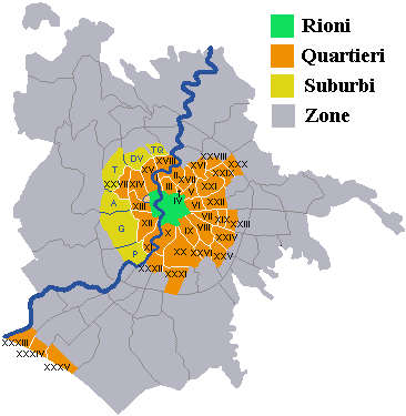
For the sake of completeness, the following map shows the full extension of Rome's municipality; the table lists the quarters (districts immediately outside the city's historical nucleus) and suburbs (districts further off the center). The outer parts are divided into zones.
|
  |
|---|
| ZONE I - Val Melaina II - Castel Giubileo III - Marcigliana IV - Casal Boccone V - Tor San Giovanni VI - Settecamini VII - Tor Cervara VIII - Tor Sapienza IX - Acqua Vergine X - Lunghezza XI - San Vittorino XII - Torre Spaccata XIII - Torre Angela XIV - Borghesiana XV - Torre Maura |
XVI - Torrenova XVII - Torre Gaia XVIII - Capannelle XIX - Casal Morena XX - Aeroporto di Ciampino XXI - Torricola XXII - Cecchignola XXIII - Castel di Leva XXIV - Fonte Ostiense XXV - Vallerano XXVI - Castel di Decima XXVII - Torrino XXVIII - Tor de' Cenci XXIX - Castelporziano XXX - Castelfusano |
XXXI - Mezzocamino XXXII - Acilia Nord XXXIII - Acilia Sud XXXIV - Casalpalocco XXXV - Ostia Antica XXXVI* - Isola Sacra XXXVII* - Fiumicino XXXVIII* - Fregene XXXIX - Tor di Valle XL - Magliana Vecchia XLI - Ponte Galeria XLII* - Maccarese Sud XLIII* - Maccarese Nord XLIV - La Pisana XLV - Castel di Guido |
XLVI* - Torrimpietra XLVII* - Palidoro XLVIII - Casalotti XLIX - Santa Maria di Galeria L - Ottavia LI - La Storta LII - Cesano LIII - Tomba di Nerone LIV - La Giustiniana LV - Isola Farnese LVI - Grottarossa LVII - Labaro LVIII - Prima Porta LIX - Polline Martignano * off the map, now belonging to Fiumicino |
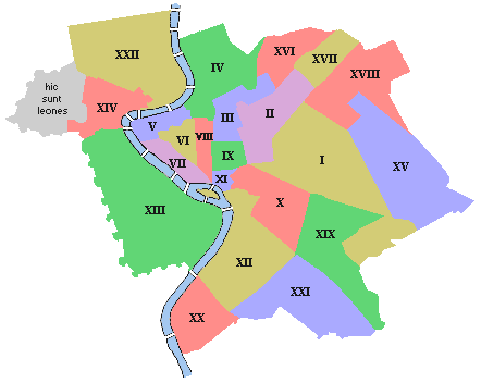
Rome's historical nucleus is divided into 22 districts called rioni. The name is a corruption of the Latin word regiones, i.e. the subdivisions first decreed by king Servius Tullius, around the 6th century BC, into which the city had been arranged. They were originally four:
All four regions were included in the pomerium, the city's sacred boundary that the same king had marked by means of large stones (blue dots in the map, see The City Walls for more details).
DISTRICT NAME / REFERENCE Regio I Suburana Subura district (from sub urbs = "city fringes", including the Caelian Hill) Regio II Esquilina Esquiline district (ex quiliae = "out of the built-up area") Regio III Collina Hill district (comprising two hills, namely the Quirinal and the Viminal) Regio IV Palatina Palatine district (comprising the Palatine Hill and the Roman Forum)
The Capitolium Hill (C in the map) was likely considered a sacred area of its own, as the main Temple of Jupiter and other temples stood there, thus despite not being counted among the regiones, it was enclosed within the pomerium all the same. When the first set of city walls (the so-called Servian walls) was built around the mid 4th century BC, during the Republican age, Rome has already stretched well beyond the sacred boundary.
 the first four Regiones of king Servius Tullius ██ Republican Rome (Servian walls) ▪ ▪ ▪ ▪ ▪ the pomerium |
 the fourteen Regiones of Octavian Augustus ██ Imperial Rome (Aurelian's walls) ██ Republican Rome |
|---|
At the beginning of the Imperial age, since the city kept growing, Octavian Augustus, (27 BC-14 AD), raised the number of regiones to fourteen by including among them the areas that meanwhile had been populated outside the extant Servian walls. However, the making of a new set of walls took place no sooner than almost three centuries later, under Aurelianus. The names of the regiones were referred to the main features of each district, although also their number was commonly used:
| DISTRICT | NAME / REFERENCE FEATURE | |
|---|---|---|
| Regio I | Porta Capena | Capena Gate (the southernmost gate of the Servian Wall) |
| Regio II | Caelemontium | the Caelian Hills (the Coelian and its minor reliefs) |
| Regio III | Isis et Serapis | (Egyptian gods to whom a famous temple was dedicated) |
| Regio IV | Templum Pacis | Temple of Peace |
| Regio V | Esquiliae | Out of the Built-up Area |
| Regio VI | Alta Semita | High Semitic district |
| Regio VII | Via Lata | (the old name of via Flaminia within Rome's boundary) |
| Regio VIII | Forum Romanum vel Magnum | the Roman Forum (or Great Forum) |
| Regio IX | Circus Flaminius | Flaminius' Circus |
| Regio X | Palatium | the Palace |
| Regio XI | Circus Maximus | the Greatest Circus |
| Regio XII | Piscina Publica | Public Pool |
| Regio XIII | Aventinus | Aventine Hill |
| Regio XIV | Transtiberim | Beyond the Tiber (the river's western bank) |
Further destructions and alterations were suffered by Rome over the early Middle Ages, with the Gothic Wars and the barbaric invasions. As the Roman Empire crumbled, also Rome's administration gradually lost power. An unofficial subdivision of the urban territory based on religious jurisdiction (i.e. parts of the city, also called Regiones, which referred to the main local churches that acted as parishes) began to come into practical use, as early as the 4th century. It comprised the following seven districts:
| DISTRICT | NAME / REFERENCE FEATURE | |
|---|---|---|
| Regio I | Aventinensis vel Horrea | of the Aventine or the Wheat Deposits |
| Regio II | iuxta IV Coronatorum... | by [the church of] the four Crowned [Saints]... |
| Regio III | iuxta porta Maiore | by Porta Maggiore (a.k.a. Porta Praenestina) |
| Regio IV | qui appellatur Campum Sanctae Agathae | which is called Field of St.Agate |
| Regio V | iuxta arco marmoreo | by the marble arch (no longer extant, along via Lata, now via del Corso) |
| Regio VI | ad Sancta Maria in Sinikeo | by St.Mary in Sinikeo's |
| Regio VII | ad Sanctum Petrum | by St.Peter's (corresponding to the old Regio XIV, Transtiberim) |
Despite the new religious arrangement, for several centuries the original Regiones established by Octavian Augustus were not officially discontinued; but the more time elapsed, the more things got mixed up.
A document issued by pope Leo VIII (963-964) mentions the representatives of fifteen Regiones, whose names appear to be a blend of the old administrative and religious ones described so far. They were likely used unofficially, i.e. not for administrative nor for religious purposes, but only to indicate a district after its main landmark. Only three of such names mention the Regio's ordering number, while for all the others this remains unclear.
NAME / REFERENCE FEATURE | ||
|---|---|---|
| Regio prima Aventini | first District, of the Aventine | |
| Regio secunda Mamertini | second District, of the Mamertine [1] | |
| Regio optava sub Capitolio | eighth District, below the Capitolium (the Roman Forum area) | |
| Regio de Vico Patricii | District of Patricii Lane (unidentified location) | |
| Regio Caput tauri | Bull's head District (Tiburtina Gate) | |
| Regio clivi argentarii | District of the Silversmiths' Ramp | |
| Regio ad duos (amantes) | District by the two lovers (unidentified location) | |
| Regio liberatica | Liberatica District [2] | |
| Regio Sisinii | District of Sisinius (unidentified location) | |
| Regio via Lata | District of Lata Street | |
| Regio Coelio Monte | Caelian Hill District | |
| Regio urbis Ravenne | District of the city of Ravenna (Trastevere) [3] | |
| Regio ad gallinas albas | District by the white hens [4] | |
| Regio horrea | District of the wheat deposits (Aventine Hill) | |
| Regio secus porta Metronii | District along Metronia Gate |
notes 1. - After the Mamertine Prison, by the northern end of the Roman Forum, where according to a legend St.Peter had been held. 2. - A corruption of 'Biberatica', the name of an old Roman street that crossed Trajan's Markets, also used as a district landmark in the 14th century (see further). 3. - In Trastevere, the military corps from Ravenna had a camp. 4. - After the name of an old church, St.Sixtus ad gallinas albas, corresponding to the present via Panisperna. |
 |
In 1144, the Senators, who by that time ruled the city, decided to rearrange Rome's inhabited territory (much smaller than in ancient times) into twelve districts, still called regiones in official documents, though no longer including the Tiber Island nor any area on the western side of the river. In fact, Trastevere - "beyond the Tiber" - entered again the official list of districts only in the early 14th century. No trace of this new arrangement is found yet in the early editions of the Mirabilia Urbis Romae ("wonders of the city of Rome"), a famous list and guide of the city's main features, written in Latin around the mid 12th century for the benefit of the many pilgrims who came to Rome, to visit St.Peter's tomb.
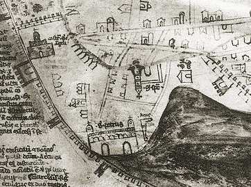
← a section of the map of Rome by Friar Paolino (c.1340), pointing to the east, which shows the
southern districts of the city: in the centre run the arches of the aqueduct branch built by Nero,
starting by the church of Santa Croce in Gerusalemme; below the latter is the Lateran area with
St.John's basilica, and the mounted statue of Marcus Aurelius and the fragments (head, hand) of the
huge statue of Constantine, now both held in the Capitoline Museums; further down is the dark
shape of the Caelian hill; on the far right run Aurelian's city walls; top left is the Esquiline hill with
St.Mary the Major's; finally, bottom left stands the Colosseum with a curious dome, likely an attempt to depict the velarium |
|---|
Instead Le miracole de Roma ("Rome's wonders"), which is basically a translation of the aforesaid Mirabilia guide into archaic Italian, with some new parts added, roughly dating to the 13th century, mentions a division into twelve districts:
la casa de lo Honore et de la Virtute, .... |
First District: Capena Gate, where the house of Honour and Virtue stands... |
lo Macello de Claudio et lo maiure vordello de Roma, .... |
Second District: Caelian hill, where Claudius' Slaughterhouse and Rome's main brothel stood... |
lo Palazo de Yside et de Serapis, .... |
Third District, where the Palace of Isis and Serapis stood... |
| Fourth District, where the temple of Peace stood... |
|
lo Pozo de Orpheo et lo Macello de Laviano .... |
Fifth District, where Orpheus' Well and Lavianus' Slaughterhouse stood... |
lo Templo de Salustio et de Serapis .... |
Sixth District: High Road, where the Temple of Sallust and Serapis stood... |
lo quale avea lo Pozo de Ganimede .... |
Seventh District: Lata Street, which had Ganymede's Well... |
| Eighth District: Rome's Main Market... | |
et avea la Casa de Romulo .... |
Ninth District: the Great Palace, and it had Romulus' House... |
et Templum Mercurii .... |
the Tenth District had the Temple of the Sun and the Moon, and the Temple of Mercury... |
| Eleventh District: Public Pool... | |
| Twelfth District: Aventine... | |
| the Thirteenth District is Trastevere... |
| The list clearly shows how the ancient arrangement by Augustus, looked at as the 'classic' one by scholars, was still used for cultural purposes, despite having lost administrative and bureaucratic effectiveness.
another part of the map by Friar Paolino, featuring →
the Vatican, with St.Peter's (bottom) and the obelisk on its right side; in the top left corner is the Castle, the dark shape on the right is the Janiculum Hill In a late edition of the Mirabilia guide, dating from 1220-26, found in an Austrian library, a rather complex arrangement into 26 districts is mentioned. |
 |
|---|
| Prima regio dicitur porticus Sancti Petri, | The first district is called St.Peter's porch [1] |
| secunda pons Sancti Petri, | the second (is called) St.Peter's bridge |
| III scorteclari | the 3rd, the skinners |
| IV parrio | the 4th, Parione [2] |
| V Sanctus Laurentius in Damaso | the 5th, St.Laurence in Damaso |
| VI campus Martis, | the 6th, the Field of Mars |
| septima Sanctus Laurentius in Lucina, | the seventh, St.Laurence in Lucina |
| octava columpna Antonini coclidis, | the eighth, the spiral column of Antoninus |
| IX Sancta Maria in Aquiro, | the 9th, St.Mary in Aquiro |
| X Sanctus Eustachius, | the 10th, St.Eustachius |
| XI vinea Tedemari, | the 11th, Tedemarius' vineyard |
| XII Areola, | the 12th, Small Area (unidentified location) |
| XIII Caoccavaia, | the 13th, Caoccavaia (unidentified location) |
| XIV S.Angelus piscivendoli, | the 14th, St.Angel of the fishmongers' |
| Quintadecima Pinea, | the fifteenth, Pine-cone |
| Sextadecima S.Marcus, | the sixteenth, St.Mark |
| VIIdecima Trivium, | the 7teenth, Three-way Junction |
| Octadecima Violata, | the eighteenth, Violata [3] |
| Nonadecima Campitellus, | the nineteenth, Campitelli |
| Vicesima S.Adrianus, | the twentieth, St.Hadrian |
| Vicesima I Biberatica, | the twenty-1st, Biberatica [4] |
| Vicesima II Montes vel Lateranum, | the twenty-2nd, the Hills or the Lateran |
| Vicesima III Ripa, | the twenty-3rd, River Bank | Vicesima IV Marmorata, | the twenty-4th, Marmorata | Vicesima V Insula, | the twenty-5th, the Island | Vicesima VI Transtyberim, | the twenty-6th, Beyond the Tiber |
notes |
Interestingly, two among the aforesaid landmarks, namely the first and the second ones in the list, were located by the Vatican Hill, despite in the 1200s this area was not yet officially part of Rome's urban area.
A catalogue of Rome's churches compiled in early Italian one and a half centuries later, in the late 1300s, mentions again the names of the districts, reveals that an evident change had occurred by that time, as shown in the table below.
 map of Rome's highlights dated 1472, looking southwards; Leo's City (bottom right corner) was still a separated citadel |
This text (featured in the next table) starts with the following lines:
In the city are thirteen districts which, using a corrupted and popular term, are referred to as 'Rioni'. The first one of them is the district of the Hills and Biberatica (Street).Therefore, despite the ordering had changed, the use of mentioning an outstanding local feature or landmark besides the name of the district, was still maintained for some time. Such additional reference often was the district's main church. |
|---|
This arrangement is not only the one in which the word Rioni is first mentioned, but also the one whose names are basically the same ones presently in use, although their boundaries partly mismatched. The following table compares their names and their ordering.
OF THE DISTRICTS |
OF THE SAME THIRTEEN DISTRICTS |
|
|---|---|---|
In urbe sunt Tredecim Regiones. Que corrupto et vulgari vocabulo dicuntur Rioni. |
||
| Quarum Prima est Regio Montium et Biberate. The first of which is the district of the Hills and Biberatica (Street). |
I. Monti (matching) | |
| Secunda. Regio Trivi et Vielate. Second. District of the Three-way Crossing and Lata street. |
II. Trevi (matching) | |
| Tertia. Regio Colupne et sancte Marie in Aquiro. Third. District of the Column and St.Mary in Aquiro's. |
III. Colonna (matching) | |
| Quarta. Regio Posterule et sancti Laurentii in Lucina. Fourth. District of the Small Gate and St.Laurence in Lucina's. |
IV. Campo Marzio | |
| Quinta. Regio Pontis et Scortichiariorum. Fifth. District of the Bridge and the Skinners. |
V. Ponte (matching) | |
| Sexta. Regio sancti Eustachii et vinee Tedemarii. Sixth. District of St.Eustachius' and Tedemario's wineyard |
VI. Parione | |
| Septima. Regio Arenule et Chacabariorum. Seventh. District of Arenula and the Pot-makers |
VII. Arenula (matching) | |
| Octava. Regio Parionis et sancti Laurentii in Damaso. Eighth. District of Parione and St.Laurence in Damaso's |
VIII. Parione | |
| Nona. Regio Pinee et sancti Marci. Ninth. District of the Pine-cone and St.Mark's |
IX. Pigna (matching) | |
| Decima. Regio Sancti Angeli in foro piscium. Tenth. District of the Holy Angel in the fish-market |
X. Campitelli | |
| Undecima. Regio Ripe et Marmorate. Eleventh. District of the River Bank and Marmorata |
XI. Sant'Angelo | |
| Duodecima. Regio Campitelli in sancti Adriani. Twelfth. District of Campitelli by St.Hadrian's |
XII. Ripa | |
| Tertiodecima. Regio Transtiberim. Thirteenth. District beyond the Tiber |
XIII. Trastevere (matching) |
 |
Among the present districts, seven have a matching name and ordering, and five of them have a matching name but their sequence is different; only one (Campo Marzio) has a different name. These names also show that the ones found in the long 26-entry list of the late Mirabilia edition hel in Austria, previously described, might have been based on a misinterpretation, i.e. by splitting the same twelve double names into twenty-four separate entries. Likely during the late Middle Ages, the coats of arms representing the districts developed their shapes, which have remained unchanged. ← description of the coats of arms of the districts, in a pubblication dated 1545; the rioni are not listed according to their number, and Borgo is still missing |
|---|
| By the late 16th century, also Leo's City (i.e. the Vatican area), which up to those days had been a suburban enclave, yet already surrounded by a set of walls since the time of pope Leo IV (847-855), was officially included by Sixtus V (1585-90) within Rome's urban territory, thus becoming the fourteenth rione. In 1743, pope Benedict XIV reorganized the fourteen rioni; in the following year the districts were marked by means of 220 marble plaques, hung along the streets where their new boundaries ran. Half a century later, when Rome was first occupied by Napoleon's army, an ordinance was issued by means of which the city's administrative areas were renamed Sezioni ("sections"); their names changed, and some of them were merged together, while others were split, according to the following table. the ordinance issued the 16th of Vent�se (March 6th according to → the French Republican Calendar), 1798; click on the image to enlarge it |

|
|---|
I. Rione Monti (split into two parts) " " II. Rione Trevi III. Rione Colonna IV. Rione Campo Marzio V. Rione Ponte VI. Rione Parione plus VII. Rione Regola VIII. Rione Sant'Eustachio IX. Rione Pigna plus XI. Rione Sant'Angelo X. Rione Campitelli plus XII. Rione Ripa XIII. Rione Trastevere XIV. Rione Borgo |
→ → → → → → → → → → → |
Sezione delle Terme Sezione della Suburra Sezione del Quirinale Sezione del Pincio Sezione di Marte Sezione di Bruto Sezione di Pompeo Sezione di Flaminio Sezione del Pantheon Sezione del Campidoglio Sezione del Gianicolo Sezione del Vaticano |
Section of the Baths Section of the Suburra Section of the Quirinal Hill Section of the Pincio Hill Section of Mars Section of Brutus Section of Pompeus Section of Flaminius Section of the Pantheon Section of the Capitolium Hill Section of the Janiculum Hill Section of the Vatican Hill |
|---|
The French admnistration also removed all the extant district plaques.
Once the occupation was over, in 1814, the old division in fourteen Rioni was restored, as well as their original boundaries, which ever since never changed. The plaques were placed again along the streets, and most of them can still be seen on many old buildings; some of them have been cleaned and restored, while others show heavy signs of ageing.
Shortly after the fall of the Papal State (1870), Rome's administrators grouped them into larger administrative districts, for which the old term Regioni (i.e. Italian for Latin Regiones) was retrieved:
| CLUSTER | DISTRICTS COMPRISED | |
|---|---|---|
Regione I, Campidoglio |
I. Monti plus X. Campitelli | |
| Regione II, Pantheon | II. Trevi plus VI. Parione plus VIII Sant'Eustachio plus IX. Pigna | |
| Regione III, Campo Marzio | III. Colonna plus IV. Campo Marzio | |
| Regione IV, Adriana | V. Ponte plus VII. Regola plus IV. Borgo | |
| Regione V, Tiberina | XI. Sant'Angelo plus XII. Ripa plus XIII. Trastevere |
This arrangement though did not last very long, and was discontinued before the turn of the century; the Rioni soon turned again into fourteen individual administrative units.
In 1874, the largest district, Monti (I), was split into two halves: the central part kept its name, while the eastern part, which was being repopulated, became the rione Esquilino (XV).
Curiously, in this administrative subdivision, the many roman bridges (today no less than fourteen of them span the Tiber in the city's historical centre enclosed by the ancient set of Aurelian's walls) represent 'free zones', as well as the course of the river, officially not belonging to any of the rioni, since the boundaries always run along the streets that follow the Tiber banks (lungoteveri), on the relevant side of the district. For historical reasons, Sant'Angelo Bridge represents an exception; despite Ponte district took its name from this bridge, as of the late 1500s it actually belongs to Borgo. In spite of Rome's continuous expansion - since the 1920s the size of the city has more than tripled - no further district was given the qualification of rione: the modern urban areas were divided into quartieri (quarters), whose number reached 35, suburbi (suburbs), presently 6, and 51 zone, larger areas in the city outskirts, in constant expansion (see again the map). In the past, the sense of belonging to one's own rione was strongly felt by the local inhabitants. The district used to be the context where the common people spent most of their life. |


In each rione a certain hierarchy existed, at the top of which stood the caporione ("district master"); he was chosen by the noble families and, as of the second half of the 18th century, directly by the pope. Since Monti was considered the most important among the rioni, its own caporione had the privilege of being a member of the Magistrates, thus of the ruling establishment.
In the 19th century the "district master" charge was turned into "president of the district".
| The caporione often called on the rione's young men, either individually or in gangs, as a 'district army': their service enhanced their social prestige and respect among the local people. In fact, while neighbor comradeship was common within the boundaries of a given district, a certain rivalry sometimes existed among the inhabitants of different rioni, especially larger and popular ones, such as Monti and Trastevere. Offenses to the local code of honour, known in dialect as sgarri ("breaches"), could easily trigger blood-shedding fights between the gangs of the two sides. Each rione was proud of its own squares, buildings and monuments. Especially churches were cared for, as well as other minor religious establishments, such as street chapels and the hundreds of small shrines dedicated to the Virgin Mary, popularly called madonnelle ("small Madonnas"), hanging from the corners of many buildings, whose mantainance was payed for by the district inhabitants with spontaneous offerings. |
 17th century madonnella by Palazzo Ricci |
|---|
Although nowadays very few traces of such neighborhood feelings are left, less than one century ago they were still alive: in 1927 Rome's governor gave architect Pietro Lombardi the commission for the making of a number of small 'district fountains', built for the benefit of the local people, whose shape was inspired by the typical features of the relevant district.
 fountain for Monti and Esquilino districts |
The picture on the right shows the Fountain of the Cannon-balls, for Borgo district, next to Sant'Angelo Castle, while the shape of the one on the left recalls Monti's three hills. Others are described among the pages of this section. |  the small Fountain of the Cannon-balls |
|---|

|
|
|
|---|
the text and the illustrations included in this website are a property of the author, uless otherwise stated;
only images featuring old drawings, paintings, etchings, vintage photographs and any picture taken from Wikimedia Commons are in the public domain