 |
 ~ Curious And Unusual ~ - 3 - The Floods Of The River Tiber |
  |
|---|
| Taking a walk through Rome's historical districts it is easy to come across a large number of old plaques, made of marble or stone, that hang from the walls of private buildings and churches. Most of them are memories of two main problems that the city had to cope with in the past. One of them is dealt with in this page, the other one is the topic of the following page. Nowadays, the course of Rome's main river is safely enclosed by huge walls, dating to the late 19th century. But in earlier times, when houses were built on the river banks, the city was likely to be flooded, sometimes rather severely. Whenever this happened, inscriptions were applied to the city's major buildings, in memory of the event, especially if the water had reached a high level. And by the large number of plaques still left, we can tell that such floods were not a rare circumstance! |
 a flood, in a late 1800s painting by E.Roesler Franz: the houses were submerged up to the first or even second floor, and rowing boats drifted along the streets |
|---|
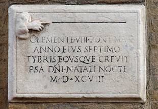 on the western side of the church of Santo Spirito in Sassia, this plaque remembers a flood on Christmas eve of 1598: « ...THE TIBER GREW UP TO HERE IN THE SAME NIGHT OF OUR LORD'S BIRTH » |
Literary sources contain records of floods in Rome as early as the 5th century BC. However, during the classical age and throughout the Middle Ages the city was not flooded more than once every 50-100 years. In the 1st century AD emperor Claudius had even opened a short artificial channel by the city of Portus (still extant, now known as Fiumicino channel), in order to improve the flow of the last stretch of the Tiber. |  plaque by the church of Sant'Eustachio: « IN YEAR 1495, THE TIBER ON A FINE DAY GREW UP TO THIS SIGN ON THE NONAE (5TH) OF DECEMBER ALEXANDER VI POPE - YEAR III » |
|---|
| Then, as of the late Middle Ages, some alterations partly affecting the course of the river caused floods to become more frequent, and the damages they caused turned out more and more serious. The earliest plaque known to have been hung dated back to February 2, 1230; it could be seen on the wall of Santa Maria in Traspontina church. But when the building was taken down and rebuilt nearby, in 1564, the plaque went lost. The oldest extant specimen dates back to November 6, 1277; it can be seen under a small arch at one end of Arco dei Banchi, a narrow passage on the river side opposite Sant'Angelo Castle, connecting via del Banco di Santo Spirito and the nearby corso Vittorio Emanuele. It once hung on the opposite side of the same lane, by the old church of Santi Celso e Giuliano, until the latter was rebuilt around 1730. Another plaque in memory of the same flood hung in the aforesaid church of Santa Maria in Traspontina, but this one too went lost. |
 a plaque dated October 8, 1530 by Santa Maria sopra Minerva's church: « UP TO HERE GREW THE TIBER AND ROME WOULD HAVE ALREADY BEEN COMPLETELY FLOODED, HAD THE VIRGIN NOT PERFORMED HERE HER SWIFT ACTION » |
|---|
 the oldest extant flood record (1277) « UP TO HERE GREW THE TIBER BUT, MUDDY, IT SOON RECEDED IN THE YEAR OF THE LORD 1277, IN THE 6TH INDICTION, ON THE 7TH DAY OF THE MONTH OF NOVEMBER, THE PAPAL SEE BEING VACANT » |
Resorting to old documents, etchings and other historical sources, it has been assessed that a total of 122 plaques were hung up to 1937, when Rome was flooded for the last time. Surprisingly, only few of them are no longer extant, or have been misplaced due to alterations. A large majority of these plaques date back to the 16th-19th centuries; the older ones often feature a hand, whose finger points towards the water level reached by the flood, together with the relevant year, and sometimes a short comment.
|
|---|

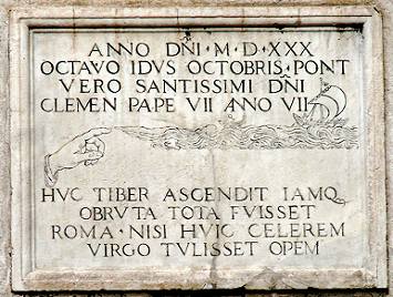
Flood plaques can be found anywhere in the old part of the city, but there were spots that had many of them: particularly the outer wall of Sant'Angelo Castle, the river wharf of Ripa Grande, and the church of Santa Maria Sopra Minerva; the latter is located next to the Pantheon, on one of the lowest spots in Rome, where the water reached a higher level (see further for details). The following excerpt, taken from two late 1400s chronicles, known as Memoirs of Paolo dello Mastro, and Diary of the City of Rome by Stefano Infessura, describe one of the most severe floods, whose plaque is shown above on the right:
[Memoriale di Paolo dello Mastro, II]
Dell'anno Domini 1422 die 30 novembre, in festo sancti Andreae, si fu una piena d'acqua sě grande a Roma, che allagň la maggior parte di Roma, et fece grandissimo danno, et tanto che non se poteria contare, et di questo ne fu cascione Braccio da Montone, perchč partendosi molto scorrucciato di Roma quando perdč lo Stato di Roma, ruppe le marmora dello laco di Pedeluco, et questo lo fece per dispetto delli Romani; et di questa pur ne resta la memoria in una preta nella faccia della ecclesia della Minerva.
[Stefano Infessura, Diario della Cittŕ di Roma]
In the year of the Lord 1422, on the 30th of November, St.Andrew's day, such a huge flood occurred in Rome that it inundated most of the city, and caused enormous damage, so much that it could not be estimated, and Braccio da Montone was responsible for this, because leaving Rome very angry when he lost the Roman State, he broke the marbles by Lake Piediluco, and he did this to the Romans out of spite; a memory of this flood is left in a plaque on the front of the Minerva church.
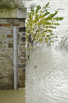
the flood of February 2, 1805, both featuring a tale-telling rowing boat The average level (depth) of the Tiber is about 6.5 metres; the present ground level, instead, is about 9 metres taller (i.e. the approximate hight of the protective walls between which the river flows as it crosses the city). Thanks to this protection, today a flood would only occur in the case the water level reached 15 metres. But in old times, when the walls had not been built yet, 12 metres were enough to cause a flood, usually starting from the Jewish Ghetto, and sometimes the water rose even higher. In order to keep a visual record of these event, hydrometers, i.e. graduated measures applied to a wall or to a building, came into use as of the early 1800s; however, traces of an ancient Roman one, found by Sisto Bridge, suggest that similar measures already existed in Rome's classic age. |
The aforesaid church (picture below) is the only place where a small number of plaques is still visible, while due to modern alterations, they are no longer found by the other two sites, although some of them are now kept in the Museum of Sant'Angelo Castle.
Santa Maria sopra Minerva's church: flood plaques  |


A very tall one, dated 1821, had been set by the old Ripetta river wharf; it consisted of several individual segments, strategically placed at different heights, so that according to the level reached by the water, the measure could be read standing on dry ground.
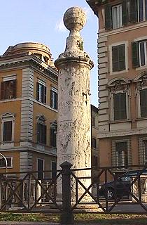
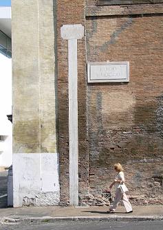 the hydrometer by San Rocco's church | When Ripetta wharf was demolished in the late 1800s, the only part of the hydrometer that was spared was the uppermost segment, which hung from an old house standing by the river bank. A few years later also this house was taken down, and the hydrometer was moved to the side of San Rocco's church, where it can be seen today. It is inscribed with the level reached by the water on the occasion of each flood (including the ones recorded in the previous centuries), the worst of which is dated 1598: over 4 metres or 12 feet above the present street level! Also the surviving column from Ripetta wharf is inscribed with dates of floods. column from the old Ripetta wharf → |
 |
|---|
When Cavour Bridge was built over the site of the old wharf (1896-1901) a new hydrometer replaced the preexisting one, along the flight of steps that leads to the river bank (see the illustrations).
|
 |
|---|

 |
 |
 |
|---|
But why were floods so frequent?
Besides the absence of walls by the banks, the other main reason was the irregular width of the river bed; in particular, along its course two bottlenecks had been created.
One was by Sant'Angelo Castle (left), in front of which pope Alexander VI had added a stout tower, built in the late 15th century, then removed in 1628; due to this alteration, a small embankment had been created on the western side of the river, and two arches of the bridge had been obstructed. Here the water also turned particularly turbulent due to the river's double bend, but Sant'Angelo Bridge, whose main structure is still basically the original one (2nd century AD), was perfectly built, and never collapsed.
 the Tiber by the castle (blue) in Antonio Tempesta's map, 1593 |
The other spot was by Villa Farnesina (right and below), the large mansion of the Farnese family located in Trastevere district, whose gardens, in time, had been enlarged, causing a considerable reduction of the river span.  view of the Tiber from Sixtus Bridge (E.Roesler Franz): the gardens of Villa Farnesina (left) clearly bulge towards the centre of the river, reducing its span |
 Villa Farnesina (green) in G.B. Nolli's map, 1748 |
|---|
| At the beginning of the rainy season, i.e. in October, the underground aquifers, partly dry after the summertime, were saturated again; only after this had happened, any further increase of the Tiber's flow due to rainfalls would mainly affect its level, giving reason for a higher frequency of floods from late November to mid winter, as testified by the dates on most plaques. When the water reached the streets, it followed the ground features, sloping towards the districts whose ground level was low. Furthermore, the water could also follow the Cloaca Maxima, the ancient Roman sewage whose net of tunnels still runs underground, usually flooding Pantheon Square, one of the lowest spots in Rome, and then spreading to the surrounding district. |  the outlet of the Cloaca Maxima by the Tiber bank |
|---|
 picture of a flood by the early 20th century |
Sometimes large parts of the city were reached by the flood, particularly the plains of the ancient Campus Martis area (i.e. once the western part of ancient Rome, now the historical centre), and the valleys between the city's many hills, as seen in the map below. There were districts, such as the Jewish ghetto, where the water could reach up to the houses' third floor. On top of this, during a flood the several small floating mills that once were moored along the river often broke loose, and drifted until they reached the closest bridge: here they obstructed its arches, either partly or completely, thus worsening the overflow and the pressure exerted by the water against the bridge itself. A sonnet in Jewish-Roman dialect by poet Crescenzo Del Monte tells about a flood in 1846, whose memory was still alive among the dwellers of the ghetto: |
|---|
L'ALLUVIONE lo figlio - che li morze - de Richetta, che c'era fiume 'ngkčtte: e lo viabbčnne me venne a fa' commare co' 'a barchetta. Fu l'anno de la mola: e me convenne, p' i' a la milŕ, passŕ' da gnora Betta e pe' un ponte sboccŕ' 'n casa Cočnne, ch'abbitaven' allora a la Piazzetta. ...La mola? Fu una notte de teróre! La fiumana 'a strappň in men d'un minuto e bůuum...! ě a sbŕtte a ponte! ŕah! chi gelore! E tre ňmmeni che c'ereno serati chi terore a sentilli: aiůuto...! aiůuto...! fintanto che non fureno salvati. |
THE FLOOD the son - who later died - of Henriette, when the ghetto was under a flood: and the baby's father 1 came to ask me as a godmother 1 in a boat. It was the year of the mill: and to go to the circumcision, I found convenient to go through Mrs. Elizabeth's house and over a bridge 2 reach the house of the Cohens, who then lived in the small Square. 3 ...The mill? That was a night of terror! The river flow tore it loose in a minute and bang...! It crashed against the bridge! 4 Ah! What a fright! And three men who were locked inside, 5 How terrible it was to hear them cry: heeelp...! heeelp...! until they were rescued. Crescenzo Del Monte, December 18, 1915 | |
|
1. - The newborn's father was going to ask who tells the story to be the godmother in the circumcision ceremony. 2. - An occasional bridge made of wooden planks, spanning from one house to the other. 3. - Piazza delle Tre Cannelle (see also page 7). 4. - Cestius Bridge, linking the Tiber Island to the right bank of the Tiber (opposite the ghetto). 5. - Some mill workers also slept in the floating mills. |

Today the risk of a flood is very unlikely, thanks to the walls, about 12 m or 39 ft tall, that protect the city on both sides of the Tiber. After the last serious overflow, in 1870 (many relevant plaques exist), the decision of building them was taken, and their making started in 1875. Since then, Rome was flooded again only three times, the last one in 1937 (picture on the right). |
 photograph taken in 1937, in via Portuense, during the flood on December 17th, whose commemorative plaque by the church of St.Bartholomew on the Tiber Island is shown on the left |
|---|
 | the course of the Tiber and the city's land features: HILLS 1 · Capitolium 2 · Palatine 3 · Quirinal 4 · Viminal 5a 5b 5c · Esquiline 6 · Coelian 7a 7b · Aventine 8 · Janiculum 9 · Vatican AREAS AND BUILDINGS A · Colosseum B · Roman Forum C · Campus Martis D · Pantheon E · Tomb of Octavianus Augustus F · Sant'Angelo Castle G · St.Peter's and the Vatican |
|---|
However, the price payed for this operation was high: several centuries-old buildings that stood along the river banks had to be taken down, as well as the two river wharfs, Ripa Grande and Ripetta. And together with the buildings, also many typical views went forever lost, as can be seen in the pictures on the right.
Even some ancient bridges, among which Sant'Angelo and Cestius (see also The Tiber Island in this section), had to be altered in order to fit the new width of the river bed, causing the loss of their original shapes and sizes.") the making of the walls in progress, in a picture of c.1890: on the left,
the making of the walls in progress, in a picture of c.1890: on the left,it clearly shows the cut through the old buildings that stood along the river |
 (↑) a view of Ripetta wharf in the late 1800s, in a painting by E.Roesler Franz, and the same spot today (↓) 
|
|---|
Nevertheless, the danger has been minimized, but it has not completely overcome; particularly rainy seasons, possibly combined with accidents similar to the ones previously described, which may involve large boats moored by the Tiber banks (as in the picture on the left), might still cause damages to bridges, and make the water level reach the top of the walls. |
 boats stuck under the arches of Sant'Angelo Bridge, during the high water in December 2008 |
|---|
