 |
 ~ Curious And Unusual ~ - 6 - The Tiber Island |
  |
|---|
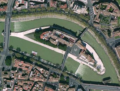
As the Tiber crosses Rome's historical centre, it draws a double bend; almost at its end is a small island, named after the river, whose length is about 300 m (330 yards), and about 80 m (100 yards) in width. It has the typical shape of a vessel; this inspired a legend, according to which the island is located on the site of a sunken ship.
 view of the Tiber Island from its western end, with Cestius Bridge on the right |
A more popular version, known since the early times, says that when the last king of Rome, Lucius Tarquinius Superbus, was upthrown in 509 BC, the people tried to destroy his enormous stash of crops by throwing them into the Tiber. But the amount was so great that it formed a small island. Then, some time later, during a plague, a ship was sent to Epidaurus, in Greece, to visit the temple of Aesculapius, the god of medicine. One of the snakes sacred to the god was taken back to Rome, and when the ship reached this spot, the snake jumped onto the island, which was ever since dedicated to this divinity and to medical practice. |
|---|
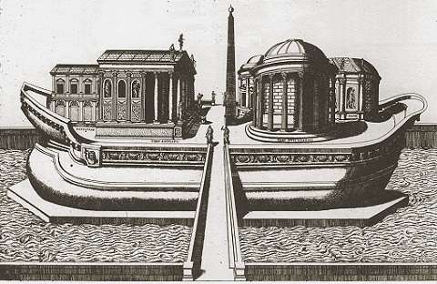
For this reason, a temple sacred to Aesculapius was built there, and the island itself was arranged as a ship. Its sides were entirely lined with travertine marble, so to resemble the prow and stern of a vessel, featuring reliefs related to the god. An obelisk was stood in the centre, facing the temple, representing the ship's mast. It is still uncertain when these changes took place; the suggested dates are the 3rd century BC or, more likely, the 1st century BC, as also the two bridges are of the same age.
 |
 |
|---|
Unfortunally, we only have a vague idea of what the island might have really looked like in the days of old.
 the few remains of the original facing |
 the snake jumping from the ship onto the island (top right), by the reclining allegory of the river Tiber, in a 2nd century medal |
A revived interest for ancient Rome led several 16th century artists to try and render the early look of the island, often with an exceeding touch of imagination, such as the etching by Ambrogio Brambilla (1582) shown above. However, similar depictions were based on the presence of a larger number of remains of the original buildings than the ones extant today, so they can still be considered consistent with the island's ancient shape. |
|---|
| Today only small traces of the original facing are still visible by the eastern end of the island, while nothing is left of the temple; two surviving fragments of the obelisk are kept in the National Museum in Naples, and one in Munich. The island is connected to the mainland by means of two ancient bridges of Roman age. In fact, it was originally called insula inter duos pontes ("the island between the two bridges"). On the western side, Cestius Bridge (picture on the right) joins the island to Trastevere district. It was built in 46 BC, and named after Lucius Cestius, a city administrator; his brother Gaius Cestius is better known, for having been buried in the famous pyramid by St.Paul's Gate. |
 Cestius Bridge |
|---|
Midway along the bridge, on its northern side, two ancient inscriptions remember restoration works. The larger and older one, rather faint, mentions the works commissioned in 370 by two emperors, brothers Valens and Valentinian I and by the latter's son Gratian; actually, the bridge was officially named after Gratian, and only in the late 1800s it took its present name, when it was rebuilt (see further).
The smaller plaque, much simpler and rougher, dates back to the late 12th century and mentions a restoration by Benedetto Carushomo (or Carissimi), one of Rome's senators, i.e. city administrators, whose mandate was from 1191 to 1193.
 the plaque that remembers the senator: � BENEDETTO, HIGH SENATOR OF THE NOBLE CITY OF ROME, RESTORED THIS BRIDGE, ALMOST DESTROYED � |
After having been damaged by floods several other times, in 1849 the bridge was deliberately broken by general Garibaldi's men, for defensive purposes, during the siege of Rome set by the French troops. the shape of Cestius Bridge: how it used to be (↑ above) and how it is today (↓ below)  |
|---|
It was completely rebuilt between 1888 and 1892, using the original fragments, but the shape of the bridge was altered, in order to fit the new protective walls along the sides of the river (see also page 3 in this section): its two sloping ends were partly straightened, and the two arches on which they rested were enlarged, so to match the size of the central one. This alteration had also the purpose of letting the water flow more easily than before, thus reducing the risk of further floods. On this occasion, Gratian Bridge was renamed Cestius Bridge.
However, in time it also took some other popular names, such as St.Bartholomew Bridge, after the main church that stands on the island, and Iron Bridge, after the chains with which small mills were moored here (see also There Once Was in Rome... section).
| On the eastern side of the island, Fabricius Bridge leads towards the mainland of Ripa, the same district whom the island belongs to. It was built in 62 BC, thus slightly earlier than Cestius Bridge, what makes it the oldest among the historical bridges extant within the urban boundaries, and second among all only to Milvius Bridge, which was once located outside the city, 2.5 km or 1.5 mi off the northernmost gate of the city walls. Lucius Fabricius was a city officer in charge for the streets (curator viarum); his name is carved in large letters on the white frame of the bridge's arches. Names of two consuls in smaller letters (Marcus Lollius and Quintus Lepidus) were added on the occasion of the bridge's first restoration works, in 21 BC. After the establishment of the Jewish Ghetto (1555), whwhose area started on the very spot where the bridge reaches the mainland, it was also called Bridge of the Jews. |
 Fabricius Bridge |
|---|
But the locals call this bridge more often Ponte Quattro Capi ("Four Heads Bridge"), as on each side a four-headed figure rests on the baluster. These are ancient Roman carvings, but they do not belong to the original structure; they were set here in the late 1500s, by pope Sixtus V, on the occasion of restoration works.
 |
According to a popular legend, the heads are those of the four architects whom the pope had entrusted with the restoration of the bridge.
|
|---|

The branch of the river that runs below Fabricius Bridge is rather shallow; when the making of the protective walls and other works were discussed by Rome's administrators (1871-75), somebody even suggested to fill the river bed on this side, letting the Tiber free to flow only below Cestius Bridge: this would have caused the island to disappear, as it would have been joined to the river's eastern bank. Luckily, this project was disregarded.
The island's ancient medical tradition, related to the cult of Aesculapius, never died out in time. In the early Middle Ages, when the temple had already collapsed, the Tiber Island became the site of a hospice, run by monks, where the sick people could be treated. This popular institution slowly grew into a real medical establishment, the Fatebenefratelli Hospital, founded in 1584, still active today.
| Instead, the other half of the island is mainly occupied by a small square, closed at one end by a church dedicated to St.Bartholomew. In maps of Rome of the 18th and 19th centuries the Tiber Island was actually labelled as St.Bartholomew's Island. The church was founded over the ruins of the ancient Temple of Aesculapius around year 1000, by the German emperor Otto III, to hold the remains of St.Adalbert from Prague. Around 1200 also St.Bartholomew was buried there, and the title of the church changed into that of the latter martyr. Although it was rebuilt in 1624 after having been seriously damaged by a flood in the mid 1500s, it maintains its original Romanesque belltower. Under its porch, a small plaque indicates the water level of the very last flood remembered in Rome, dated December 17, 1937 (some features in this church are also mentioned in the Fountains monograph and in There Once Was In Rome... section).. |  St.Bartholomew's church, with the pillar in the foreground |
|---|
In the centre of the square stands a four-sided pillar with the statues of St.Bartholomew, St.Francis of Assisi, St.Paulinus of Nola (patron of the river mills, and popularly credited for having invented the church bell), and St.John of God (a Spanish saint, founder of the Brothers Hospitallers Order, also known as the Fatebenefratelli i.e. Do-good Brothers). The pillar also commemorates the opening of the First Vatican Council (1868).
Sometime during the early Middle Ages the obelisk, which had already collapsed, was replaced with a column topped by a Christian cross, symbolically representing the triumph of Christianity upon the ancient pagan civilization. The column faced St.Bartholomew's church in the same way as the obelisk once used to face the temple; up to the mid 19th century, on August 24, a list of names of those who had not complied with the Easter Precept (i.e. a yearly compulsory confession and Holy Communion, taken at Easter time) was hung to the column, to be frowned upon by everybody.
Then, in 1867, a carriage crashed into it, damaging it in such degree that Pius IX preferred to have it removed and replaced with the aforesaid pillar.
Opposite the tower stands the church of St.John Calybite, of very ancient origin, although the present building dates back to the 17th-18th centuries. An image of the 1200s, known as the Madonna of the Lantern, that once hung by the riverside, is kept inside the church; it is credited with a prodigy said to have taken place in 1557 when, during one of the frequent floods, the flame of a lantern by the image kept burning, despite being submerged by the water. A copy of this image can be seen at the base of the belltower. |
 (↑ above) the House of the Caetani and (← left) the small head known as 'the Maid' |
|---|

A flight of steps leads down to the river level, where in the early 1900s the wide bank was built, acting as a walkable platform that runs all around the island. Here the locals and tourists alike like to stroll, to sunbathe and, especially during the summer, to attend cultural events such as film festivals, concerts, etc. The bank also makes an excellent viewpoint for taking a close look at the old bridges from below.
Just further south along the river's course, following the island, is another interesting feature: the so-called Ponte Rotto (Broken Bridge), whose story is described in depth in There Once Was In Rome... section.

a view of the island from its south-eastern end; on the left, after Cestius Bridge,
an underwater barrier built in 1994 to reduce the water current spans the river bed
