


The starting point of the tour is piazzale Flaminio, very easy to reach from any part of the city: there is Flaminio subway station (line A), several bus stops, the terminus of tramway line no.2 and even the train station of the Roma Nord railway (Roma-Civitacastellana-Viterbo).
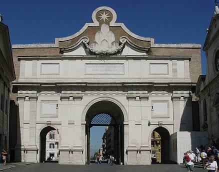
On the southern side of the square stands the mighty Porta del Popolo [map ref. 1], the northernmost gate of Aurelian's walls, crossed by the ancient via Flaminia: this road, built in the 3rd century BC by consul Caius Flaminius, ran straight from the Capitolium hill, reaching the northern inland territories as far as Ariminum (now Rimini), on the Adriatic coast, over 300 km / 220 miles from Rome. Furthermore, another important northbound road, via Cassia, springs from via Flaminia a few kilometres off this spot: therefore, any traveller that once approached Rome from anywhere in the north, would have entered the city through this gate.
 |
 |
|---|
with a single archway and two stout towers, in an etching by Giuseppe Vasi of the mid 18th century
The aforementioned roads are presently still in use, and both of them have maintained their original names. Instead the gate, initially known as Porta Flaminia, during the Middle Ages was renamed Porta del Popolo and the origin of this name is still under debate.
According to one theory, poplar trees (in Latin populi) may have once grown over this site; the other theory is that the gate was named after the church that stands by its inner side. In 1099, pope Paschal II had a small chapel built on this spot, with the purpose of driving away the ghost of emperor Nero who, according to a legend, haunted the surroundings of this place (see also Legendary Rome, page 8). Its title was Santa Maria del Popolo (i.e. St. Mary of the People), as the expenses for the making of the chapel were paid by the city administrators or, in other words, with the money of the people of Rome. The chapel was enlarged into a church in the 1200s, and then rebuilt into its present shape in the second half of the 1400s. More details can be found in The Rioni section.
| During the Middle Ages, a further name this gate was given was St.Valentine's Gate, because about 1 km or half mile further north, the Flaminian Way runs by the catacombs where the famous saint was buried. Up to the mid 1500s, the shape of Porta del Popolo was still the same as it was in Roman times, a simple archway built with bricks, lower than the present one, flanked by two large semicircular towers; its outer side was covered with a thick white stone facing, an alteration that emperor Honorius had carried out to all the main city gates around year 400. The ground level, though, in time had considerably risen, so that in the 16th century the gate appeared partly buried. St.Peter and St.Paul, by Francesco Mochi (c.1630) → |
|
|---|


Between 1562 and 1565, pope Pius IV had it completely rebuilt in a Renaissance fashion.
 the inner side of Porta del Popolo |
Michelangelo had been initially given the commission for its making, but since he was busy at the time, the work was handed over to another distinguished architect, Nanni di Baccio Bigio.
|
|---|

Nanni di Baccio Bigio designed the new Porta del Popolo as a tall central archway, encased between two stout towers with a square section (see the etching above). The four central columns on its outer side come from the ancient St.Peter's, which in those years was being taken down and completely rebuilt into the present basilica.
|
the inner side of Porta del Popolo in 1655: some traces of →
the Roman towers can be seen on both sides of the archway, and the upper part, which Bernini was still working upon, is unfinished The coat of arms of Pius IV hangs from the attic, with a plaque that mentions how the pope had the gate enlarged, and a stretch of Flaminian Way paved. The crenellation that runs above the upper part of the gate has a rather fancy shape, resembling small stylized busts of soldiers in armour. Around 1630, the statues of St.Peter and St.Paul, the saint patrons of the city of Rome, were added to the gate. They had been carved by Francesco Mochi, a distinguished sculptor of the Baroque age, for the basilica of St.Paul Outside the Walls; but for some reason they were refused, so they were set here. |
 |
|---|
|
When in 1655 the Swedish queen Christina came to Rome, invited by pope Alexander VII, Gianlorenzo Bernini was asked to carve a large heraldic device of the Chigi family (whom the pope belonged to) and hang it on the inner side of the attic, together with an inscription in Latin that reads: � may your entrance be prosperous and happy � |
|---|


In 1879, in order to deal with the increased traffic that crossed the gate, architect Virginio Vespignani took down the square towers replacing tham with two archways, smaller than the central one; on the same occasion four more columns were added to the gate, similar in shape to the ancient original ones.
| During these works, some remains of the original Roman structure were also found, which gave the evidence that this once really was Porta Flaminia, and allowed to detect the height of the ancient ground level, rather lower than the present one. Stepping back into piazzale Flaminio, looking towards the gate, on the right the wall soon comes to an end, while on the opposite side it follows the Pincio Hill. This stretch of wall, as well as the road winding around its base, has been called Muro Torto ("crooked wall") because by the first bend a short part collapsed, not long after having been built. Historian Procopius of Caesarea wrote that the Romans called it Murus Ruptus, i.e. "broken wall" (Gothic War I, XXIII). |
 the Muro Torto |
|---|
Before the making of the set of walls by Aurelian, this strech, as well as the following one, was the retaining wall of a large villa (Horti Aciliorum) that stretched over the top of the Pincian Hill, including the grounds at the back of the present Villa Medici and Trinit� dei Monti. It included also a bathing pool and a nymphaeum. It was built in the 2nd century AD, and originally belonged to the Anicii family, but two centuries later it was owned by the Pincii, after whose surname the hill took its present name (see Curious and Unusual). The western and northern sides of the villa's retaining structure were included in Aurelian's set of walls.
 the boundary of the Pincio gardens, once Horti Aciliorum: the stout tower in the center is not an ancient placement, but a public lift built in c.1900, now no longer working |
The grounds by the wall, located immediately outside the ancient urban boundary, were once used as a graveyard for anybody whose remains were not welcome by the city churches, such as non-Christians, prostitutes and convicts who refused to repent before being executed. Such custom made this spot become rather ill-famed; together with the aforesaid legend about the ghost of Nero, this gives reason for another name the collapsed wall was known by during the Middle Ages: Muro Malo, i.e. "evil wall". It is advisable to walk along the grass on the right of the narrow path, close to the road, where you can keep sight of the wall. Its height soon reaches a height of about 20 metres, as it surrounds the eastern side of the steep Pincio Hill, then its northern side. |
|---|
In ancient times, important families owned mansions and gardens in this area: one of the largest belonged to the Pincii family, whence the name given to the site through the centuries.
| After a rather sharp bend, also the villa's grounds grow steep; here the difference in level with via del Muro Torto is considerable. We are now climbing towards the overpass that links Villa Borghese to the Pincian Gardens. Up to the early 1900s there was no connection between the villa (still a private property) and the top of the Pincio Hill, which could be reached only from the opposite side. After becoming a public park - the king of Italy bought it from the Borghese family in 1901 - within a few years the overpass was built, a comfortable and charming approach to the gardens that crosses via del Muro Torto from above. A quick diversion along these shady paths, decorated with over two hundred marble busts of outstanding Italian artists and scientists (more details in Curious and Unusual, page 14) won't take away much time. Cross the bridge, and follow the first path on the right: you will soon come to a rather unusual water-clock [map ref. a], built in 1807: its outer structure is mostly made of wood, while inside it has a complicated and delicate mechanism propelled by water. Its author was a Dominican priest called Giovanbattista Imbriaco; his surname, which sounds as "drunken" in Roman dialect, is a common pun for locals. |
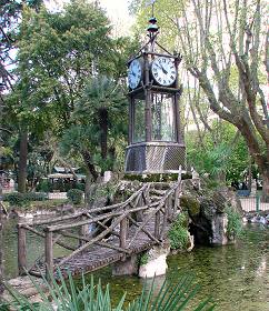 the water-clock |
|---|
On the left, another path leads towards one of Rome's most charming sites, piazzale Napoleone
[map ref. b], with a great view over the city. Here a long balcony overlooks piazza del Popolo; just beyond the tall Egyptian obelisk, a perfectly straight road crosses the river Tiber and runs for almost 2 km (over 1 mile) down to the Vatican, where St.Peter's dome overlooks every other building in town.
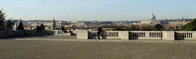
the balcony in piazzale Napoleone
On the left, the skyline is crammed with other domes belonging to the many ancient churches of the historical centre. On the right, in the distance, the tall aerial of the national TV broadcasting company marks the top of Rome's tallest hill, Monte Mario.
Walking back to the bridge, you may wish to visit also the Pincio gardens (see the relevant page in Curious and Unusual), where a roman obelisk stands [map ref. c] (more details in the Obelisks monograph).
 |
 |
 |
|---|