


| The last and longest part of Aurelian's walls tour starts from piazzale Appio. Here, just a few metres on the left of Porta San Giovanni mentioned at the end of part II, stands the much older
Porta Asinaria [map ref. 1].
The gate itself is not very large, but the tall and mighty towers flanking it make the complex rather huge. Their base has the shape of a half oval, protruding considerably from the wall, so to allow an easy defense of the gate: from the many round-shaped windows weapons could be used against the enemy. The origin of the gate's name is still debated, since it is believed that an ancient minor road ran by this site, along which donkeys (in Latin asini) were driven into town. The more important via Tusculana, reaching Tusculum (see map of ROME'S ANCIENT SURROUNDINGS), probably sprung from this road not far from the gate. Today via Tuscolana (modern spelling) starts some 500 metres / 550 yards further south, as shown by the map below, an important suburban connection reaching the many small villages located south-east of the city, still basically following the same direction it had in Roman times. |
 Porta Asinaria |
|---|
 now via Tuscolana (in yellow) starts about 500 metres south of Porta Asinaria |
Porta Asinaria was abandoned in the 16th century, when the nearby Porta San Giovanni was built; by that time, the Roman gate had also been partially buried, due to the modern street level which had considerably risen, and only in recent times it was freed again from earth and debris. In fact, you will notice how the base of each gate stands at a different height, despite the very short distance between them. Today, the area immediately surrounding the gate is closed to the public. Following via Sannio, where a small crafts and clothes market is held daily (except on Sundays), you will soon reach the entrance of the public garden on the left, where you can walk back towards Porta Asinaria and take a better view over the gate than from the road. Back on via Sannio, a few blocks of buildings will soon cover the sight of the wall, which runs at the back, surrounding the Lateran's grounds. So where the road comes to an end, by a small square, look for via Farsalo on the right, and follow it towards piazzale Ipponio. Here the wall is in rather bad condition, but visible traces are still standing on the left, protected by an iron railing. |
|---|
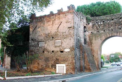
| Crossing the large square, move to the inner side of the wall, along via della Ferratella. As you walk down this road, close to the remains, note again the considerable difference between the old street level and the present one, which practically reaches the height of the wall's arches. As via della Ferratella gradually slopes towards the next gate, the wall becomes slightly higher; by largo dell'Amba Aradan you will see another sentry passage (not open to the public), similar to the one found by Porta Pinciana, described in part I, page 2. Finally, by a large square, a stout tower projects towards the inner side of the wall, flanked by a number of archways opened in modern times, for traffic reasons. At the base of the tower is a tiny archway, slightly taller than 1 metre (or 3 ft) from the present ground level, completely walled up: this is - or, better, was - Porta Metronia [map ref. 2]. |
 the inner side of Porta Metronia |
|---|
 the channel (highlighted in blue) in a map of c.1590 |
The gate has been closed since 1122, when pope Callist II had it walled up, using it as a passage for a water channel that flowed along the outer side of the wall. The channel, called Marana (and later in time Acqua Mariana), was forced to flow through Porta Metronia, from where it reached the central districts. Several maps of Rome of the 1500s feature the channel crossing Porta Metronia (see detail on the left). In time it dried, until it completely disappeared; but still in the early 20th century traces of this channel could be found by this spot. Above the gate hang two plaques; the one on the left is medieval (dated 1157), and reads as follows: |
|---|
The plaque was set 35 years after the gate was closed. The few letters in the header (R |
 |
|---|
This is also one of the earliest known medieval inscription that bears the abbreviation 'SPQR' (which stands for "the Senate and the People of Rome"). But the most interesting aspect of this plaque is that it mentions the ten Consiliatores: they were a body of ten civic administrators (although their number was subject to changes), chosen among the senators, which had been first created in 1143 as an attempt by the people of Rome to shake off the temporal power exerted by the Church. The Consiliatores retrieved the use of the acronym 'SPQR', which had been abandoned since the fall of the Roman empire. This institution lasted for about one century, during which Rome's senators openly challenged the pope's authority on several issues concerning the administration of the city.
On the right hangs a second plaque, dated 1579, referring to a further restoration of the wall, sponsored by pope Gregory XIII.
 detail of the outside of Porta Metronia, walled up in 1122; note the opus listatum texture on both sides of the archway |
 the outer side of the wall by Porta Metronia; the several archways are modern (early 20th century) |
|---|
By moving to the outside of the wall you can take a better view of the closed gate, on whose sides the Roman building technique known as opus listatum (or vittatum), consisting of rows of bricks and stones laid in alternate order, can be clearly seen. You may also wish to step a little further, to the opposite side of the square, to take an overall view of this L-shaped corner of the wall, once unbroken; the several archways were in fact opened in the early 20th century, to let vehicles cross the ancient boundary.
The tour carries on following the outer side of the wall, along viale Metronio, which after a while changes name into viale delle Mura Latine.
| Along this stretch, about 850 metres or ½ mile in length, the wall separates the modern Appio-Latino neighborhood, on the left, built in the late 19th-early 20th centuries, from the area on the inner side, where ancient churches and archaeological remains can be found. Just before reaching the following gate, the road makes a bend to the right: from this spot, looking back towards Porta Metronia, the sequence of stout towers provides one more charming view.
|
 |


)