


From the end of the Passetto, opposite St.Peter's Square, springs via di Porta Angelica, so called because up to the late 1800s it led towards Porta Angelica, one of the two gates belonging to the wall of Pius IV, described in part I. On the left side of the street a modern wall now marks the official boundary between Italy and the Vatican grounds; it was built shortly after 1929, when the Vatican became independent.
The gate you soon pass by, constantly looked over by Swiss Guards, is Porta Sant'Anna, [map ref. b], flanked by the small church of Sant'Anna dei Palafrenieri; this is the only access to the small state for non-Vatican citizens (a permit or visa is required).
As you stand in front of Porta Sant'Anna, in the background you can see one of the stout round towers that around 1450 pope Nicholas V added to the old set of walls built under Leo IV [map ref. c]; this tower, which in the map below is featured in the top right corner, is now largely hidden by the barracks of the Swiss Guards, although its side is still clearly visible.
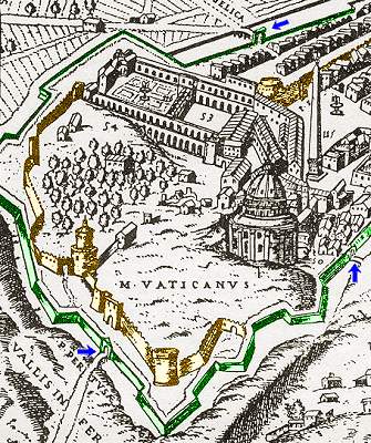 |
← aerial view of the Vatican, in a map of 1590: the old boundary surrounding the Vatican Hill, built under Leo IV in the 9th century (including the end of the Passetto, top right) is featured in yellow, with round towers added under Nicholas V in the mid 1400s; the set of walls built under Pius IV in the mid 1500s is highlighted in green and arrows indicate the gates (from above, anticlockwise: Porta Angelica, Porta Pertusa, Porta Fabrica) Slightly further, stands an old brick house with barred windows: by the time the modern wall was built, its door was sealed, and so were the upper windows, whose central one bears a fresco dated 1614, featuring St. Anne, the Virgin Mary, and the infant Christ (right); an inscription claims that it belonged to a religious brotherhood called the Confraternity of the Horse Groomers (see also Curious and Unusual, page 15 about this topic). |
 the 1614 fresco featuring St.Anne, the Virgin Mary, and the infant Christ and the inscription claming the property |
|---|
At the end of via di Porta Angelica the tall palm trees of piazza del Risorgimento come into sight. Here [map ref. d] the modern wall joins at right angles the surviviing stretch of wall built by Pius IV in the 1560s. A large coat of arms of Pius XI (1922-39) hangs from the corner: he was the pope under whose pontificate the Vatican gained its independence.
On this very spot once stood Porta Angelica, through which the pilgrims coming to Rome from the north along the Cassian Way entered the city. The gate was taken down in 1888, together with a long stretch of wall that reached Sant'Angelo Castle (see part I). The outer side of the wall was protected by a trench, so that a small bridge had to be crossed to enter the gate.
 the scanty relics of Porta Angelica: compare this picture with the one on the right, that features these fragments still in place |
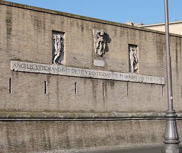
On the opposite side of the street [map ref. e], a small fragment of the wall's base, below the street level, is now covered by a glass panel. Instead, a few remains of the original Porta Angelica were hung on the part of the wall that was spared, just past the corner: they consist of a pair of angels, the coat of arms of Pius IV that hung above the gate's archway and a Latin inscription (Psalm 90:11) that reads: "HE HATH GIVEN HIS ANGELS CHARGE OVER THEE TO KEEP THEE IN ALL THY WAYS". |  the original Porta Angelica, in an 18th century etching: note the bridge over the trench |
|---|
A further inscription, "WHOEVER WANTS THE REPUBLIC TO BE SAFE, FOLLOW US", that was also found on the twin Porta Castello (see part I page 1), went lost.
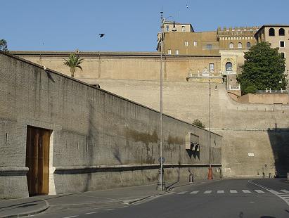 the wall of Pius VI (left) joins at right angles the much taller wall of Paul III (right); the modern Porta di Santa Rosa, opened in 2006, can be seen in the bottom left corner |
On leaving the square, the street, now called via dei Bastioni di Michelangelo, makes a bend at right angles (picture on the left). |
|---|

| The Renaissance building high above the wall, whose top is framed with crenellation, is called the Palazzetto of Innocent VIII or Palazzetto Belvedere, a summerhouse built in c.1485 on a peak of the hill from where the pope could enjoy a striking view over the whole city; the first nucleus of the Vatican collection was housed there, and today it is itself included in the Vatican Museums. By the first crossing, the wall makes again a turn at right angles, this time to the left, forming a strong and sharp bastion [map ref. f], whose project was drawn by Michelangelo (whence the name of the street). A large coat of arms of Paul III, bearing the six fleur-de-lys of the Farnese family, whom he belonged to, hangs high above the corner. The wall now follows viale Vaticano, a long road that gradually climbs towards the western side of the Vatican Hill. Very soon, on the left, you'll pass by the large doorway of the Vatican Museums (this used to be the entrance, now only used as an exit), whose top is decorated with the coat of arms of Pius XI, flanked by two statues featuring Michelangelo and Raphael (1932). |
 the bastion drawn by Michelangelo; note the coat of arms of pope Paul III and, high above, the Palazzetto Belvedere |
|---|
The road grows gradually steeper, and as soon as it comes to a left turn, the surrounding environment somewhat changes: viale Vaticano becomes narrower, as it starts winding around the boundary wall, all the way to the top of the hill.
 the statues above the Vatican Museums' entrance |
 a shady view along the western side of the walls |
This rather long stretch of wall has four bastions, i.e. four large arrow-shaped placements with a strengthened structure (see picture below); any part of the walls between two of them would have been within the range of the artillery; in particular, cannons were fired from large windows opened in the corners of each bastion. |
|---|
The side of the road opposite the walls, where a steep and bare slope once protected the Vatican citadel, is now covered with the buildings of a modern neighborhood.
 one of the bastions; note the two windows in the corner from where cannons were fired, and a small service passage below (both of them now walled up) |
Due to the road's several sharp turns, it is safer to walk on the side of the road opposite the wall, always being aware of the fast traffic. It might seem strange that on this side of the hill the boundary had no gates at all; but up to the 1800s beyond the Vatican there was nothing but wilderness, and no road crossed this area, either: a gate here would have made no sense, and it may have even weakened the defensive structure. Only a few service passages were opened here: they were very small, such as the one shown below on the left, often located by a bastion or on spots easy to defend: their purpose was to enable the masons to check the wall from time to time, and to restore it, when needed. |
|---|
 a typical service passage, with small heraldic insignia carved on the keystone |
When the Vatican became an independent state and the walls turned into an official boundary between two countries, all these passages were walled up; they can still be told by the white lintel that framed them. Most of them bear small heraldic insignia on the keystone, referring to the ruling pope of the time. | 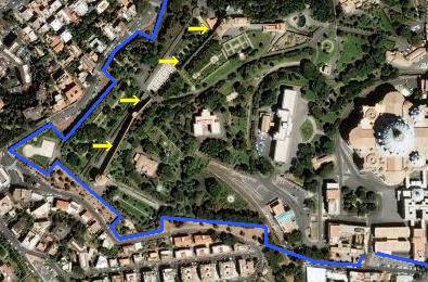 the outer wall is shown in blue, the remains of the early wall by Leo IV (yellow arrows) are still visible from above |
|---|
Also along the wall hang a number of coats of arms belonging to different popes: any time the wall was lengthened, restored, refurbished or simply surveyed, the pope who sponsored the works left his mark. One of the most common ones to be seen feature three bees (below left), which represent the heraldic device of the Barberini family, referring to pope Urban VIII (1623-44).
 the coat of arms of Urban VIII |
On the inner side of this stretch, completely unseen from the road, stand the remains of the early defensive wall built by Leo IV in the 9th century (see picture above right and the map at the beginning of the page). At the top of the hill, we finally reach the westernmost bastion, so sharp that the road almost makes a U-turn: from this corner it is possible to take a view of both the western and southern sides of the wall.
|
 the sharp bastion at the western end |
|---|


