


| This part of the tour starts from Sant'Angelo Castle, which can be reached on foot from the central districts by crossing the beautiful Sant'Angelo Bridge. It can also be reached by bus: several lines (30, 70, 81, 87, 280, 492, 913, 926, 990, and others) stop in piazza Cavour, the large square at the back of the castle; subway line A (Lepanto station), instead, is located about 800 metres - ½ mile off the castle. As you walk round Sant'Angelo Castle in clockwise direction, along the outer side of the moat, you will notice a tall wall with several archways, linking to the castle [map ref. 1]: this is the Passetto ("small passage"), which used to be called alternatively corridore di Borgo ("Borgo's corridor"). |
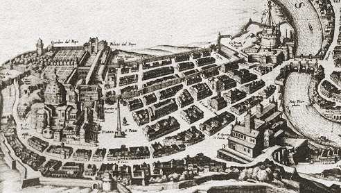 detail of Borgo district, from Sant'Angelo Castle (upper left corner) to the Vatican (right), as featured in a map of Rome dated 1606 |
|---|
From a historical point of view, this wall is dealt with by page 5 in the Curious and Unusual section, therefore only the essential notes will be repeated in this page, with some more reference illustrations, and facts about Borgo district.
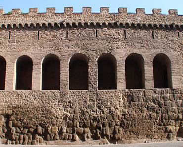 the Passetto: the conceiled passage runs behind the narrow windows in the upper part of the wall |
The Passetto is considered the oldest surviving part of the walls that enclose the whole Vatican area, having been built at the behest of pope Leo IV (c.850) in place of an earlier and shorter wall that the Ostrogothic king Totila had erected around 550; such rather primitive structure had alredy crumbled and been rebuilt a number of times. The Passetto represented its first part, i.e. the stretch that closed the otherwise unprotected grounds between the fortress, located by the river, and the ancient St.Peter's basilica, at the base of the Vatican Hill. The large church had been built between AD 320 and 330, on the site where apostle Peter (i.e. the first pope) had been martyrized and buried. Since the early centuries, the basilica had become a place of worship, visited by crowds of pilgrims coming from faraway lands. |
|---|
It should be kept in mind that, by the time of Leo IV, the popes did not dwell in the Vatican area, as their residence used to be located in the southernmost part of Rome, in the Lateran grounds, by a large complex known as the Patriarchium, which included among other buildings the basilica of St.John, well protected by the nearby ancient Roman wall.
| Instead, St.Peter's tomb and the Vatican basilica stood in a suburb, outside the city walls, which stretched along the opposite side of the river Tiber. It was no sooner than the late 14th century that, on the occasion of the papal seat being brought back to Rome, after having been moved to Avignon (France) for almost seventy years, and meanwhile having the Patriarchium been burnt to the ground by a fire, the popes chose to reside officially near the basilica. | 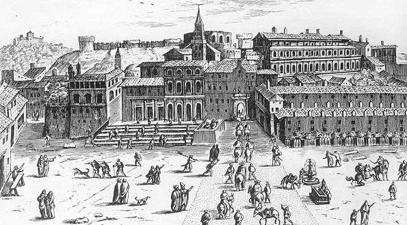 St.Peter's in the first half of the 1500s: the basilica was still the ancient one, built under emperor Constantine I; some parts of the wall sponsored by Leo IV can be seen in the distance, on the top of the Vatican Hill |
|---|
Therefore, the purpose which Leo IV had the wall built for was only to protect the holy shrine, not the papal seat. Furthermore, before the making of the wall, the Vatican area was rather poorly inhabited: only pilgrims coming to Rome to worship St.Peter's tomb and foreign merchants camped here. The only defense from raiders and pillagers, who from time to time came either by land and by sea, was the natural barrier provided by the Vatican Hill, at the back of the basilica, and by the Janiculum Hill, further south. But then, once the open area turned into a fortified citadel, hospices, inns, hostels and other establishments where pilgrims could be accomodated started to appear. This gave origin to several foreign communities. The largest community was that of the Saxons, who in their own language used to call this area Burg (i.e. "citadel, borough").
The small enclave, which became known as Leo's City, remained separated from Rome for eight more centuries. Actually, only in 1585 the citadel was officially included among the city's historical districts, thus becoming the 14th, called Borgo, a corruption of its foreign name.
Before leaving the castle to start the tour of the walls, follow its gardens for a few more metres, up to the point of the western bastion [map ref. a].
 in Nolli's map of 1748, Borgo Vecchio (highlighted in green) is divided from Borgo Nuovo (in red) by the old passetto (green arrow); the wall built by Pious IV (red arrow) with its two gates (red circles) marked the new urban boundary |
During the late Middle Ages, Borgo district expanded beyond the Passetto. By the mid 16th century, pope Pius IV (1559-65) had a new set of walls built around the Vatican, which included a long stretch running from this spot (i.e. the castle's western bastion) straight towards the Vatican, more or less along the direction of the present via Vitelleschi, which became the new city boundary. The part of the district located between the Passetto and the new wall was named Borgo Nuovo ("New Borgo"), whose main street was Borgo Pio (named after the same pope); a bull by Pious IV says that the works were paid with the taxes levied on the "vile activity" (i.e. on prostitution). The old original nucleus of the district, in front of St.Peter's, was then named Borgo Vecchio ("Old Borgo"). Two main gates, called Porta Castello and Porta Angelica, were opened along the new boundary. |
|---|
Porta Castello is no longer standing; when the wall was taken down in 1888 (see further), it was replaced by two modern archways that today separate piazza Pia from piazza Adriana. Some old etchings feature the gate; its shape was almost identical to Porta Angelica (see part II page 1), with a square frame topped by the coat of arms of the pope. Two angels carved in stone flanked the gate, which bore two inscriptions, "POPE PIUS IV BUILT THE NEW GATE AND THE WALLS FROM THEIR VERY FOUNDATIONS" and "WHOEVER WANTS THE REPUBLIC TO BE SAFE, FOLLOW US" (the latter likely dated back to the days of the short-lasting Roman Republic, in 1849, also mentioned in part III). A small bridge spanned the moat that protected the outer side of the wall.
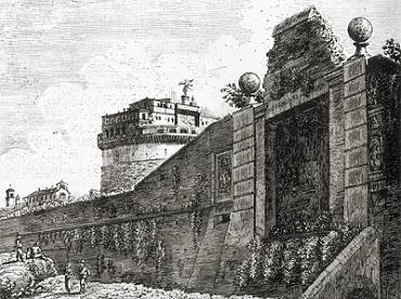
| Sometime later Porta Castello was closed and the bridge removed, in order to defend Porta Angelica alone, which remained the only approach to the city along this wall. No sooner than 1875, when Rome was no longer under the papal administration, the gate was opened once again. In order to provide an easy communication between the two halves of the district, Pius IV had several individual archways opened along the old Passetto, left without a real defensive purpose, yet still concealing the walkable passage that leads from the castle to the pope's residence. Porta Castello, closed and without its bridge, at the beginning of the 1800s, → |
 |
|---|
Unfortunately, in 1888 most of the wall sponsored by Pius IV was completely taken down, from Sant'Angelo Castle to the Vatican (including the two gates), for the purpose of building new houses.
| Such alteration became necessary due to the abrupt growth of Rome's population, after the fall of the Papal State (1870) and the subsequent proclamation of the city as new capital of the Kingdom of Italy. Very few traces of the dismantled wall still exist; the fragment shown on the left, coming from one of its dedication plaques, hangs as a decoration in the hall of one of the aforesaid buildings now standing along the direction of the old boundary, were the wall once ran. The text (which may be incomplete) reads:
PIUS THE FOURTH MEDICI MILANESE, POPE IN THE YEAR 1563 |
 the surviving fragment of a dedication plaque from the no longer extant wall of Pius IV |
|---|
The street plan of the district would still be the original one, if between 1936 and 1937 its whole central part, known as spina di Borgo ("Borgo's spine"), had not been taken down quite abruptly for the making of via della Conciliazione.
 (above) the district as seen from St.Peter's in the early 1900's: Old Borgo is still standing at the bottom of the square; (below) the same view as above today shows the deep cut, carried out in the 1930s, after the Concordat was signed  (by courtesy of Kalervo Koskimies) |
This wide avenue, that now connects St.Peter's Square to the castle and to the western bank of the Tiber, was planned a few years after the Italian government and pope Pius XI signed a concordat (1929), by means of which the Vatican State gained its independence. The purpose of the avenue was to act as a scenographic approach to the basilica. Such token of friendship payed to the newborn state completely disregarded the impact that such a radical change would bring to the old district. The avenue, in fact, caused the loss of the breathtaking view of the vast square and the huge basilica suddenly appearing from the shadows of the narrow lanes, a sensational effect that was part of Gianlorenzo Bernini's original project for the arrangement of St.Peter's Square (1656-67). This alteration is today strongly criticized, but nothing could be done to retrieve the original look of the district. See also Borgo in The Rioni section for a description of what was left.
|

