 |
 ~ Roman Monographs ~ Aqueducts · part III · page 2a |
|
|---|


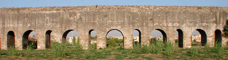
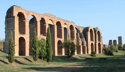
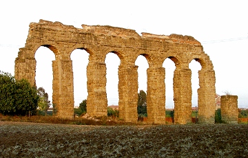
the long series of arches of the Acqua Felice, by vicolo dell'Acquedotto Felice
These three aqueducts are dealt with together because their direction through the urban area is in common. A brief description of each of them is necessary to understand how they combine together (see below, map of Rome's eastern surroundings).
The Aqua Marcia was the third aqueduct ever opened and the longest of them all (91 Km, or 61.7 Roman miles); it ran underground for 90% of its length. It was built in 144 BC and named after the praetor Quintus Marcius Rex who cared for its making. Its water was renowned for its purity and good taste. The springs were located north-east of Rome, between the present Vicovaro and Subiaco. By Vicovaro it flowed past the springs of the Anio Vetus aqueduct (the second one ever built, which ran entirely undergound). It then touched Tivoli, before making a southwards bend, in order to reach the hills south-east of Rome, from where it entered the city.
| The Aqua Tepula was built a couple of decades later (125 BC); its springs were located in the hills south-east of Rome, between the present Grottaferrata and Marino. It was named tepula ("warm") because of the temperature of the water, 16-17°C, whereas all the other waters were much colder, and in particular the aforesaid Aqua Marcia: an anecdote about emperor Nero says that one summer he bathed in its springs and almost lost his senses! | 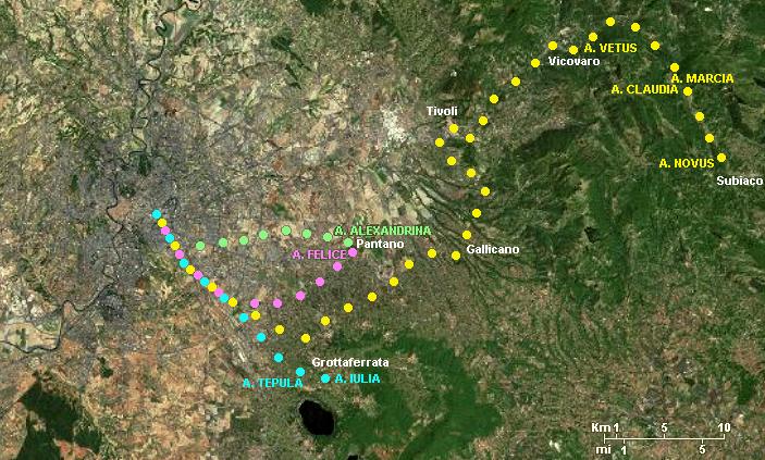 |
|---|
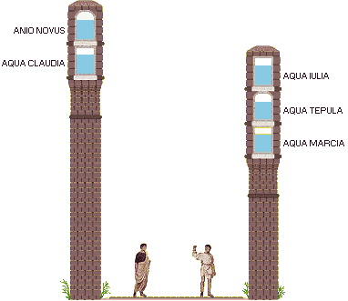
Also the Aqua Iulia (33 BC), named after the gens (family) which Julius Caesar and emperor Octavian Augustus belonged to, had its springs in the same area, near the Lake of Albano; in fact, together with the Aqua Tepula, flowing towards Rome they both merged with the Aqua Marcia, in order to exploit its already standing structure: they ran each through an individual tunnel, located respectively in the central part and in the top part of the attic (see the scheme below).
| The Aqua Claudia and the Anio Novus were built simultaneously, from AD 38 to 52. The first of the two was named after emperor Claudius, under whose reign the works were completed, while the second one was named Anio after the old Latin name of the river Aniene, whose course it followed; but since another aqueduct with a similar name - and a similar course - was already extant, the latter was renamed Anio Vetus ("old Anio"), while the other one was labelled Novus ("new"). The Anio Novus was quite longer than the Aqua Claudia: respectively, almost 87 Km equals to 58.7 Roman miles vs. almost 69 Km or 46.4 Roman miles (as the ancient incription above Porta Praenestina says). But both of them were shorter than the Aqua Marcia, whose course was more irregular. The Aqua Claudia ran underground for about 4/5 of its length, and the Anio Novus did so for an even longer part. As they approached Rome, they flowed above the ground level, using the same set of arches, which had two tunnels: an upper one for the Anio Novus and a lower one for the Aqua Claudia. The height that this structure reached on some spots was amazing. |
 |
|---|
The Acqua Felice aqueduct was built several centuries later, in the late Renaissance age, under the sponsorship of pope Sixtus V; in fact, its name is no longer in Latin but in Italian. The pope was called Felice Peretti, so the aqueduct was given his first name, which also makes it sound as "happy water". Its overall length was 28.7 Km. Its springs were the same ones that had been used by the Aqua Alexandrina (described in page 3), but its direction pointed towards the south-west, running underground; in the area known as 'Roma Vecchia' (now in Aqueducts Park) it emerged; on this same spot the Acqua Felice joined the course of the aforesaid Aqua Marcia and Aqua Claudia, already ruins by that time. Here the makers took away from these old structures all the building material they could find, using it for building the new aqueduct over the scanty remains; in this way, the Acqua Felice literally replaced most of the Aqua Marcia aqueduct and some parts of the Aqua Claudia.
This is why, unfortunately, within the urban area, little is left of the Aqua Claudia, and practically nothing of the Aqua Marcia. Instead the Renaissance aqueduct is still standing for its entire length (see the opening picture); its arches can be easily told from the ancient Roman structures, being much more plain and simple, sometimes with a variable distance between the pillars, and definitely lower than the older ones.
In order to trace the ancient Roman parts still standing, the Acqua Felice acts as the mythical Ariadne's thread, guiding the way through the faraway suburbs, where more substantial parts of the Aqua Claudia still exist, as well as a few of the Aqua Marcia.
A last important note: these pages describe the aqueducts from Rome towards the city outskirts, i.e. according to the opposite direction in which the water flowed.
Since ordinary maps for tourists usually do not include these districts, for those who would like to follow on foot the whole way, Virtual Roma provides a very detailed map, easy to follow and divided into three parts. The map also shows the local subway stations (
 ) and the stops of the Roma-Pantano urban railway line (
 ).
).


TO THE APPIO CLAUDIO DISTRICT
(see map parts I, II)
 the Acqua Felice springs off Aurelian's Walls wall by a tower; from this spot it followed the remains of the Circus Varianus for about 400 m (Ľ mi) |
The Acqua Felice aqueduct reached Porta Maggiore following Aurelian's Walls for about 350 metres (or yards) along via Casilina, crossing the area once called ad Spes Veterem ("by the Old Hope", after the temple of Spes Vetus), until the wall makes a bend at right angles towards the west. On this spot the Renaissance aqueduct leaves shortly the original course of the Aqua Claudia and follows the foundations of the Circus Varianus (highlighted in green in the map); it was an arena for chariot races that belonged to the Sessorium (the imperial residence), which Septimius Severus had built, and was completed under the reign of Helagabalus, in c.AD 220. The circus rapidly fell into disuse only half a century later, when the making of Aurelian's Walls cut through the arena; today nothing is left of the circus, except scarce underground traces. |
|---|
| Along this stretch, the Acqua Felice boundaries the parking lot of a supermarket, then it crosses piazza Lugo and then runs along via Lanusei, dividing it into two halves. On leaving the circus oval, it joins once again the original route of the Aqua Claudia, but now some houses conceil its arches for about 150 metres (or yards), Then it appears again along via Casilina Vecchia, crossing three times a railway junction. Here large modern arches opened in the 1900s have replaced a few original ones, in order to let the trains pass; instead, the pillars of the Acqua Felice still standing show some features clearly indicating that they once belonged to the Aqua Claudia: their shape forms an indent at the top, where they join the arches, and on their sides are rectangular prints left in the mortar by the stone blocks they were once lined with (picture on the right), which have been removed and recycled during the Renaissance; the old concrete, with large irregular stones, is often visible, as well. Once passed the railway junction, the aqueduct can only be followed along its western side, as its other side belongs to private properties. |
further along via Casilina Vecchia, it leans again on the remains of the Aqua Claudia, whose pillars still bear the print of stones that were removed 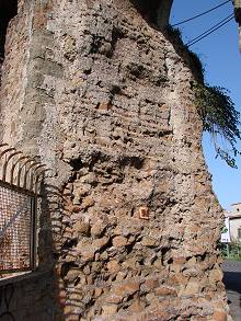 |
|---|
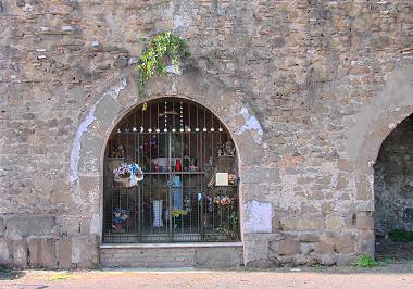 |
At the very beginning of this road, on the corner with vicolo del Mandrione, opposite the aqueduct, what looks like an ordinary wall, at a more careful inspection reveals the presence of a texture (now largely disrupted) with very old bricks, small blocks of tufa and even a few fragments of marble: these are the very poor remains of the Aqua Marcia that once ran by this spot, parallel to the Aqua Claudia (i.e. to the present Acqua Felice). The hight of the aqueduct along this stretch appear much lower than before, due to the rising of the ground level. Most archways have been either walled up or closed with iron nettings, to protect the private properties at the back; one of them has even been turned into a shrine (left). |
|---|
After a while, by a crossing with via della Marrana, the aqueduct and the road partly diverge, both making a slight bend in opposite directions, thus remaining separated by some further private estates. The Acqua Felice remains in sight, on the right, at a certain distance.
| As the road passes by the Casilina station, very soon, beyond a sports ground, some remains of the Aqua Claudia appear once again together with the Acqua Felice: the ancient structure is clearly taller than the latter, and covered with the typical large stone blocks. Here the Roman aqueduct, as well as the Renaissance one that leans against it, start converging again towards via del Mandrione. A few metres further, by a crossing with a short slope that links via del Mandrione to via di Porta Furba, unexpectedly some arches of the Aqua Marcia are still standing, side by side with the better preserved Aqua Claudia. However, they are barely visible, as they are completely covered by a thick spontaneous vegetation, and also because they stretch through private grounds. From this spot up to the end of via del Mandrione, all the aqueducts run once again along this road which, interestingly, exactly overlaps the direction of the ancient service passage that once ran between the Aqua Clauda and the Aqua Marcia. |
 the Aqua Claudia in via del Mandrione; the double arches and the additional brick layer are due to restoration works (2nd-3rd centuries); on the far right, the Acqua Felice separates from the older aqueduct |
|---|
It is worthwile mentioning that also the no longer extant Anio Vetus, an entirely underground aqueduct, once ran where today is the railway line.
Quite abruptly, the Acqua Felice separates from the Aqua Claudia and makes a bend at right angles (spot 1 in the map below), crossing the modern carriageway, and then following the opposite side of the road, where the arches of the Aqua Marcia once stood. So, for about 100 metres (or yards), on the right side of via del Mandrione the Aqua Claudia stands alone (picture above); most of its pillars look thicker than the upper part of the aqueduct, having been faced with large stones, and the archways are partly obliterated by a layer of bricks: these are the traces left by several reinforcement and restoration works, carried out from time to time throughout the imperial age.
On the left side of the road, instead, runs the Acqua Felice, which almost completely replaced the Aqua Marcia; the only scanty traces left of the ancient Roman structure appear at ground level, in the shape of a few brown stone blocks, i.e. the base of the no longer standing pillars.
Very soon the Acqua Felice makes a similar bend in the opposite direction (spot 2), crossing the road again to adjoin the Aqua Claudia.
 the Acqua Felice crosses the road and adjoins the Aqua Claudia (spot 2 of the map) |
Where via del Mandrione comes to an end, slightly further, the Acqua Felice and the Aqua Claudia separate again in the same way (spot 3), keeping parallel directions. On this spot, where a short part of the Aqua Claudia is missing, the Acqua Felice crosses via Tuscolana (the wide road running on the left and on the right) forming a special archway (A) that celebrates pope Sixtus V, the sponsor of the aqueduct. By doing so, the pope retrieved an ancient custom, once adopted also by Roman emperors when the aqueducts whose making they had sponsored crossed important roads. |  A - Porta Furba B - fountain of Clement XII
|
|---|
The arch of Sixtus V is known as Porta Furba, as if it were a city gate; the etymology of this name, though, is uncertain: some suggest that it may be a corruption of the term forma, which in a few Renaissance maps the aqueducts were labelled with; others maintain that it comes from the Latin fur ("thief") due to brigands and outlaws that once haunted this area.
| Unfortunately, the ancient arch by which the Aqua Claudia too once crossed via Tuscolana went lost; according to historical sources it was made of white travertine. In fact, a local road, as well as the nearest subway station, are called Arco di Travertino, i.e. "travertine arch". Another interesting feature is the fountain with a grotesque face with bat-like wings that pours the Acqua Felice water into a small basin (B).
|
 (↑ above) Porta Furba, where the Acqua Felice crosses via Tuscolana; (← left) a lion's head, heraldic device of Sixtus V, decorates the arch |
|---|

 this complex at the end of via del Mandrione includes (from the left) the Acqua Claudia, the fountain of Clement XII and the arches of the Acqua Felice up to a few metres before Porta Furba |
Of the three, only the fountain in via Tuscolana, once popularly called 'the pretty fountain', has survived, although not even this one is fully original: in fact, over two centuries later, due to its bad conditions, in 1723 pope Clement XII had it altered and enlarged, what can be read in the inscription on its front. Ever since, the people called it 'the fountain of Clement XII' (...and no longer of Sixtus V). Immediately after Porta Furba, some more remains of the Aqua Claudia stretch for about 150 metres (or yards); here the archways are almost completely blind, having been filled up with bricks, what makes them look more like a wall than an aqueduct. |
|---|
This is likely the result of one or more restoration works carried out in the late imperial age (AD 300-500): bricks were used to prop the pillars, which had become unsteady.
| Over one thousand years later, in the late 1500s, the architects that built the Acqua Felice entirely removed what was left from the Aqua Claudia, so that only the additional brick texture remained in place. Therefore, what we see today along this stretch is basically a huge, impressive mould of the original structure, whose pillars and arches are now missing, but whose shape can be still told by the clear print left in the surviving structure. the brick mould of the pillars and arches of the Aqua Claudia → |
 |
|---|
 the Acqua Felice along vicolo dell'Acquedotto Felice |
Shortly further from this spot, the Aqua Marcia gave off a branch called Aqua Antoniniana, built in the early 3rd century under Caracalla, whose purpose was to reach the famous public baths named after the same emperor; one of the very few surviving fragments of this branch is the so-called Arch of Drusus, located along the via Appia (see Aurelian's Walls, part III, page 2). As the mould of the Aqua Claudia comes to an end, the Acqua Felice, unbroken, crosses once again the modern roadway and keeps following one side of vicolo dell'Acquedotto Felice, a long and narrow road whose direction runs parallel to the aqueduct (picture onn the left). |
|---|
About 250 m (or yards) further, vicolo dell'Acquedotto Felice enters the grounds of a public park and turns into a path. From time to time, opposite the Acqua Felice, a few isolated yet still impressive remains of the Aqua Claudia can be seen through the trees.
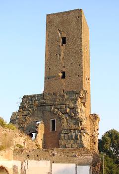
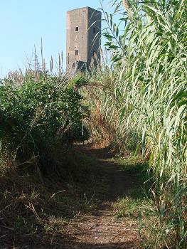
| Where the path comes to a junction, a short slope on the right leads to a nice series of arches belonging to the ancient aqueduct (right), heavily restored; the deep rectangular prints along the pillars are the traces left by the large stones taken away in different ages, and reused for other works (in particular, for the making of the nearby Acqua Felice). Following again the Acqua Felice, the path grows rather narrow, and about 150 metres (or yards) further off the city the aqueduct reaches a 13th century tower. |
 surviving arches of the Aqua Claudia; Torre Fiscale comes into sight (far right) |
|---|
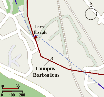 |
It was built on the spot where the Aqua Claudia and the Aqua Marcia, due to the need of maintaining the tunnels they supported at a certain hight from the ground, crossed each other at right angles, thus exchanging their respective positions. About 200 metres (or yards) south-east of this spot, the two aqueducts crossed each other again (see map on the left). In doing so, they enclosed a trapezoid-shaped area between the tower and the second crossing. The Ostrogoths led by Vitiges, who set siege to Rome from 537 to 538, walled up the arches along this stretch of both aqueducts, and used the area as one of the several camps that had been set around the walls on strategic spots; in this way they prevented the city from being reached by provisions. ▬▬▬▬▬ Aqua Claudia ▬ ▬ ▬ missing parts of the Aqua Claudia ▬▬▬▬▬ Acqua Felice (built over the Aqua Marcia) |
|---|
 the northern side of Torre Fiscale, featuring the Aqua Claudia archway |
Therefore, the land between Porta Furba and Torre Fiscale was later named Campus Barbaricus ("barbarian field"). An account of the siege was left by historian Procopius of Caesarea (see below), who witnessed these facts personally. Remains of the two ancient aqueducts can be told in the lower part of the tower. Very little is left of the Aqua Marcia, but on the side looking towards the north, one of the Aqua Claudia's arches is clearly visible, and on the western side also its water tunnel can be seen, while the upper tunnel that ran above the same aqueduct, i.e. the Anio Novus, is no longer open. Instead nothing is left of the Aqua Marcia, which has been entirely replaced by the Acqua Felice, that runs straight through the base of the tower. |
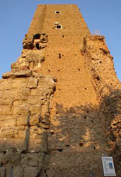 the western side of Torre Fiscale: note the Aqua Claudia's water tunnel, still open |
|---|
And the Goths, perceiving this, no longer cared to risk a decisive battle with their enemy, but they kept guard that nothing in future should be brought in to them. Now there are two aqueducts between the Latin and the Appian Ways, exceedingly high and carried on arches for a great distance. These two aqueducts meet at a place fifty stades distant from Rome and cross each other, so that for a little space they reverse their relative position. For the one which previously lay to the right from then on continues on the left side. And again coming together, they resume their former places, and thereafter remain apart. Consequently the space between them, enclosed, as it is, by the aqueducts, comes to be a fortress. And the barbarians walled up the lower arches of the aqueducts here with stones and mud and in this way gave it the form of a fort, and encamping there to the number of no fewer than seven thousand men, they kept guard that no provisions should thereafter be brought into the city by the enemy.
excerpt from Procopius of Caesarea, Gothic War - Book II, chapter III |
By Torre Fiscale the path (still officially called vicolo dell'Acquedotto Felice) comes to an end; in order to go any further, either of the two following directions can be taken. The first one is shorter, and it is also more beautiful from an environmental point of view, as the following pictures clearly show; but since it crosses some rather isolated grounds, with no electric lighting, it is a good thing to have an alternative route to choose.
| First direction (marked in purple in the large map) Go round the tower and take the pathway starting from its rear, which adjoins a sports ground on the right. As you keep going, every now and then it is advisable to turn round and enjoy the nice view of the tower overlooking the vegetation. Where the path meets a short tunnel below a railway line, it turns to the right.
|
 Torre Fiscale from the path at the back of the tower |
|---|
| Second direction (marked in pink in the large map) Just past Torre Fiscale, take the narrow road on the right, that slopes down gently for about 150 metres (or yards), making two ample curves and finally reaching the broad and busy via Appia Nuova by a car dealer. As you walk along this way, by turning your eyes towards the south-west you will clearly see in the distance another stretch of Aqua Claudia. Take via Appia Nuova on the left (i.e. southbound, opposite the city centre); about 800 metres / yards further, the road comes to a junction with via del Quadraro: by following this road, you'll cross the archways of a railway viaduct, then you'll come close enough to the aforesaid stretch of Aqua Claudia, located at the back of a sports ground. Finally, you'll pass over a second railway line, on the spot where this direction joins the previous one. |
 some arches of the Aqua Claudia by the railway line |
|---|
keep following this tour in page 2b →
| ~~ page 1 ~~ AQUEDUCTS BY THE CITY WALLS |
~~ page 3 ~~ AQUA VIRGO AQUA TRAIANA AQUA ALEXANDRINA |
|---|
part I
part II
part IV
