 |
 ~ Roman Monographs ~ Aqueducts · part III · page 3 |
|
|---|


AQUA VIRGO / ACQUEDOTTO VERGINE
| The Aqua Virgo (Maiden Water) was built in 19 BC in order to provide with plenty of water the Baths of Agrippa, the first public baths opened in the city. Its name comes from a legend according to which the Roman soldiers who were looking for good springs, were told were to find them by a local maiden. It is the only aqueduct in Rome that has always been working since its opening. |  map featuring the course of the ancient Aqua Virgo (yellow dots) and that of its modern 'clone', the Nuovo Acquedotto Vergine Elevato, opened in 1937 (cyan dots) |
|---|
Its springs are located by Salone, an area about 10 km (6.5 mi) east of ancient Rome, now in the faraway outskirts of the modern city, just beyond the outer ring road.
| The tunnel follows Via Collatina westwards, up to the present Casalbertone district; it then makes a sharp bend towards the north, crossing Via Tiburtina by the modern Pietralata district, and then it curves again towards the west. On reaching the hills now belonging to Villa Ada, it changes direction towards the south-west, running over the top of the Pincian Hill, through the grounds of Villa Borghese, and finally it comes down towards the Campus Martius plains, where it once ended right behind the Pantheon, for a total length of about 21 km (13 mi). The water tunnel reaches the city after an almost entirely underground course; originally, it ran above arches only for the last two kilometres, crossing the Pincian Hill and the urban part of ancient Rome (right). After the 6th century, the Aqua Virgo was left the main source of running water in Rome, yet with a reduced flow, so in order to keep it working, it was restored and partly altered several times. The earliest works were sponsored by pope Hadrian I in the late 8th century. |
 a map of 1590 features the no longer standing remains of the Aqua Virgo viaduct (highlighted in yellow), crossing the Pincian Hill towards the Campus Martius |
|---|
 the underground tunnel of the aqueduct, not far from its springs |
Over the years, the last stretch of Aqua Virgo stopped working all the same; so by the late Middle Ages, the aqueduct's outlet was no longer to be found by the ancient baths, but about 800 m (half mile) before reaching the Pantheon, on a spot where, according to some historical sources, stood a small fountain, that was enlarged in 1453, on the occasion of a second restoration, sponsored by Nicholas V. A further major restoration (1559-70) that enabled the making of a new network of water ducts in some of Rome's districts, also retrieved the aqueduct's original springs, in the Salone area; therefore, for some time the Aqua Virgo was renamed Acqua di Salone (Salone Water). But then the old name was adopted again, in its Italian form Acquedotto Vergine. |
|---|
In 1735, the aforesaid fountain underwent a dramatic change, being turned into one of Rome's most famous landmarks, the Trevi Fountain, whose making took thirty years. After its opening, the people started referring to the Aqua Vergine also with the popular name Trevi Water.
In 1753, while the making of the monument was still in progress, Benedict XIV had the aqueduct restored again, and other minor repairs were carried out under Pius VI in 1788.
| Such works were usually remembered by hanging plaques, some of which are still in place, such as the ones featured on the right. Over the last decades of the 1800s, the city considerably expanded beyond its old boundaries. To meet the increased need of water, in 1932-1937 the aqueduct was doubled by opening a second one, called Nuovo Acquedotto Vergine Elevato (New Elevated Acquedotto Vergine), with a tall water tower built by the natural springs, in order to considerably increase the hydraulic pressure required for propulsion. Its direction partly follows the first stretch of the old aqueduct (see map above), but it then runs more straight across the central districts, reaching its final output with a much shorter overall length of 13 km (8 mi). |
|
|---|


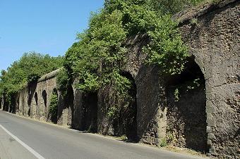
 surviving arches of the ancient Aqua Virgo in central Rome |
Along the Pincian Hill, the course of the old aqueduct runs below the 16th century Villa Medici (see also Legendary Rome, page 3), where a 25 m (82 ft) deep well was built, with a long spiral staircase along its sides, in order to reach the original tunnel. A similar one (without a staircase) was also built in the garden of the mansion. Today the tall viaduct that carried water through the city to the public baths has almost completely disappeared; the only fragment that can be seen consists of four arches built in white travertine, buried for most of their height several metres below the present ground level, which over the centuries rose considerably; they are barely noticed from the street, in via del Nazzareno (picture on the left, not far from the Trevi Fountain), between the buildings. On the opposite side of the street, a small 15th century door bearing the coat of arms of pope Sixtus IV leads to the ancient tunnel of the aqueduct; the passage is still in use for maintainance works. |
|---|
Other remains belonging to the same aqueduct were discovered by the foundations of nearby historical buildings, such as Palazzo Sciarra, but they are not accessible to the public.
 |
Instead nothing is left of the special archway by means of which the aqueduct spanned across the urban part of the Flaminian Way (presently via del Corso); it was known as Arch of Claudius, as in AD 51 it had been decorated to remember the conquest of Britain by that emperor, which had taken place eight years earlier. Only a fragment of the large inscription that hung from its upper part is kept in the Capitoline Museums (right). ← the 15th century door that leads to the water tunnel of the old aqueduct |
") fragment from the Arch of Claudius |
|---|
During the reign of emperor Trajan (AD 98-117), despite nine aqueducts were already working, the district on the western side of the Tiber, Trans Tiberim, had been left without a supply of drinkable water. The only aqueduct that reached Rome from the north-west was the Aqua Alsietina, which ran almost entirely underground, except a very short part.
 the Aqua Traiana's course (dotted line) |
Having been been built with the main purpose of filling emperor Octavianus Augustus' naval stadium (see Curious and Unusual page 4), the water it drew directly from the small Lacus Alsietinus, now Lake of Martignano, was not suitable for drinking. Trajan sought for clean springs in the same area, finding them by the hills on the western side of the Lacus Sabatinus (now Lake of Bracciano). Minor springs located on the eastern side of the lake were also used, so that the first stretch of the aqueduct followed about half of the lake's perimeter. The Aqua Traiana was completed in AD 109. Trajan bought all the grounds crossed by the aqueduct, so that the tunnel could always run through a protected area 30 feet in width, from the lake all the way down to Rome. Its tunnel was at ground level for most of its course; approaching the city, though, some parts ran above an aqueduct. The aqueduct entered Rome from the Janiculum, and the final outlet was located at the very top of the hill, one of the city's highest spots, where the Aurelian way approached Trastevere from the west, and where Aurelia Gate was built around 275 (see also Porta San Pancrazio). |
|---|
| The Aqua Traiana remained functional until 537, when the Goths damaged Rome's aqueducts. During the Middle Ages it was reactivated several times, but it never worked steadily again, until it was completely restored and partially rebuilt in the early 17th century. By that time, along the Aqua Traiana, renamed Acqua Paola, small stone pyramids were set at regular intervals, marking the openings of the tunnel's roof used for maintainance works. What is visible today within the urban area are three parts of the aqueduct, belonging to its last mile before the final outlet. They follow via Aurelia Antica, the modern road corresponding to the ancient roman Aurelian way, still narrow in some parts, and sometimes congested with traffic. |
 the aqueduct along the Aurelian way |
|---|


the red lines indicate the visible parts of the aqueduct
 the commemorative archway of Paul V |
Along the first part, i.e. the one once closer to the final outlet, the aqueduct reaches its maximum height, about 6 metres (or yards), not very tall, compared to other aqueducts. This stretch of the Aqua Traiana marks the boundary of a large public park, Villa Pamphilj; once this was the suburban residence of the Pamphilj family, whose most outstanding member was pope Innocent X (1644-55). Where via Aurelia Antica makes a slight bend, the aqueduct crosses the road thanks to an archway, whose look is clearly not ancient roman. Pope Paul V had it built in 1612, when the Aqua Traiana was restored; in the upper part of the archway, his commemorative plaque and family coat of arms remember his sponsorship. |
|---|
| The text, though, reveals a curious mistake: according to the third line, that reads
AB · AVG · CAES · EXTRUCTOS ("built by emperor Augustus"), the pope and his architects wrongly believed that what they had just restored was the Aqua Alsietina, actually built by Octavianus Augustus for his naval stadium, not the Aqua Traiana. The same mistake is also found in the even larger inscription above the huge Fountain of the Aqua Paola (see The Rioni, Trastevere). On the right side of the road (walking westwards), the aqueduct gradually turns lower and lower, until the series of arches disappears quite abruptly. |
 detail of Paul V's commemorative plaque |
|---|
Very soon the road goes slightly uphill, then downhill again; immediately past this spot, the aqueduct appears again, on the southern side of the street. Extremely low at first, it grows gradually higher until it acts once again as a boundary wall of Villa Pamphilj; in fact, the main entrance to the park is located below one of the aqueduct's arches.
 the third visible part of the aqueduct |
The last part of this stretch is barely recognizable, because the brick texture of the aqueduct has been covered with plaster, and appears smooth, as an ordinary wall. Then, by a crossing, the Aqua Traiana comes to an end again. The third part stands about 200 metres or yards further west, by the crossing with via del Casale di San Pio V, next to a block of modern buildings. The aqueduct can be told by the series of arches, whose uppermost part emerges from the ground for about 1 m (3 ft), remaining very low. Here the visible part of the structure is no more than 3-3.5 metres or 10 feet high, and it corresponds to the actual water tunnel, whose average height (inside) was about 2 metres or 6 feet. |
|---|
On the corner where the aqueduct makes a bend, turning towards the north-west, a surviving pyramid rests above the tunnel's roof.
|
 |
|---|

 the direction of the Aqua Alexandrina: the last part ( o o o ) is hypothetic |
The Aqua Alexandrina was the last aqueduct built in ancient Rome, in AD 226, over 500 years after the first one. Its purpose, according to emperor Alexander Severus who was the sponsor, was to carry water to the Baths of Nero, which stood in the western part of the Campus Martis, more or less where today is piazza Sant'Eustachio (see The 22 Rioni, page 8). The new aqueduct drew water from springs located about one mile south of the via Praenestina, east of Rome; its direction was initially almost parallel to the same way, then it made a slight bend towards the south, heading towards the via Labicana (today, via Casilina), and shortly before approaching the city walls it turned into an underground channel, and entered the urban area probably by Porta Praenestina (now Porta Maggiore); from there it likely followed the Esquiline hill, then the Quirinal hill, finally sloping down towards the plains of the Campus Martius. |
|---|
There are parts of this aqueduct still standing, up to where it crossed via Casilina, in Torpignattara district; the rest of its direction is hypothetic, as nearby (i.e. in via del Mandrione, see page 2a) stood also the Aqua Claudia with the Anius Novus, the triple duct of the Aqua Marcia, Tepula and Iulia, and even the Anius Vetus, although the latter ran below the ground level. The underground tunnel of the Aqua Alexandrina has never been found. None of its urban parts has been left standing, and the same aforesaid course is partially hypothetic because the underground duct has never been found.
| Within the urban area, the longest parts of the aqueduct can be seen in the eastern outskirts, whereas beyond the modern city boundary the aqueduct is still fairly preserved for most of its length. The first surviving stretch is located in viale dell'Acquedotto Alessandrino, where an unbroken series of arches crosses a public garden for 250 m (or yards). The structure is not in very good condition, but its overall look is still interesting. Its direction seems to converge towards the aforesaid via del Mandrione. the Aqua Alexandrina in Tor Pignattara district → |

|
|---|
 (↑ above) the tomb of St.Helen, or Tor Pignattara; (↓ below) a detail of the few pots left in the vault 
|
In via Casilina, not far from the south-eastern end of this part of aqueduct, another interesting and not too famous ancient remain can be seen: the monumental tomb of St.Helen, the mother of emperor
Constantine I, who died in 328 AD. It consists of a round hall built in bricks, with a tall dome (collapsed a long time ago), which stood by the entrance of a Christian underground cemetery, or catacomb, named after the saints Marcellinus and Peter. The inside has eight niches all around the hall; one of them matches the entrance, while the large sarcophagus in which St.Helen's body was buried, made of red porphyry (a marble only used for imperial family members), now kept in the Vatican Museums, stood in the largest niche, opposite the entrance. The central space of the hall is now occupied by a tiny church, Santi Marcellino e Pietro, built in the early 17th century. According to a particular technique in use by the late imperial age, the weight of the dome was reduced by inserting earthenware pots or amphors in the building material; a few of them are still there. This was worth St.Helen's tomb the popular nickname of Tor Pignattara (more or less "pot tower"), which also became the name of the whole district. In ancient times, instead, this site used to be called ad duas lauros ("by the two laurels"), because of two laurel trees planted by the large tomb, a symbol meaning that the building belonged to the imperial family. |
|---|
| The second surviving part of the Aqua Alexandrina is located about 1 km (0.65 miles) further east, at the southern end of another densely inhabited district, Centocelle. This stretch has more or less the same length as the previous one, but its outer brick texture is very well preserved. Luckily, the large and busy thoroughfare that crosses its central part, viale Palmiro Togliatti, does not affect at all the towering structure. |
 the Aqua Alexandrina in Centocelle district |
|---|
According to a building technique that had developed particularly during the previous century, the Acqua Alexandrina was no longer lined with large blocks of tufa, as most previous aqueducts, but with a layer of bricks; instead the inner structure, i.e. the tunnel that ran along the attic and the concrete that formed the core of the pillars, was the same as before.
Interestingly, a distinctive feature of the Aqua Alexandrina are four small white brackets made of travertine that protrude at the top of each pillar, just below the arch; their purpose remains obscure.
 (↑ above) the tunnel in cross section and its uncovered floor (right →) |
In Centocelle district the Aqua Alexandrina reaches its maximum height, over 20 m (about 65 ft) above the local ground level: in fact, on this spot the aqueduct once crossed a large ditch, which can be still partly told by the sloping streets that now follow the series of arches in both directions, i.e. via dei Pioppi, heading towards the city, and via degli Olmi, heading towards the outer suburbs. Along these streets, the pillars of the aqueduct grow lower and lower, up to the point that the attic lies at ground level. Particularly in via dei Pioppi, the tunnel that once ran along the attic is no longer extant, but a few metres or yards of its floor are still there, lying uncovered. A few fragments of the waterproof lining, almost 10 cm (about 4 in) thick, are also there, as well as some mortar: these remains provide a largely incomplete yet interesting cross section of the aqueduct's top part. |  |
|---|
Instead in the other street, via degli Olmi (see pictures below), where the surviving stretch of aqueduct comes to an end, are the remains of a medieval watchtower, with crenellation around its rooftop; a much taller and better preserved tower stands about 500 metres west of this spot, by via Casilina. Due to the presence of these towers, some claim that during the early Middle Ages the Aqua Alexandrina may have still been partly working: this would justify the need for such defensive structures to be built close to the aqueduct.
 the long series of arches heading towards the city; note the white brackets at the top of the pillars |
|
|---|


Those who would like to follow the very last traces of the Aqua Alexandrina within the modern city boundaries can keep walking along via degli Olmi, beyond the spot where the aqueduct disappears. About 200 metres (or yards) further east, the roads slopes downwards once again, and by a large crossing a fragment consisting of two arches indicates that here the aqueduct crossed another ditch, similar to the aforesaid one, but smaller.
 the Dives In Misericordia modernist church |
By the opposite side of the crossing, as via degli Olmi enters Tor Tre Teste district, a traffic barrier keeps vehicles away from the last part of the street, which a few metres further reaches a public park, named after the district; the ruins of a small building located immediately after the barrier likely belonged to a water cistern. Looking to the left, i.e. towards the north, at about 400 metres (Ľ mile), at the bottom of a modern neighborhood, the white 'sails' of the famous church Dives In Misericordia built by Richard Meier (2003) come into sight. It is indeed worthwhile to make a short diversion and visit this unique masterpiece of modernist architecture (...skipping abruptly some 1.800 years!), located so far from any part of the city normally reached by visitors. |
|---|
| Another extant part of the Aqua Alexandrina, about 150 metres/yards long, crosses the public park, emerging once again very gradually and reaching a maximum height of only 4 metres, very low compared to the previous stretch. Here its brick facing is almost completely lost, but the overall structure is better preserved than the one in Torpignattara district. |  the Aqua Alexandrina in Tor Tre Teste public park |
|---|
Then the aqueduct grows once again so low that the floor of its tunnel (the only part of the attic left) matches once again the local ground level, and then completely disappears.
Shortly beyond this spot, the public park ends with a slope that leads towards via di Tor Tre Teste; here are the ruins of another small building of Roman age, whose purpose remains unclear.
 one of the two aqueduct fragments not directly accessible |
It is advisable to end here the tour, although in a field located about 350 metres further east (but with no access to the public) two more fragments of the Aqua Alexandrina can be seen from the road that surrounds the estate (whose farther side is followed by the main ring road that runs all around the city). In order to return to the central districts, at the bus stop in the nearby via Angelo Viscogliosi, by the crossing with via di Tor Tre Teste, take bus no.556 towards via Casilina (you'll be able to see from the bus one of the two aforesaid fragments) and get off at the terminus; then at the local urban railway stop (Tobagi), located only a few metres away, in via Casilina, take the train towards Termini (the central railway station). |
|---|
The first of the two routes takes a shorter time.
| ~~ page 1 ~~ AQUEDUCTS BY THE CITY WALLS |
~~ page 2 ~~ AQUA CLAUDIA AQUA MARCIA ACQUA FELICE |
|---|
part I
part II
part IV
