


Starting from piazzale Labicano, some interesting Roman remains located in the nearby surrounding can be visited by making two short diversions.
|
 above and below left: Nero's aqueduct |
|---|
 |
The aqueduct can be followed for about 200 metres; by the crossing with via di Santa Croce in Gerusalemme it enters the grounds of Villa Wolkonsky, the residence of the British ambassador, where it becomes no longer accessible. Where the aqueduct was cut, some earthenware pipes that drew water from the main tunnel are clearly visible in cross section (their picture is featured in the Aqueducts monograph, part II). And on the opposite side of the crossing don't miss some more interesting remains concealed by an iron fencing: there stand two tombs [map ref. d], built in tufa stone, belonging to people of the middle class. |
|---|
 the tombs in via Statilia |
 a detail of the portraits |
The first one on the far left dates to the late 2nd century BC and is decorated with round shields carved on the front. The second and larger one from a slightly later age (early 1st century BC) has two windows that give light to two separate rooms inside, and two panels featuring the portraits of the five dead buried there. |
|---|
|
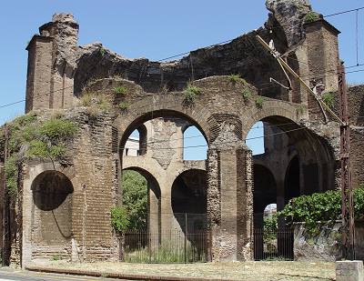 the so-called Temple of Minerva Medica |
|---|
| The so-called Temple of Minerva was its nymphaeum, an ornate building full of plants, flowers, sculptures and fountains, dedicated to water nymphs. The hall had a large and tall dome (part of which can still be seen) that collapsed in 1828; in ancient Rome it was the third in size after those of the Pantheon and the Baths of Caracalla. Old drawings and etchings earlier than its fall show what it previously looked like. |
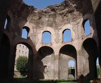 |
 (← left) the inside of the hall and (↑ above) the nymphaeum in an illustration of 1820, before the dome collapsed |
|---|
In the corner of piazzale Labicano from where via Prenestina starts, a few metres before the tunnel under the railway, is the entrance to a small underground basilica [map ref. f], discovered in 1917, which dates back to the 1st century AD and belonged to a Neo-Pythagorean sect. This site is not open to the public, although applications for a permit can be made by Rome's Archaeological Government Office (Soprintendenza Archeologica di Roma, piazza Santa Maria Nova, 53). Due to its location, the basilica is perfectly preserved, with very fine decorations in relief.
Back again along the main route, the wall makes a bend towards the south, following one side of via Casilina. Here we shortly lose sight of the wall for about 150 metres, as it crosses a private ground located above a grassy mound on the right.
This was the route of one of the most important aqueducts of ancient Rome, the Aqua Claudia, which originally reached Porta Maggiore, as previously mentioned in part 2; but when Aurelian had the set of walls built, its last stretch before the gate was included into the new difensive structure, therefore its arches disappeared.
 the Acqua Felice, just before it joins the wall; here its arches rest over the remains of the no longer extant Circus Varianus |
By the first crossing, the wall makes a bend at right angles towards the right, along viale Castrense. A few metres (or yards) further, by a tower, the wall is joined by another long series of arches [map ref. g] with a rather narrow span (about 2 metres in width), the Acqua Felice aqueduct, built in 1587, when pope Sixtus V thought of using what was still standing of ancient Roman buildings to build a new source of water for the city. For most of its length, the Acqua Felice followed the remains of the Aqua Claudia (among which the aforesaid ones, included in the wall), and also of the Aqua Marcia, that ran parallel to the former aqueduct (see the Aqueducts monograph); but along this very stretch it rests over ruins once belonged to the no longer standing Circus Varianus, described further in this page. Crossing the road, it is possible to follow the series of arches as they skirt the parking lot of a supermarket. |
|---|
Along viale Castrense, after another slight turn, the tall statues of St.John's basilica can be seen in the distance above the wall. A few metres further on, we come to another interesting building crossed by Aurelian's architects, the Amphitheatrum Castrensis [map ref. h].
 |
 |
|---|
Despite its small size, this was an actual amphitheatre made of bricks, used for games and shows. It is oval in shape, as the Colosseum, and it even had a velarium, i.e. a curtain that could be stretched over the seated area.
| Emperor Helagabalus had it built in c.AD 220, about fifty years before Aurelian's walls surrounded the city, in the grounds known as Horti Variani ad Spes Veterem, i.e. Variani Gardens by the Old Hope (the name of a temple that stood nearby). Several of the 48 half columns that decorated the outer surface, alternating with entrances (now closed), are still visible. Originally, the amphitheatre had two more orders (or storeys) above the surviving one, that were taken down around 1557. The inside is now used as a vegetable garden by the Cistercian monks and, at least in some parts of the year, it can be visited by appointment. By a passage connecting viale Castrense with piazza Santa Croce in Gerusalemme, in the corner where the wall joins the amphitheatre, on the inner side, stands a tiny church [map ref. i] named Santa Maria del Buon Aiuto (Saint Mary of Good Help) after a pre-existing chapel which used to receive generous offerings; pope Sixtus IV enlarged it in 1476, as mentioned by an old inscription above the door, apparently as a token of gratitude by the pope who one day, on paying a visit to the nearby Santa Croce's church, had found shelter there from a sudden and violent storm. |
 the Amphitheatrum Castrensis, in a map of ancient Rome (1576) |
|---|
 |
Close enough to the amphitheatre, on the side opposite to the small church, stood the Sessorium: this was a huge building, whose works had been started by Septimius Severus around AD 200, and then completed by Helagabalus around AD 220. It became the emperor's residence for about one hundred years, until Constantine I in AD 330 changed the capital of the empire from Rome to to Byzantium. By that time, emperor Constantine's mother, Saint Helen, turned one part of the palace into a Christian place of worship, which later in time developed into the present basilica of Santa Croce in Gerusalemme. The only surviving fragments of the Sessorium [map ref. j] belong to a wide hall with an apse, now standing in the grounds of the former Grenadier barracks (presently a Grenadier corps museum), on the left side of the church. ← the scanty remains of the Sessorium |
|---|
| Besides the aforesaid amphiteatre and the palace, the imperial complex also included a no longer standing arena for chariot races, called Circus Varianus, which stretched at the back of the Sessorium in an area called ad Spes Veterem ("by the Old Hope", after the name of a temple); the spine of the circus was decorated with the obelisk that today stands in the Pincio Gardens (see the Obelisks monograph). Along the scarce remains of its northern side, in the late Renaissance a stretch of Acqua Felice aqueduct was built. Keep following the inner side of the well preserved wall for about 300 metres (or yards), through a public garden. Here the ground level is rather higher than on the outside, as can be told from the narrow windows of some placements. |
 the last stretch of wall before the Lateran, seen from the inside |
|---|
As soon as a huge statue of St.Francis of Assisi comes into sight, piazza di Porta San Giovanni is finally reached. Cross again the wall, to the outer side.
In the middle of the vast square, among several new passages opened in the early years of the 20th century, stands Porta San Giovanni [map ref. 6]: this is a 'modern' door that pope Gregory XIII had built in 1574 by one of Michelangelo's apprentices, Jacopo (Giacomo) Del Duca, from Sicily.
 the wall with Porta San Giovanni, spanning piazzale Appio Together with Porta del Popolo and Porta Pia, it belongs to the group of Renaissance gates which, unlike ancient Roman ones, blended military defensive purposes with a rather lavish shape, for artistic reasons. Its archway, whose frame is decorated with a fake ashlar work, and the attic, shaped as a balcony, in fact mimic the doorway of a 16th century noble building, while the keystone features a curious moor's head. |
It stood along via Campana (as stated by the inscription above the archway), a road which ran towards
the south, along the direction now matching via Appia Nuova.  the keystone of the gate's arch |
In piazzale Appio the second leg of the tour ends. For those who wish to leave the tour now, in front of the gate, on both sides of the square, are the stairs leading to San Giovanni subway station (line A).
 |
 |
 |
 |
|---|