


The Janiculum is a long hill, whose steep side borders the western side of Rome's historical nucleus for about 2.1 km ~ 1.3 mi, near the river Tiber. A small part of the hill had already been enclosed by the city walls built under emperor Aurelianus (AD 275). But they had never been cared for during the following centuries, nor restored, because this part of the city had been abandoned; so some parts crumbled, some others were taken down when the district became once again inhabited, and only few remains were left standing, merely as relics of a bygone age.
 the end of Sangallo's bastion next to the tunnel |
When cardinal Maffeo Barberini was elected pope Urban VIII in 1623, he thought that this part of Rome was in need of a strong boundary; so he sponsored the making of a new set of walls stretching along the top of the hill, from the Vatican down to the riverside in the southern part of the city. This leg of the tour starts from Porta Cavalleggeri [map ref. 8], and follows the walls on the outer side; for a description of what can be found on the inner side, see the Rioni section, page 13. Take the road that climbs uphill, opposite the round tower, on the right side of the tunnel's entrance. You are now following the first part of the large bastion by Sangallo (described at the end of part II). |
|---|
| Where a large coat of arms of Pius V (1566-72) with diagonal bands hangs high above, the bastion makes its first bend, running shortly in a private ground, then bending again and crossing the Janiculum towards Porta Santo Spirito, on the other side of the hill. The new wall sponsored by Urban VIII joins the bastion by its second bend; it comes into sight along the side of the road a few metres further, although since the same kind of bricks and the same building technique were used, it shows no visible difference with the older structure. Here there is little space for pedestrians; usually, not many cars drive along this way, but it is wise to be constantly aware of the traffic. There are no particular features of interest along this first stretch. Nevertheless, what makes pleasant walking around the several arrow-shaped bastions is the genuine look of the wall, virtually unchanged after almost four centuries, as it would have appeared around 1630 to anyone who dared to venture beyond the Vatican Hill. |
 coat of arms of Pius V on the bastion |
|---|
 the old house built over the bastion |
No gate can be found along this part of the wall, except a few service passages, similar to the ones found along the western side of the Vatican (see part II page 1) In recent times (1950s-60s), a modern district has spread by the base of the hill, on the right side of the road; how high the Vatican stands above the surrounding area and how steeply its sides slope can be easily understood by the fact that the ground level by the wall is at the same height as the 5th floor of the nearby houses. Some 300 metres/yards ahead, as soon as you see an old house built over one of the bastions, the modern district on the right fades to trees and other vegetation, and the road becomes less steep. The most pleasant part of the walk starts from here. |
|---|
Very soon the tall monument dedicated to national hero Giuseppe Garibaldi comes into sight through the trees on the other side of the wall. You may also happen to see people leaning from the wall's top: the ground level on the inside is almost as high as the wall itself, having been considerably raised when the area became a public park.
 Garibaldi's monument |
Immediately before the fourth bastion, along the road stands a monument in the shape of a small shrine, dedicated to St.Andrew. For several centuries, the saint's skull was held by St.Peter's basilica as one of its most important relics. It had been brought to Rome from Constantinople in 1462, to avoid the risk of having it taken by the Ottomans. In 1848 the relic was stolen; but only a few days later it was found on this very spot. In memory of the retrieval, pope Pius IX set here a statue of the saint, covered by a canopy supported by four columns (originally, it was surronded by an iron railing). The shape of the monument was inspired by a very similar one, yet larger in size, built in the 15th century along the Flaminian Way, by the southern end of Milvio Bridge, to celebrate the arrival of the relic in Rome. |  the monument dedicated to St.Andrew |
|---|
The saint's head, though, is no longer in St.Peter's: in 1964 it was given back by pope Paul VI to Patras, the Greek city where the apostle came from, as a token of friendship towards the Greek Orthodox Church, in the attempt of improving its relations with the Church of Rome, at times rather cold.
| Curiously, in very recent years also the statue of St.Andrew was stolen from the monument (2006), and was then retrieved in Rome's surroundings, while in 2014 the marble skull endured the same fate; but it was found a few months later, and reinstalled on the monument. Finally, after the last bend, the road opens up into a large crossing: this is the spot where the ancient Porta Aurelia stood, i.e. the gate located along the Aurelian Way, the main route that connected Rome to the north-western territories. In time, it was renamed Porta San Pancrazio after the nearby church of St.Pancras [map ref. 10]. |
 ↑ in the old cannon placements now birds build their nests |
|---|
 the ancient Porta Aurelia, or San Pancrazio, in a map of Rome dated 1625 |
Remains of the Roman wall were still standing here in the early 1600s; Urban VIII had them taken down, and the ancient Roman gate was covered on the outside with a much more imposing front, in Baroque style (see the pictures on both sides). |  the refurbished Porta San Pancrazio (arrow) encased between two bastions built under Urban VIII, from a map dated 1676 |
|---|
|
|---|


In February 1849, the people of Rome uprose against the papal authority and upthrew Pius IX, establishing the short-living Roman Republic; only five months later, in July of the same year, a violent clash took place in this area between the Roman army, mostly formed by civilians and volunteers, and a corps of mercenaries, the Zouaves, sent by France, upon whom the pope had called for help. The damage caused by the siege to buildings and monuments all over the surroundings, including Porta San Pancrazio, was quite considerable.
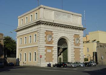 the new Porta San Pancrazio, built in 1854 |
The front built under Urban VIII was left in such bad condition (above right) that in 1854 it was taken down, together with what was left of the Roman gate, and was replaced by a new Porta San Pancrazio. The latter was built by architect Virginio Vespignani, in the shape of a stout cubic structure, crossed by an archway, which now stands in the middle of the crossing. The nice pair of coats of arms that hang from its front refer to Pius IX and Urban VIII. |
 coat of arms of Pius IX (Mastai Ferretti) |
|---|
In recent times, the bastion on the left side of the gate was partly cut, to let traffic flow more easily.
One more tangible memory of the battle - others will be seen, further on - are the ruins of the villa called Il Vascello ("The Galleon"), about 50 metres or yards off the gate, on the right hand side of via San Pancrazio [map ref. g]. Built in 1663, the villa was shaped as an actual war galleon, and also had fancy fountains, deforming mirrors, and other bizzarre features typical of the Baroque age.
 the Casino dei Quattro Venti (painting by Carl Friedrich Heinrich Werner) after the battle of 1849; some corpses are still left on the ground |
 the scars of the battle on the villa's outer wall along via di San Pancrazio |
|---|
Following the battle of 1849, its main building, called Casino dei Quattro Venti, was left so badly damaged that there was no solution left but to take it down. The scars left by the artillery on the villa's outer wall, as well as along the rest of the street, are still today very evident.
Back to Porta San Pancrazio, on the left, just by entrance of the public park that now stretches on the inner side of the wall, stands a curious feature: the lonely faþade of a house in late Renaissance style ...but without the actual building.
 the so called house of Michelangelo |
This is known as 'the house of Michelangelo" [map ref. h], because according to a popular tradition, this was the house where the famous artist dwelt in Rome. The historical truth, though, is a bit different. While in Rome, Michelangelo lived in Macel de' Corvi, a narrow lane located below the Capitolium Hill. In 1902, that district was subject to extensive demolition due to the making of the huge memorial dedicated to king Victor Emmanuel II; all the old houses were taken down, and among them was also the one featured in the picture, whose faþade was the only part spared, not because Michelangelo lived there (this is a legend), but simply because it was one of the most artistically interesting. At first, it was stood again on one side of the long staircase that leads to Capitolium Square; then, in 1941, it was finally moved to the Janiculum hill, where it now covers a water reservoir located on the back. |
|---|
 |
 |
 |
 |
|---|