


From Porta San Pancrazio, if you feel like making a 45 minute diversion (total distance 1.8 Km / 1.1 mi), you can cross the gate and follow via Garibaldi downhill, to the bottom of the Janiculum. The sites mentioned in this diversion are also described in The Rioni section, in the pages about Trastevere district.
Shortly beyond the gate, the road makes a round bend and reaches the famous Acqua Paola Fountain [map ref. i], better known in Rome as the fontanone del Gianicolo ("big fountain of the Janiculum").
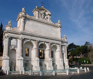 |
It was named after Paul V (1605-1621), the pope who sponsored its making in the early years of his pontificate. It was part of a major work, which included the reopening of the ancient Aqua Traiana aqueduct (see Aqueducts, part III page 3) by restoring the surviving parts and rebuilding the missing ones, in order to provide Trastevere district with running water. The fountain was set at the end of the main branch of the acqueduct. The enormous basin that collects the water from the five niches, though, was added about seventy years later. More detailed information can be found in Fountains, part III page 12. Don't miss the breathtaking view over the city from the terrace in front of the fountain. ← the large Acqua Paola Fountain |
|---|
| On the left side of the terrace, a steep flight of steps leads towards the lower part of Trastevere district; the old wall on the left hand side, partly covered with weeds, is actually one of the scarce parts left standing of Aurelian's wall [map ref. j], that once climbed along the Janiculum hill reaching Porta Aurelia (see page 1); its irregular texture indicates that it was refurbished or maybe entirely rebuilt over time, likely during the Middle Ages. A few more fragments of this wall now lie in private properties, and are no longer visible from the street. Follow the lane at the bottom of the staircase, which very soon merges with via Garibaldi; the latter makes a bend to the right and keeps running downhill for about 250 metres, towards the riverside. | 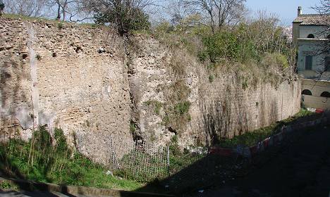 remains of Aurelian's wall, with traces of one of its towers |
|---|
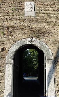
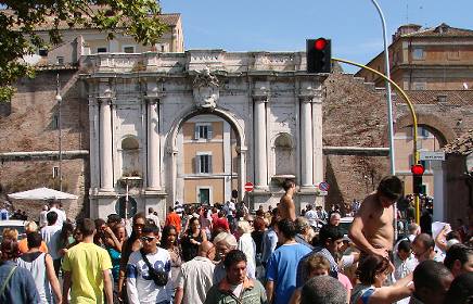
By the crossing at the bottom of via Garibaldi, on the left, you'll see an archway with crenellation in the top part. This is Porta Settimiana [map ref. 11], the only surviving gate of the Roman wall still standing on this side of the city.
It was given this name probably after emperor Septimius Severus, who though lived about 75 years before the wall was built; some sources suggest that one of the emperor's properties, or an arch bearing his name, might have stood nearby, whence the dedication of the gate. Pope Alexander VI (late 15th century), and later Pius VI (late 18th century), refurbished it into its present shape. Below the archway you can still see the creases where the portcullis originally ran.
On its left side hangs an old painting, so spoilt by time that the religious subject it featured can be barely told. A similar one one was on the inner side of the gate, but it has now completely disappeared.
 Porta Settimiana |
 the wall in vicolo Moroni |
|---|
For more hidden traces of Aurelian's wall, from Porta Settimiana follow via di Santa Dorotea and, at the first juction, take vicolo Moroni: on the left side of the narrow lane, a blind alley is closed at the bottom by a stretch of wall [map ref. k], with two surviving towers, one of which is visible. Here the wall acts as the boundary of the southernmost part of Villa Farnesina's gardens (for details about the villa, see The Rioni section).
To make your way back to the top of the hill, follow the narrow street opposite the gate, via della Scala, which leads into the heart of Trastevere district.
| As soon as a large madonnella shrine painted on the wall comes into sight, just before piazza Sant'Egidio, turn right along the lane called vicolo del Cedro, and keep following it up to its end. You will cross a few typical lanes at the base of the hill, and then reach a steep stairway. At the top of the stairs, you will find yourself again on via Garibaldi. Follow this winding road uphill, i.e. on the left, for a few metres (be careful of the traffic!); on the opposite side of the road, just before a sharp turn to the right, you will notice an iron gate that gives access to a passage, whose walls are pannelled with scenes of the Via Crucis (or Via Dolorosa, the road travelled by Jesus to Golgotha). The last part of the passage is a rather steep stairway that climbs towards a complex of buildings: the Spanish Academy in Rome and the church of San Pietro in Montorio [map ref. l]. |
 vicolo del Leopardo |
|---|
 satellite view of San Pietro in Montorio (left) and the Spanish Academy (right); note the small temple in the courtyard |
Montorio is an old name for the Janiculum Hill, used in the Middle Ages; the word is a contraction of the Latin mons aureus ("golden hill"), referring to the yellowish colour of the hill's sand. You can read about the church and its artistic features in The Rioni section, Trastevere.
In a courtyard adjoining the church you'll see the famous Small Temple: this is one of the most renowned works in Rome by Donato Bramante (1502), considered a masterwork of Renaissance architecture. The temple was built exactly over the spot where, according to a medieval legend, still alive in the 1500s, St.Peter's cross had been stood. Keep climbing uphill along via Garibaldi; very soon you'll pass by a memorial monument in white travertine [map ref. m], where the many who lost their lives defending Rome in the battle of 1849 are buried (see part II, page 2 for historical details). |
|---|
Shortly after the memorial, you'll find yourself once again by the big fountain.
Finally back to Porta San Pancrazio, the main route of the tour can be followed again, as the road gradually slopes downhill.
The next stretch of wall encircles the western and southern sides of Villa Sciarra, which stretches for 7.5 hectares or 18 acres along the southern side of the Janiculum. Around 1650, not long after these grounds were included within the urban boundary, a nephew of pope Urban VIII, who was a cardinal himself, bought the estate and turned it into a farm.
In the early 1800s the property came into the possession of the Colonna di Sciarra family, who held it for most part of the 19th century.
In the early 1900s, the last private owner, George Wurts (from the United States), refurbished the main building and set in the gardens several 18th century statues, some fountains, an aviary and other features. In 1930 Villa Sciarra became a public park. 
|
 ← a view of Villa Sciarra and its side entrance along the wall ↑ |
|---|
The main gates are on the opposite side of the villa, but a small service passage located midway between two bastions now acts as a side entrance to the gardens [map ref. n]: crossing its low archway, which features a Barberini bee on the keystone and a full coat of arms of Urban VIII further above, you can realize the amazing thickness of these walls.
In 1849, during Rome's siege, the heavy artillery of the French mercenaries whom the pope had called upon attacked rather fiercely this stretch of the wall; some lengthy parts, in fact, crumbled.
As soon as the papal authority was reinstalled, Pius IX had the damages completely restored; on this occasion, a few plaques were hung, as usual, to remember the works.
 one of the plaques dated 1849 |
 unrepaired damages: bullets are still in the wall |
But besides the papal insignia, instead of the coat of arms of the pope's own family, typically found in older plaques, these ones feature the city's motto S.P.Q.R. (Latin for "the Senate And the People of Rome") and the year 1849 in Roman numerals; historians believe that this may have been a token of respect by the pope towards the city, whose unrest and dislike for the papal authority was clearly still alive. |
|---|
Along the wall you can also see some large restored patches, told by the slightly different brick texture, and some minor damages that were left unrepaired.
| On the southern side of Villa Sciarra the road slopes downhill rather steeply, reaching a small terrace from which you can take a view over the district. From here, you may either follow the straight flight of steps, or walk along the winding road, down to the end of via Aurelio Saffi, where in the early 1900s the 17th century wall was replaced by modern buildings; a small fragment was left standing, just before the corner with viale Trastevere. For the making of this wide avenue, another part of the wall was taken down; but on the opposite side of the road you will see it standing again, along via delle Mura Portuensi. This last stretch is rather low, due to the considerable rising of the modern ground level. Where the road makes a slight curve, looking towards the opposite side of the road you will see in the distance the ancient church of Santa Sabina, perching high above the top of the Aventine hill. |
 restored patches of wall can be told by the slightly different texture |
|---|
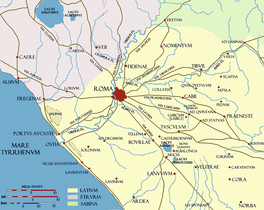
With a last turn to the right, the wall reaches the southernmost gate of Urban VIII's boundary, Porta Portese [map ref. 12]. Its original Latin name was Porta Portuensis, after via Portuensis, the ancient road that led to Portus; this was the main harbour of imperial Rome, founded in the 1st century AD after the sand carried by the Tiber had gradually silted up the older harbour, Ostia (see map of ROME'S ANCIENT SURROUNDINGS).
 Porta Portese, at the end of the wall built under Urban VIII; Rome's largest and most crowded flea-market is held here on Sundays |
You may notice that the heraldic shield hanging above Porta Portese does not feature the three bees of the Barberini family, as most other coats of arms found along this wall, but three lilies over a dove with an olive twig in its beak, i.e. the device of the Pamphilj family, who were bitter enemies to the Barberini in the struggle for power. |
 coat of arms of Innocent X (Pamphilj) over the archway of Porta Portese |
|---|
Actually, Urban VIII died shortly before the last part of the work was finished; so his successor Innocent X (Giovanni Battista Pamphilj) got the credit for having sponsored the making of this last gate.
Also the ancient wall built by emperor Aurelian in the 2nd century AD had a gate called Porta Portuensis, but this one stood about 750 metres or 800 yards away from this spot, along the same via Portuensis, as shown in the map below. Originally, it had a double archway, but in c.400 emperor Honorius reduced it to a single passage, in order to defend it more easily (the same happened to Porta Praenestina and Porta Appia).
| Porta Portese is the only site where the ancient city boundary was slightly shrinked by the new set of walls built under Urban VIII, instead of being enlarged. This choice was taken for strategic purposes: to defend it from the heights of the nearby Janiculum Hill would have been easier than with the gate located on its original spot. Up to the mid 1600s, the chosen site for the new Porta Portese had been used by Rome's Jewish community as a burial place. The making of the gate caused the cemetery to be removed. |
 detail from a map of 1590; the ancient Roman wall was still standing, with the original Porta Portuensis and the old Jewish cemetery, referred to as Campus Iudeorum ("Field of the Jews"); the blue line shows the direction of the new wall built in the 1600s, and an arrow indicates the site of the new gate, Porta Portese |
|---|
Here the tour of the walls of the popes comes to its end.
To reach the closest public transport line, walk back to viale Trastevere: tram no.8 will take you towards the city center (largo di Torre Argentina, not far from piazza Venezia). Otherwise, you can cross Ponte Sublicio (i.e. the bridge next to Porta Portese), and walk straight down the wide via Marmorata for about 800 metres or ½ mile: it will take you to the subway station Piramide (line B), located next to Porta San Paolo and Gaius Cestius' Pyramid (see Aurelian's walls, part III page 3).
 |
 |
 |
|---|