 |
  |
 |
|---|
|
|
|
|---|
 |
NAME Ripa is short for Ripa Grande ("Great Bank"), Rome's main river port, abandoned in the 19th century, which stood on both sides of the Tiber. Only the eastern bank belongs to this district, the western one being part of Trastevere (Rione XIII). In ancient Rome three regiones covered this area, namely the 11th (Circus Maximus), the 12th (Piscina Publica) and the 13th (Aventinus), while in the late Middle Ages this became Rome's eleventh district, called Regio Ripe et Marmorate; the name Marmorate referred to the river bank south of the Aventine Hill where, since the imperial age, rough blocks of different kinds of marble (marmora), shipped to Rome from the East, were stored in a large deposit area, called the emporium. |
 |
|---|
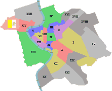
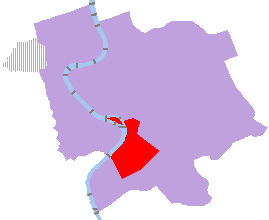
MAIN FEATURES (the black numbers in brackets refer to the map on the right) In the northernmost part of Ripa, where the district neighbours the Capitolium Hill, pre-roman traces were found, thus indicating that this area was already inhabited before the city was founded. |
 |
|---|
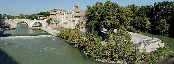 the southern end of the Tiber Island, from Palatino Bridge |
In the early days of the empire a number of rich mansions stood here but, as of the
5th century, the barbaric invasions caused their destruction, causing this area to be almost completely abandoned, with the exception of a few convents on the heights of the Aventine Hill, located on a safer spot. The district became again inhabited as of the Renaissance age, when sometime during the 16th century the river port called Ripa Grande [1] became active. |
|---|
Therefore, the dwellers of this district were mostly fishermen. Their rather poor houses and a number of deposits where goods were stored used to be the main type of buildings found in this part of Rome. Also a number of small river mills built on boats were moored along the banks of the Tiber Island [2] (mentioned in page 5 of the Curious And Unusual section). The port disappeared in the late 1800s, due to the making of the walls along the river banks, to prevent further floods. By that time, most local dwellers quit the district, and their old houses were taken down. In 1921 the southernmost part of Ripa was split, to become the twenty-first district, San Saba. Today, Ripa is an archaeologic site for most of its extension, still rather large. |
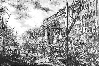 Ripa Grande in the 18th century (etching by G.B.Piranesi) |
|---|
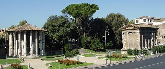 Two well-preserved ancient buildings by the river bank are small temples [3] from the 2nd century BC, whose names were originally mistaken but are still in use. The first one is the so-called Temple of Vesta, a wrong title due to its round shape, similar to that of the Vestal shrine in the Roman Forum, though actually dedicated to Hercules. The other one is known as Temple of Virile Fortune, but its actual dedication was to Portunus, a minor god of the rivers. During the Middle Ages both temples were turned into churches. |
 the house of the Crescenzi |
|---|
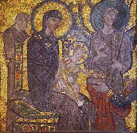
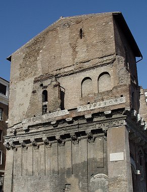
On the opposite side of the road, stands the Romanesque church of Santa Maria in Cosmedin [5], originally called Santa Maria in Schola Greca ("St.Mary by the Greek School") as during the early Middle Ages this area was inhabited by Rome's Greek community. The same name Cosmedin is a corruption of a Greek word for "beauty" or "ornament".
|
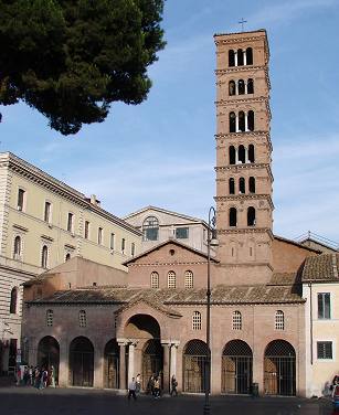 Santa Maria in Cosmedin and its fine belltower |
|---|
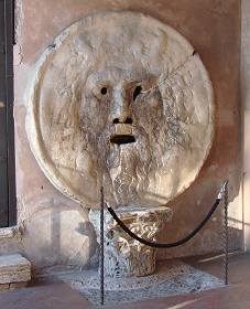 |
Very likely, in ancient times this used to be only the cover of a drain, as nearby ran Rome's main sewer, the Cloaca Maxima (see further); but in the past centuries, a legend sprung that if a lier placed his hand into the stone's mouth, he would have it clutched. And this 'test', made worldwide famous by a scene of the movie Roman Holidays (1953, right), is still an essential ritual for anybody who comes to Rome for the first time: crowds of tourists queue to have a picture taken, as they insert their hand into one of the city's most popular symbols. |
 (↑ above) A.Hepburn and G.Peck in Roman Holidays; (← left) the famous Mouth of Truth |
|---|
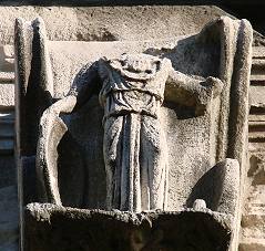
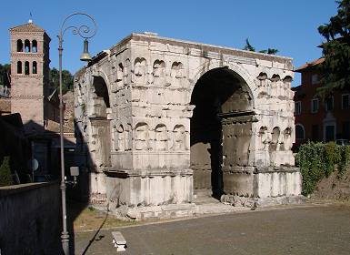 (↑ above) the arch of Janus and one of its surviving figures (right →) |
Some literary sources suggest that the arch was built by emperor Constantine I after his victory over Massentius (312).
|
|---|
During the 1200s, this arch was incorporated by the Frangipane family in their fortified estate, which stretched over the Palatine Hill (the small Frangipane Tower at the southern end of the Circus Maximus area, the Arch of Titus and the same Colosseum were included in this vast fortification). For this purpose, the archways of the monument were walled up. In 1837 any non-original superstructure was removed, in order to retrieve its original shape; but during these works, also what was left of the attic, wrongly believed to be one of the medieval additions, went lost. We still know what the arch looked like at an earlier stage thanks to a number of old etchings and paintings. |
 the arch in an etching by G.B.Piranesi (mid 1700s), referring to the monument as 'Temple of Janus'; note the upper part, now lost |
|---|
Behind the Arch of Janus stands the much smaller Arch of the Money-changers, named after the guild of bankers who, together with the cattle-dealers, had it built in honour of emperor Septimius Severus in AD 204, on the spot where a street called vicus Iugarius reached the Forum Boarium, i.e. the open area where the cattle market was held.
|
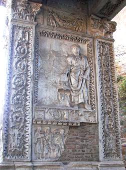 (left pillar) Caracalla and the empty space from which his wife was erased; also note the damage, filled with bricks |
It is a rather simple structure, consisting of two pillars topped by an archtrave, although every part of the monument is richly ornate with reliefs carved in white marble, which the whole arch is lined with (except the base). The dedication was not only to the emperor, but to his wife Iulia Domna, to his two sons Caracalla and Geta (who also became emperors) and to Caracalla's wife Fulvia Plautilla. However, since Caracalla, after the death of his father, had both Geta and Fulvia Plautilla assassinated (AD 212), he ordered their portraits and names to be taken off from any monument (damnatio memoriae); for this reason some figures among the ones carved on the arch, referring to the two personages who fell in disgrace, are missing. During the Middle Ages, a legend spread according to which in ancient times the bankers had hidden some gold by this arch; one of the pillars actually bears traces of a damage likely caused by treasure-hunters. |
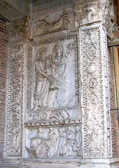 (right pillar) Septimius Severus and Iulia Domna; the third figure, their second son Geta, was chiselled off after 212 |
|---|
 the church of San Giorgio al Velabro |
Next to the monument is the beautiful church of San Giorgio al Velabro, which partly incorporates the right pillar of the aforesaid arch in its own porch. It was founded around the 6th or 7th century, and altered several times during its long history. Its present shape, that dates back mostly to the 12th century, was retrieved after a restoration work carried out in the 1920s that removed several later additions, including a Baroque façade of the 1600s. It is one of the earliest churches dedicated to St.George in the Western world, as the cult of this saint originally sparked in the East, in the Greek-Orthodox culture, and spreading to the West only after the first Crusades, in the 1100s. It was pope Zachary (741-52), a Greek, who moved into this church, originally dedicated to St.Sebastian, some relics of St.George (namely, his head, his sword and a fragment of the standard he carried), thus changing its previous title. San Giorgio al Velabro owes its name also to the site of the ancient Velabrum: this once was a muddy area, whose name likely sprung from an Etruscan word for "swamp". The origins of the city of Rome are to be sought for on this very spot; in fact, it was in the Velabrum that the two mythical twins Romulus and Remus, after having been set adrift in the river Tiber, were suckled by a she-wolf and were then found by shepherd Faustulus, who raised them. The legend goes that Romulus, as a young adult, founded Rome and became its first king. |
|---|
But way back in time, the Velabrum was also visited by Aeneas, the Greek hero mentioned in Homer's Iliad (9th or 8th century BC) and the main character of Virgil's Aeneid (late 1st century BC): he is traditionally considered the ancestor of the Roman people. According to these classics of ancient literature, Aeneas was the son of Anchises (a cousin of the Trojan king Priam) and goddess Aphrodite (i.e. Venus, in Roman mythology); having survived the fall of the city of Troy, together with a small crew of companions he fled to Italy, landing in Latium region, where he was welcomed by king Latinum. Aeneas fell in love with the king's daughter, Lavinia, who though was already bethrothed to Turnus, king of the Rutuli. This triggered a war that involved the several peoples who inhabited the region, such as the Etruscans and the Volsci. Aeneas allied with Evander (born to god Mercury and goddess Carmenta), king of Pallantium, a city located on the Palatine Hill, although he and his people, the Arcadians, were of Greek origin, as well. In the end, Aeneas won the clash against Turnus, married Lavinia, and founded the ancient city of Lavinium (50 Km / 31 mi. south of Rome), named after her. One of Aeneas' descendants was Rhea Silvia, a Vestal virgin, who was raped by god Mars, thus giving birth to the two aforesaid twins Romulus and Remus, yet having to abandon them due to her priesthood. |
 Eneas flees from Troy with Anchises and his son Ascanius (detail, Federico Barocci, 1598) |
|---|
 the scanty remains of the two twin temples; Sant'Omobono's church is in the background |
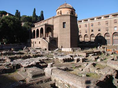
In 1937, archaeologic excavations carried out by the church, discovered the remains of an important complex, consisting of two twin temples entitled to goddesses Fortuna and Mater Matuta, dating back to the 6th century BC (i.e. the age of the last two kings of Rome, Servius Tullius and Tarquinius Superbus), but also earlier traces, among which fragments of Greek ceramics of the 8th century BC and even traces of pre-Roman inhabitants roughly datable to the 12th-16th centuries BC. Therefore, these findings seem to confirm that myth and historical truth partly overlap in locating in this area the roots of the Roman civilization. It is not by chance that opposite the twin temples, stood Porta Carmentalis, a city gate belonging to the oldest set of walls (see Servian Walls), named after goddess Carmenta, the mother of king Evander. And another stunning coincidence is that the original name of the same monarch, Εύανδρος (Euandros), which in Greek translates as "good man", has the same meaning of the Italian name Omobono, after which the nearby church was entitled. |
|---|
Along the stretch of river that flows near Santa Maria in Cosmedin's church, in Roman times ended Rome's main sewer, the Cloaca Maxima, one of the earliest large public works (late 6th century BC), which collected the water drained by the Roman Forum, and running below the Velabrum and Cattle Market areas, poured into the Tiber. Today, below Palatino Bridge, the spot where the sewer ended is still visible, at the bottom of a large round opening in the wall by the river's eastern bank, partly covered by the local vegetation. Instead, behind the church of Santa Maria in Cosmedin stretches one of the most dramatic sites of Ripa district: the area of the famous Circus Maximus [7], Rome's most ancient and largest hippodrome. |
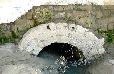 the outlet of the Cloaca Maxima |
|---|
A steady structure mostly made of concrete was built in the 2nd century BC, and the seats were added under Julius Caesar (c.46 BC). By that time the circus had already developed its final shape, although several following rulers throughout the imperial age enlarged it, improved it and restored it. The last races held in the Circus Maximus were held by king Totila in 549, in times when Rome had already fallen to the Ostrogoths: therefore, the hippodrome was actively used for about one thousand years! Since the 1st century BC, its spine (i.e. the narrow platform in the centre of the track) was decorated with the tall Egyptian obelisk that now stands in piazza del Popolo, and from the 4th century also by the even taller spire now found by the basilica of St.John in the Lateran (see Rione I Monti, Rione IV Campo Marzio, and Obelisks, page 1). |
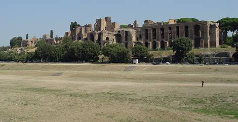 the area where the Circus Maximus stood, and the Palatine Hill in the background |
|---|
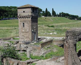 Frangipane Tower, also known as the Small Mill Tower |
At the southern end of the area stands the small Frangipane Tower (also known as Torre della Moletta, i.e. "Small Mill Tower"), which belonged to the vast fortification of the Frangipane family, previously mentioned. The circus lay were in very early times was the swampy Murcia Valley, located in the valley between the Palatine Hill (which belongs to Rione X Campitelli) and the Aventine Hill, originally crossed by a brook; when the hippodrome was built, the water kept flowing below it, so that when the circus slowly disappeared, it emerged once again, turning the arena into a huge pool of mud. In fact, the aforesaid Frangipane Tower, located along the course of the stream, was turned into a small mill to exploit the water flow, giving reason for its second name. |
|---|
Here also stands Santa Sabina's church [10], one of Rome's finest and best preserved early basilicas, brought back to its original look thanks to an extensive restoration work. Its main door is an original 5th century masterwork, covered with small cypress wood panels, carved with biblical scenes, rich in details.
At the bottom of a small public park adjoining the church, called the Orange Tree Garden, the view stretches from the hill's top over most parts of Rome. |
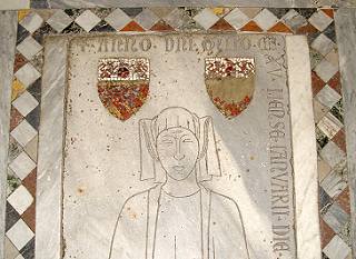
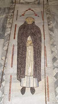 the tomb of Muńoz de Zamora |
|---|
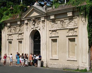 the Priorate of Malta: a queue for peeping through the famous keyhole... |
On its western side is large villa belonging to the Priorate of Malta [11]. Its door has a keyhole through which romans and tourists alike traditionally peep: from this unusual viewpoint St.Peter's dome can be seen, far away in the distance, at the bottom of a charming gallery of trees.
|
|---|
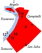
|
 Ripa's Fountain of the Rudder |
|---|